The Lake Lucerne region has so many beautiful hiking areas, it’s hard to choose. So I’ve selected the best hikes in the region, with both popular destinations like Engelberg and quieter locals only places.
I’ve grouped the hikes by easy, moderate and challenging, but depending on your fitness and hiking experience, you might find a hike easier or harder than I describe. Stay safe and have fun out there!
Quick Decision
| What you want | Suggested hike |
|---|---|
| Famous | Stoos Ridge Trail Staüben Falls |
| Best views for least work | Pilatus Tomilshorn Rigi panorama Golzernsee |
| Fun activities | Pilatus Tomlishorn (toboggan, ropes park) Walenpfad (toboggan, playground, barefoot path) Stoos (playground, marble run) |
| Free | Lai da Tuma Lungernsee Gotthard 7 Lakes Balmer Ridge Göscheneralpsee Staüben Falls |
| Locals only | Brisen peak Hoch Gumme |
| Spring (from late May) | Staüben Falls Fürenalp |
| No crowds | Seewlisee Gotthard 7 Lakes Balmer Ridge |

How to save money on these hikes
Many travelers purchase the Swiss Travel Pass, which includes all public transport like trains, buses, trams, and boats. This pass also gives you a discount (usually 50%) on many mountains, including most listed below.
➡️ Buy Swiss Travel Pass here.
Another option is the Lucerne Travel Pass, which includes free public transportation and mountains transport in the Central Switzerland region.
Panorama hikes with continuous views
If you want to maximize the views, these mountain trails have spectacular panoramas for practically the whole hike.
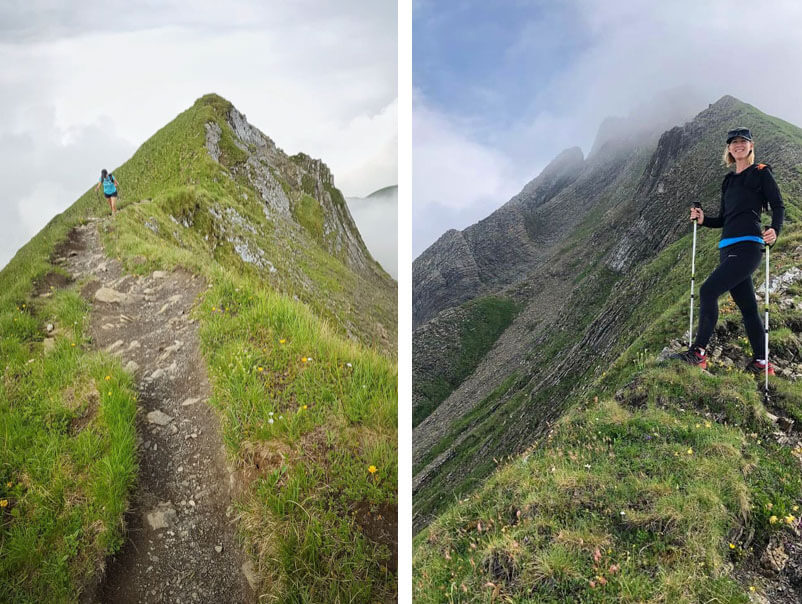
1. Stoos Ridge Trail
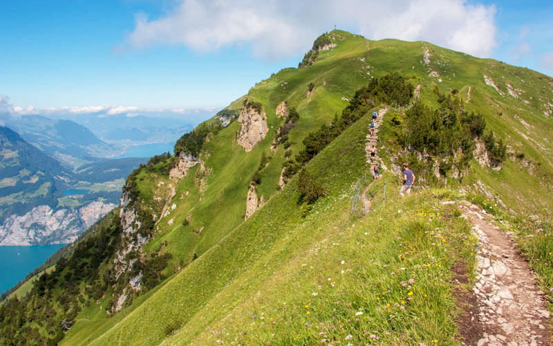
The Stoos ridge trail is one of the most popular trails near Lucerne for good reason, with spectacular views over Lake Lucerne.
The trail is well built but there are many exposed sections with steep slopes to the side, no safety railings. So best for those with hiking experience wearing sturdy hiking shoes.
- Trail: Moderate • 2 h • 4.4 k • 300m up/down
- Starting point: Stoos funicular train
- From Lucerne: 45 mins by car, 1hr10 by train/bus
➡️ See details for Stoos Ridgeline Trail
2. Rigi Panorama Trail

Mt Rigi is one of the closest mountains to Lucerne and a popular destination for many travellers. We suggest the Panorama trail, which is easy walking on a wide, mostly obstacle-free path. The trail includes a beautiful cliff walk section, which is safely secured with fences.
You can easily shorten this to 4 km or even just 1 km, by catching the mountain train earlier. There are restaurants along the way and a playground at the end. This trail is also possible in winter.
- Trail: Easy • 3 h • 8.2 km one way • 230 m up, 320 m down
- Starting point: Rigi train in Arth-Goldau
- From Lucerne: 35 mins by car, 45 mins by train, 1hr10 by boat
➡️ See details for Rigi Panorama Trail
Suggested tour: Classic round trip from Lucerne (with boat cruise)
3. Mt Pilatus Tomlishorn

Mt Pilatus is easy to reach by cable car or cogwheel mountain train. From there, you can do a short hike to the Tomlishorn peak for an even higher (and better!) view.
Most of the path is cut into the side of the mountain, but safely secured with railings on one side. For experienced hikers, this is an easy hike. But beginners and non-hikers may find this a little challenging with uneven terrain and stairs up to the viewpoint.
- Trail: Moderate • 1h • 3 km there and back • 150 m up/down
- Starting point: Pilatus Kriens cable car – Schlossweg 1, 6010 Kriens
- From Lucerne: 10 mins by car, 15 mins by train
➡️ See details for Tomlishorn hike
Suggested tour: Pilatus Golden Round Trip from Lucerne (with boat cruise)
4. Walenpfad panorama trail

So much drama on this hike! After enjoying a beautiful alpine lake, head up the mountain to a remote dairy hut to sample local cheese.
Then traverse the mountain, up down up, through cow meadows, rocky passages and panorama views for day. If you are hiking with children, they’ll be rewarded at the end with a bunch of fun amusements including a sensory barefoot path, summer toboggan and playground.
- Trail: Moderate • 4 h • 10 km one way • 590 m up, 410 m down
- Starting point: Fell cable car – Dorfstrasse 6387 Wolfenschiessen
- From Lucerne: 30 mins by car, 40 mins train/bus
➡️ See details for Walenpfad hike
5. Schächental High Mountain Trail

This trail traverse a mountain full of dramatic peaks, grassy fields, and dense forests. It hikes up to the little Fleshsee lake and mountain cafe, nice place for lunch.
Then climb up to the Hüenderegg peak viewpoint before descending through the forest to the cable car. It’s a one-way trail that takes a little schedule planning to avoid wasting time at the bus stop.
- Trail: Moderate • 3h30 • 9k • 260m ⬆️ 430m ⬇️
- Starting point: Brügg-Biel cable car
- From Lucerne: 30 mins by car, 1h15 by public transport
➡️ See details for Schächental High Mountain Trail
Easy lake walks with mountain views
These lakes are easy to reach with short walks and sometimes mountain transport. All have easy walking paths around the lakes.
6. Glattalpsee

Ride a little cable car up the mountain. Then an easy, flat walk to and around this beautiful alpine lake. There’s a mountain hotel and restaurant near the cable car. But we prefer a picnic on the lakeshore.
- Trail: Easy • 2 h • 7 km loop • 60 m up, 50 m down
- Starting point: Sahli-Glattalp cable car – Sahliboden, 6436 Muotathal
- From Lucerne: 1h10 mins by car, 2h by train/bus
➡️ See details for Glattalpsee hike
7. Lungernsee

Easy stroll around a beautiful bright blue lake with mountain views. There are lots of picnic areas with fire pits along the way and restaurants on both ends of the lake.
We suggest the short detour to two waterfalls. If you need a shorter hike, you can just walk half the lake and take the train back to your starting point.
- Trail: Easy • 2h30 • 9.5 km loop • 140 m up/down
- Starting point: Kaiserstuhl OW train station
- From Lucerne: 35 mins by car, 50 mins by train
➡️ See details for Lungerersee lake walk
8. Golzernsee

From the cable car, it’s an easy walk on a wide dirt path to reach this alpine lake, popular for swimming, picnics and fishing. There are a mountain restaurants nearby for lunch.
If you want a longer hike, you can walk up to a viewpoint up the Maderental valley and also hike down the river. For very long day, you can follow the Höhenweg Maderental trail up to Wildgällerhütte mountain hut.
- Trail: Easy • 2 h • 7 km loop • 60 m up, 50 m down
- From Lucerne: 1h10 mins by car, 2h by train/bus
➡️ See details for Golzernsee hike
9. Arnisee

Ride a tiny cable car up the mountain, then a short hike to the lovely Arnisee alpine lake, where you’ll find nice picnic areas and places to lounge.
You can do an easy walk around the lake, about 20 mins. There are several more difficult hiking trails in the mountains above the lake.
- Trail: Easy • 1 h • 2.7 k loop • 60 m up, 50 m down
- Starting point: Intschi-Arnisee cable car – Gotthardstrasse 22, 6476 Intschi
- From Lucerne: 45 mins by car, 1h26 by train
➡️ See details for Arnisee
Waterfall hikes
These mountain trails lead to big waterfalls.
10. Fürenalp
From minute one, it feels like the biggest mountains you ever did see. After riding up a tiny cable car, you follow a relatively easy mountain path through alpine meadows to a huge waterfall.
Then down along the rushing river back to your starting point. Locals only on this one, so you feel like you discovered a secret.
- Trail: Moderate • 3h30 • 9 k • 10 m up, 750 m down
- Starting point: Fürenalp cable car in Engelberg
- From Lucerne: 40 mins by car, 1hr20 by train/bus
➡️ See details for Fürenalp hike
11. Stäuben Falls

These powerful waterfalls are at the far end of the Unterschächen valley. You can reach them with an easy walk on a service road along the river, about 1 hour. Then back the same way.
But we prefer starting with a small cable car up and a beautiful hike through alpine meadows high above the falls. Then descend into the valley to enjoy the main event. Then an easy walk along the river back to your starting point.
- Trail: Moderate • 2h30 • 8.3 k • 150 m up, 650 m down
- Starting point: Ribi-Wannelen cable car near Unterschächen
- From Lucerne: 50 mins by car, 2hr by public transport
➡️ See details for Nideralp Mountain Trail to Stäuben Falls
Mountain hikes to alpine lakes
These alpine lakes are high up in the mountains, only accessible by foot.
12. Spilauersee

This hike so much variety, a beautiful alpine lake, big mountains, and dramatic views over cliffs. The first bit of fun is the tiny open-air cable car which carries you up the mountain.
Then up, up, up the mountain to panorama views across the Lake Lucerne region. Then down, down, down to the beautiful blue lake, where brave souls might jump in the chilly water with the fish. Make sure to stop at one of the mountain dairy for lunch or at least to sample the local cheese.
- Trail: Moderate • 3h15 • 7.2 k • 480 m up/down
- Starting point: Chäppeliberg-Spilau cable car, Riemenstalden Chäppeliberg
- From Lucerne: 1 h by car, limited connections by bus
➡️ See details for Spilauersee
13. Lai da Tuma – source of Rhine river

This small lake is the source of the Rhine river. The trail starts at the Oberalp mountain pass and hikes up a rocky path to this magical spring surrounded by mountains. There is a mountain hut just above the lake that serves drinks and simple snacks.
- Trail: Moderate • 4 h • 8 k round trip • 460 m up/down
- Starting point: Oberalppass
- From Lucerne: 1hr15 by car, 2hr40 by train/bus
➡️ See details for Tomasee hike
If you prefer a longer, more difficult hike, you can do the loop that hikes first to Pazolastock at 2739m, then down to the lake. The views are incredible above the lake and well worth the extra effort. See longer trail info.
14. Göscheneralpsee

This reservoir high up in the mountains gets its bright blue color from the glaciers melting above it. You can drive or take a bus directly to the dam.
The hike circles the lake, crossing rivers, alpine meadows, and boulder fields. You’ll usually meet goats along the way, If you’re brave, you can take a short dip in the chilly water. There are two mountain huts high above the trail, if you fancy an overnight in the area.
- Trail: Moderate • 4 h • 8 k round trip • 460 m up/down
- Starting point: Göscheneralp, Dammagletscher bus stop
- From Lucerne: 1hr15 by car, 2hr30 by train/bus
➡️ See details for Göscheneralpsee Lake Hike
15. Gotthard 7 lake hike

Visit seven alpine lakes in a beautiful rocky landscape on this hike near the Gotthard pass. Starting at a dam and large reservoir, hike up the mountain to discover a series of small alpine lakes.
A small detour leads to mountain pass where you see even more mountains and even glaciers on the other side.
This hike requires a good level of fitness to manage the switchbacks and uneven terrain, but it’s not dangerous. No restaurants along the way, so bring a picnic to enjoy next to one of the lakes.
- Trail: Moderate • 4h • 11.2 km loop • 630 m up/down
- Starting point: Lake Lucendro dam near Gotthard Pass
- From Lucerne: 1h15 by car, 2hr20 by train/bus
➡️ See details for Gotthard 7 Lake hike
16. Seewlisee alpine lake
It’s a long tough climb to reach this lake, but well worth the effort. You start with a thrilling ride on a tiny open-air cable car. Then many switchbacks up the mountain, mostly in the forest, where you’ll be happy to have your hiking sticks.
Eventually you break out to big beautiful mountain views and the lake. There is a mountain hut and café next to the lake, where you can get refreshments and stay the night.
- Trail: Moderate • 4 h • 10 km one way • 1040 m up/down
- Starting point: Chilcherberg cable car – Brandistrasse, 6473 Silenen
- From Lucerne: 40 mins by car, 1h30 mins train/bus
➡️ See details for Seewlisee hike
Summit hikes
These hikes have steep mountain trail up to viewpoint on peaks and passes.
17. Grosser Mythen peak hike
This impressive peak is an icon of central Switzerland, so it’s very satisfying to reach the top and do a little victory dance. It’s a demanding mountain trail, with steep rocky switchbacks gaining about 400 m of elevation over 2km.
⚠️There are very steep slopes on the side of the trail, not always with railings. There have been some deaths on this trail, so best for those with hiking experience who are not afraid of heights.
- Trail: Difficult • 3 h • 6.5 k • 660 m up/down
- Starting point: Brunni-Holzegg cable car – Brunnistrasse 14, 8849 Alpthal
- From Lucerne: 45 mins by car, 1h20 by train/bus
➡️ See details for Grosser Mythen Peak Hike
18. Niederbauen Kulm peak hike

Ride a cable car up the mountain to reach this trail. It’s a steep climb up to the top of the Niederbauen peak, where you can peer over the cliffs to the lake.
Then a steep hike down on switchbacks along a beautiful ridge with mountain views. Less experienced hikers can stay on the lower trail and still reach a beautiful viewpoint over the lake.
- Trail: Moderate • 2h30 • 5.3 k • 300 m up/down
- Starting point: Niederbauen Cable Car – Seelisbergstrasse 2 6376 Emmetten
- From Lucerne: 25 mins by car, 1 h by train/bus
➡️ See details for Niederbauen Kulm Hike
19. Balmer Ridge

Starting near the Klausen pass, this mountain trail leads up to the Balmer ridge, where you can admire so many dramatic peaks and a unique rocky landscape on the other side of the pass.
Then traverse the ridge to the Ruosalper Chulm pass and loop down and back through alpine meadows. This one is definitely locals only. Bus service is very infrequent here, so plan carefully.
- Trail: Moderate • 2h30 • 6.3km • 555m up/down
- Starting point: Hotel Klausenpass
- From Lucerne: 1h10 by car, 2h30 by public transport
➡️ See details for Balmer Ridge Trail
20. Haldigrat to Brisen peak
If you need a little thrill and bit of a workout, this hike will scratch that itch. My pictures don’t do it justice, but climbing along this ridge was absolutely delightful for an experienced hiker comfortable with some risk.
A cable car and chair lift bring up you up to the good stuff. Then hike up the ridge to the Brisen peak, where you’ll feel on top of the world. The downhill is a bit of a slog, but the views are nice along the way.
- Trail: Difficult • 4 h • 9 k loop • 380 m up, 1140 down
- Starting point: Dallenwil-Niederrickenbach gondola
- From Lucerne: 20 mins by car, 40 mins by train
➡️ See details for Haldigrat Brisen hike
21. Türren to Hoch Gumme

After riding a cable car, it’s a steep climb up through alpine meadows to a ridge. Then up the ridge to the Hoch Gumme peak, with views over jagged cliffs dropping steeply towards the turquoise waters of Lake Brienz.
This is a loop variation of the Brienzer Rothorn ridge trail, with easier logistics since you start and end in the same location.
- Trail: Difficult • 4h30 • 11.5km loop • 860m up & down
- Starting point: Lungern-Türren cable car – Wichelstrasse 2, 6078 Lungern
- From Lucerne: 40 mins by car • 44min by train + 20 min walk
➡️ See details for the Hoch Gumme Peak Hike.


2 responses
Are the costs listed (example below) for trail access fees?
Trail: Moderate • 2 h • 4.4 k • 300m up/down
From Lucerne: 45 mins by car, 1hr10 by train/bus
Cost: CHF 50/adult, discounts with GA, SBB Half-fare, Swiss Travel Pass
The costs are typically for the mountain transport like cable cars and mountain trains. In general, there is no costs to access trails in Switzerland.