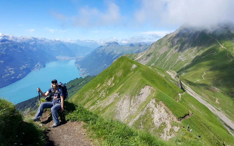
This circular mountain trail climbs through alpine meadows to a high ridge, where jagged cliffs drop steeply towards the turquoise waters of Lake Brienz. It’s one of our favorite views in Switzerland that we look forward to visiting again and again.
It’s a demanding route, but the spectacular panorama makes the effort worthwhile. Be aware that a few sections are narrow and exposed, so best suited to experienced hikers comfortable with heights.
After the hard work, you’ll love lunch at the Schönbüel mountain guesthouse, which serves tasty versions of Swiss classics.
If you were considering the Brienzer Rothorn Ridge Trail, this alternative offers many of the same highlights with less hassle. You don’t have to pre-book and the loop starts and ends in the same place, so no complicated logistics.
Keep reading for all the details you need to plan this outing.
Quick info
| Region | Lake Lucerne Region • Obwalden |
| Starting point: | Lungern-Türren cable car – Wichelstrasse 2, 6078 Lungern |
| By car: | Metered parking at cable car station From Lucerne 40 mins, Zürich 1hr20, Interlaken 35 mins |
| By public transport: | Train station: Lungern. Then 20 min walk to cable car station. From Lucerne 45 min, Zürich 2hr, Interlaken 1h20 |
| Trail: | 4h30 • trail map |
| Distance: | 11.5 km loop |
| Difficulty: | difficult • 860m up & down |
| Path Type: | T2/T3 • narrow mountain trail with uneven terrain and some steep exposed section with chain handrail |
| Highest point: | highest point 2200m |
| Open: | usually July thru mid Oct • check trail status |
| Cost 2025: | Cable car return ticket – CHF 36 Adult |
| Discounts: | Discount 50% with Swiss Travel Pass, Swiss Half Fare Card or GA Free with Luzern Tell Pass |
| Services: | restaurants at beginning and middle of trail |
| More info: | turren.ch • webcam • weather • instagram |
Gallery


Trail overview
This map shows the important aspects of the hike.

Step-by-step instructions
- By public transport, you arrive at the Lungern train station. Then walk or arrange the free shuttle to the Turren cable car.
- By car, you park directly at the Turren cable car.
- Ride the cable car to Turren, where you’ll find a restaurant and toilets.
- Hike the loop clockwise, up to the Männli peak.
- Continue on the ridge to Hoch Gumme (or skip the peak and go directly to the Schönbüel restaurant).
- Hike down the peak and traverse to the Schönbüel restaurant for lunch.
- Hike back down to Turren cable car and ride down the mountain.
Trail map
The map below shows the loop trail, starting and ending at the top of the Lungern-Turren cable car. We prefer doing the trail counter-clockwise, but it can be done in either direction.
See trail map on Komoot • SwizerlandMobility
⚠️Note: After the Hoch Gumme peak, the trail is quite exposed, with steep slopes to one or both sides. Some sections have a cable hand rail, but not all. If this makes you uncomfortable, you can skip this by taking the main trail directly to Schönbüel instead of going to Hoch Gumme.
How to get there
This trail is is located near the Lungern village, about halfway between Lucerne and Interlaken. You reach the trail with the Lungern-Turren cable car.

By public transport
Take a train to Lungern. Walk about 20 mins through the village to the Lungern-Turren cable car.
Or you can book the free shuttle provided by the Turren cable car. The day before, call (041 679 01 11) to arrange the shuttle, informing them of your arrival time. Although there is no fee, they appreciate a voluntary contribution to help cover the cost of this service.
By car
The cable car is located at Wichelstrasse 2, 6078 Lungern. There is metered parking next to the cable car station.
Planning your day
Tickets
You’ll need a return ticket on the Turren-Lungern cable car. You can purchase tickets online or at the ticket office onsite.
In 2025, a return ticket costs CHF 36. See current prices.
Discount for children, Swiss Travel Pass, Half Fare Card, and GA. Free with Lucerne Tell Pass.
Don’t skip the cable car: Although there are trails up the mountain from Lungern to Turren, in winter, these trails are not maintained and not recommended. Also you would have to hike up about 1800m of elevation, also not recommended.
Opening Times
The cable car starts summer season in late May. But this trail is usually open for summer hiking from late June to mid October.
During summer season, the cable car runs daily from 8:20 – 17:00, until 18:00 on Sat, Sun and holidays. It leaves every 20 mins and the journey is 7 mins.
What to wear & bring
We suggest wearing sturdy hiking shoes or boots with grippy tread and bringing hiking sticks.
Dress appropriate to the weather forecast. Although it can be very warm in summer, the trail is high elevation and the ridge prone to wind, so the temperature can be colder than you can expect. We suggest bringing layers so you can adjust as needed.
You can buy drinks and food at the Schönbüel mountain restaurant along the trail. But otherwise no services. Best to bring a minimum 1L of water and snacks.
Where to eat
Near the cable car you’ll find the self-service Turren restaurant. After about 3h hiking, you’ll reach the Bärghuis Schönbüel (see on map), which has a restaurant.
Photo story of trail
1. Ride cable car up to Turren
Here is the entrance to the cable car station. You can purchase tickets at the office is inside. There is a WC downstairs.

The cable car fits 40 people. Travel time 6-7 mins.

View from the top of the cable car down to Lungern.

2. Start of trail
The trail starts up a paved road that crisscrosses the mountain. This part is a bit boring, so nice to get it over with at the beginning.

Follow signs to Dundelegg and Schönbüel.

Looking back as you walk up the road.
As you near Dundelegg, you fork left, leaving the road and now on a footpath the rest of the way.

3. Hike up to Männli peak
Now follow signs to Rückenegg and Schönbüel.

The hike up to Rückenegg.

Looking back towards Lungern.

Keep following signs to Schönbüel.


Looking west towards the Jungfrau Region mountains.

Getting a bit steeper as we get higher.
Looking down with the Sarnensee lake in the distance.
Last push to the Männli peak. A bunch of hikers were taking a break here before starting the next climb.

Cross at the Männli peak 2056m.

4. Hike along ridge
Now the ridge gets exciting. You’ll need steady footing on this part.

Looking back on the ridge
The section is relatively flat, giving you a little break before the next climb.

5. Hike up and over Hoch Gumme peak
Now follow signs to Rothorn and Zwischenegg, which will lead you up to the Hoch Gumme peak. If you prefer to skip the peak, you can fork left and walk directly to the Schönbüel guesthouse.

Below you can see the easier trail to Schönbüel leading to the left, while we continue up the ridge.


Getting a glimpse of Lake Brienz and the Brienzer Rothorn peak on the right.

Looking down to the alp we’ll be hiking through in a couple hours.

Finally a view of Lake Brienz!

The most dramatic part of the hike.

The trail leading down from Hoch Gumme.


6. Loop around to Schönbüel
When you join the main trail, follow signs to Schönbüel for the restaurant.

The trail traverses through this rocky mountainside.

A few parts have a narrow path with a steep drop to the side. I was happy to have the handrail.
Crossing through some schale. It had some trail damage, making it a bit tricky to walk on.

Nice flat trail leading to the Schönbüel restaurant.

Great view from their terrace.

They serve really good versions of the Swiss classics, a step up from most other huts. I particularly liked the Älplermagronen.


7. Down to cable car
Now follow signs to Turren.

You’ll pass through Breitenfeld, just a cluster of dairy huts, no services here.

Follow trail signs to Turren.

Usually lots of cows in this area during summer.

The views are a little less dramatic on this part, but still beautiful.

Gets a little steep at the end. My knees were glad to be almost done.

Arriving back at the cable car. It comes every 20 mins, so you might have a bit of a wait.