This lovely alpine lake is a quiet gem, partly because only tough hikers with good fitness are likely to make trek up to see it, not casual day trippers or tourists. There is a mountain hut and café next to the lake, where you can get refreshments and stay the night.
To reach the trail, we took a slightly scary open-air gondola, definitely not for those scared of heights. It’s a tough climb, about 1000m elevation gain over 4km to reach the lake, but definitely worth the effort.
Contents
Shorter options: There are two other pretty alpine lakes near this one that are easy to reach with kids: Golzernsee and Arnisee. I heartily recommend both.
| Location: | Silenen, Central Switzerland |
| Address: | Chilcherberg cable car – Brandistrasse, 6473 Silenen |
| By car: | Limited free parking at cable car or in town From Lucerne 45 min, Zürich 1hr15 |
| By public transport: | bus stop Silenen, Dägerlohn + 10m walk to cable car station From Lucerne 1h17, Zürich 1hr30 |
| Trail: | 10 km, about 6 hrs |
| Elevation: | highest point 2000m, total ascent/descent 1040m |
| Condition: | dirt mountain path, steep climb, no strollers |
| Skill: | challenging |
| Open: | best late June through mid October |
| Cost 2025: | Cable car return CHF 14/adult Cash only! No discounts with travel cards. |
| More info: | www.chilcherbergen.ch – www.seewli.ch |
Location
This trail is located south of Lucerne. It is accessed with the Chilcherberg gondola in Silenen near the north side of the Gotthard tunnel.
Trail Overview
Here is the hiking map for the Maderanertal area. Download full version (PDF).

Hiking map
Here’s my more detailed hiking map. It’s about 4km to the lake and mountain hut, then an optional walk around the lake, about 2km. Then 4 km back down to the cable car. It took us about 6 hrs with lots of breaks to take photos.
See trail map on Komoot • SchweizMobil • AllTrails • OutdoorActive
Planning your day
Posted time to the lake is 2hr30. It took us (two motivated adults) about 2hr10 to get to the lake, about 1hr walking slow around the lake taking pics, 30 mins at the cafe, and 1h30 back down. I’d plan about 6 hours total.
Make sure to take as much water as you need. There is no drinking water on the trail. The mountain hut has a cafe with drinks and snacks. You can stay there overnight, but call in advance.
I recommend hiking sticks and sturdy hiking shoes. The trail is well built but many parts are steep and slippery.
Getting to Silenen
By public transport: Get yourself to the bus stop Silenen, Dägerlohn. The bus drops you off in the tiny village. Then you have to walk about 10 mins uphill on a one-lane road to the cable car station, as shown on the map below.
![]()
By car: From the A2 freeway, take the #38 exit Amsteg, then follow signs to the Silenen village. Then follow the tiny white sign to “Luftseilbahn”. Best to look at the map and follow your GPS. You’ll drive up a one-lane road, past a church to the tiny self-service cable car station.

There are about 10 parking spots here (make sure they aren’t marked Private), but even on a quiet weekday at 7:00, most were taken. So you might need to park in the village. I’ve shown some possible parking spots on the map above. I’m not positive you are allowed to park in those alternate spot, but they looked promising.

Riding up the gondola
This is the open-air gondola that fits four people. It feels scary but you should be safe if you stay in your seat and don’t open the door (no lock!).

The gondola operates between 7:00 and 19:00. There isn’t an operator at the valley station. So you have to call the gondola operator on the provided phone to ride up. Open the phone box shown below and push #5 for two seconds. Then listen for the operator and say “Ich möchte bitte hochfahren” which means “I would like to ride up”. He’ll say something back (I couldn’t understand his dialekt).
Then get in the cable car. The back seat has a door that swings upward, like a Lamborghini scissor door. For the front seat, you can lift the wall up and off, then replace it after the passengers are loaded. Then just wait until it starts moving and enjoy the ride! You pay for your ticket in cash at the top – CHF 12/adult for round trip, CHF 6/kids, no discounts travel cards accepted.

Trail up to lake
Hooray, you made it! Remember to use the WC here before starting on the trail. Follow signs to Seewli.

I’m sorry to say that the trail is not very well marked. There were 3-4 forks with no trail signs. Stay on the path that looks more well used than the others.
Lots of switchbacks, lots of forest sections at the beginning.

Here’s a fork in the path. Do not take Hexensteig, go to your right.

Big views down the valley toward the Gotthard tunnel.

Big views up the mountain. So pretty!!!

Lots more switchbacks, so many switchbacks.

The trail plateaus after about 3km. Take a well deserved break here on the benches. It’s only about 30 more mins to the lake from here.

Now the path is relatively flat over to the lake. You’ll pass this nice waterfall.

At this blue sign, you can simply hike straight pass the sign, up and over the mound to reach the lake. Or you can follow the sign to the left to reach the mountain hut. Then you can hike from the hut over the mound to the lake.

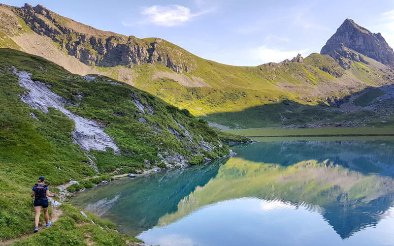
Around the lake
Even if you are tired, I highly recommend walking around the lake, a bit under 2km. Take your time and have a picnic. This is the reward for all your hard work.
Some cows greeted us on the far side of the lake. We didn’t linger as it seemed these four twins were babies of the mother nuzzling them on the left.

As you walk around the lake, you get different views of the same things. So nice!

Can we stay here forever?

Going back down
Before hiking down, we stopped at the mountain hut for some drinks. If you are too tired to hike down, they have overnight place for 20 people.

Happy to be above the clouds at 2000m today.

Hiking back down in sun and fog. The way back down felt much longer than the way up and so hard on the knees. The rocks and tree roots were slippery and I fell once, even with my hiking sticks for balance. Be careful!

My friend thought I shouldn’t bother writing this one up because no one will do it. Let’s prove her wrong! Please comment on the post if you hike this one. I want to know how many people do it.
See also
Here are alpine lakes in this area that easy to reach with kids.
Pin this for later…


13 responses
awesome hike!! they improved the signalling as well, so no need to worry about getting lost 🙂
I’m so glad you posted this one! I did it yesterday and it was so amazing!! Thank you you much! Definitely a gem! Did not have time unfortunately to walk around the lake but I’ll definitely come back one summer to enjoy the quietness and calmness of this beautiful place, maybe staying in the hut next time! I was told by a local that there is also a less steep way to reach this lake from Unterschächen (3H), starting with taking the cable car up to Sittlisalp. This trail also goes through the Seewligrat as I understood.
Thank you so much!
Glad you enjoyed it! Thanks for the tip about the hike from Sittlisalp. I wondered what was in that direction. I mapped it out and it looks like it’s still about a 700m elevation gain from that direction, but you would see something different, which would be fun.
I did this one yesterday and it was stunning! Thanks for all the tips.
I had some extra energy and hiked up to the ridge (directly across the lake from where you first arrive, if you have come directly from the trail, not the hut).
It’s worth it. There are two benches up there, drinking water that’s been piped up, and a beautiful view of the lake and distant mountains.
I so wanted to hike to that ridge! But we didn’t have time. I’ll just have to go again. Thanks for letting me know that it’s worth it.
thanks for writing. we plan to go hrre tomorrow 🙂
I hope you enjoyed it!
What a great hike! We did it today with my 12 yr old who also loved it. Amazing views, fun cable car and lovely and quiet. Thank you for all that you post – love your website!
Wow, good job you two! That’s a tough one. Glad you enjoyed the experience and that my website could be helpful. Hooray!
Absolutely! Thank you. I loved my hike last weekend—so quiet and gorgeous. Switchback City was worth the effort!
Hooray!
I‘m doing this today! I love that you’re posting some hikes now that aren’t just for kids—last week I did the Brisen ridge hike … solo! Your site is such a great reference for me.
Welcome! So glad you found something you like. Check all the hikes in the “challenging” section, which should be just what you’re looking for. https://swissfamilyfun.com/tag/challenging/ I’m doing lots of hikes without the kids these days, so keep checking back for more ideas.