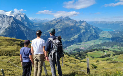
This nice trail is in the foothills near Interlaken, passing through idyllic farm fields with lovely views of Lake Thun and impressive mountains Niesen and Niederhorn.
It’s a good choice for spring in the Bernese Oberland, when the higher elevation trails are covered in snow. We did this trail during Easter weekend in the Jungfrau Region, snowboarding one day and hiking on this trail the next.
Contents
| Region: | Interlaken, Switzerland |
| Starting point: | Aeschi bei Spiez village |
| By car: | Metered parking: at Dorfstrasse 1, 3703 Aeschi bei Spiez From Interlaken 20 mins, Bern 35 mins, Zürich 1hr45 |
| By public transport: | Bus stop: Aeschi b. Spiez, Post From Interlaken or Bern 45 mins, Zürich 1hr45 |
| Trail: | 7.4 km loop |
| Time: | about 2 hours |
| Difficulty: | easy |
| Condition: | paved country roads and narrow dirt footpath, no strollers |
| Elevation: | highest elevation 1080m |
| Open: | usually April to November (also a winter trail) |
| Cost: | free |
| Extras: | picnic area, WC, and restaurant on trail |
| More info: | Aeschi website • webcam • forecast |
Gallery


Trail map
This is a loop trail, starting in the center of the Äeschi bei Speiz village. It starts on a paved country road, then onto a narrow dirt foot path that crosses farm fields.

View interactive trail map, download GPX, and print map on Komoot • SchweizMobil
How to get there
The trail is located just west of Interlaken in the foothills above Lake Thun. It starts next to the Aeschi bei Speiz bus stop and parking.

By car
Drive to Dorfstrasse 1, 3703 Aeschi bei Spiez and park the metered parking lot next to the Hallenbad (indoor swimming pool). The trail starts on the main road you drove in on.
By public transport
Take a train to Spiez, then bus to Aeschi b. Spiez, Post. The bus drops right at the trail. From Interlaken, it takes about 45-50 mins.
Planning your day
Cost
No cable car to reach this hike, so your only cost is bus fare or parking fees.
When to visit
This trail is open both in summer and winter as an official winter walking path. For summer hiking season, this trail is best from late April through early November.
Services
At the start of the trail, there is a kiosk near the parking that sells coffee and snacks. Also a Volg and Denner grocery where you can buy picnic supplies.
At about the halfway point, you pass through the tiny Aeschiried village. There is playground with picnic tables and toilet. There is also Restaurant Panorama that is open Thur-Sun.
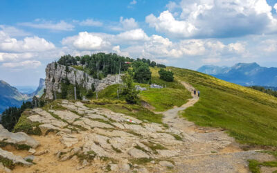
Photo story of trail
From parking and bus stop, follow the green sign for “Bänkli Rundweg.” We did the trail clockwise.

We started by walking along the main street.

We had these views of Mt Niesen behind us.

Just few minutes on this sidewalk along the main street.

The trail turns right onto a side street.

The trail is heading into these foothills, headed toward the Jungfrau Region mountains.

The first part of the trail is on a paved country road, almost no traffic.

The first bench of the trail.

View across to Mt Niederhorn, which has a fantastic viewpoint and ridge trail.
Enjoying these green meadows.
Branching off the road onto a footpath.

Follow those yellow “Wanderweg” signs. The pink signs are for the winter walking trail, which is almost the same.

Now on a grassy footpath heading uphill.
Perhaps my favorite bench of the trail.
From this bench, lovely views down to Lake Thun.

Continuing uphill with Mt Niesen in the background.

At the highest point, you get a nice view to the west, looking towards Kandersteg. Now head downhill through that small cluster of houses.
Walking by a few farm houses.
This farm has a fridge full of cheese and other farm products for sale. You can pay with Twint.

We got one of the mountain cheese to take home.

In this village, there is a small playground with a picnic table and toilets. We took a small break here.

The trail leaves the village and heads into the meadows again.

I love this style of bench with the branches for legs.

Now nice views of Mt Niesen the rest of the way.
Passing by several dairy huts waiting for the cattle return for summer grazing.
Descending quite of bit of elevation here.

Cute country cat.

One of the last benches on the trail.

Near the end of the trail, you reach the main road and turn right walking back up to the parking and bus stop.

All done! Hope you liked this trail.