This spectacular ridge hike has dramatic views over cliffs on one side and a sweeping panorama of the Jungfrau region mountains on the other. It follows the “Güggisgrat” ridge, starting at Niederhorn, then visiting the Burgfeldstand and Gemmenalphorn viewpoints along the ridge.
You can customize this trail from 4 to 11 km, doing a short version that’s easy for kids or a longer, exciting version on the more dramatic section of the part of the ridge. Keep reading for all the details for this trail.
Contents
| Region: | near Interlaken, Berner Oberland |
| Starting point: | Beatenbuch-Beatenberg funicular train – Beatenbucht, 3658 Sigriswil |
| By car: | Parking GPS: 46°41’08.3″N 7°44’49.8″E 15 mins from Interlaken, 1hr45 from Zurich |
| By public transport: | Beatenbucht bus stop 20 mins from Interlaken, 2hr from Zurich |
| Trail: | 4.4 km – longer option below |
| Time: | about 1.5 hours |
| Difficulty: | moderate |
| Condition: | narrow footpath |
| Elevation: | highest point 2053 |
| Open: | usually June to October |
| Cost: | cable car return CHF 59/adult Discount with Swiss travel cards |
| Extras: | restaurant, playground, picnic area, mountain scooters |
| More info: | website • webcam • forecast |
Gallery


Niederhorn overview
Here is the Niederhorn summer map showing the mountain transport and hiking trails. Of the many trails on this mountain, we like the ridge trail the best. I offer variations below to suit different needs.

1. Beatenbucht funicular train.
2. In Beatenberg, transfer to cable car.
3. Niederhorn viewpoint, with restaurant and playground. Short panorama loop near cable car station.
4. Ridge trail with variations;
- A: Niederhorn to Burgfeldstand viewpoint – 4 km there and back / 1h45.
- B: Niederhorn to Burgfeldstand, then hike down to Vorsaas – 7 km / 2h30
- C: Niederhorn to Burgfeldstand, continue to Gemmenalphorn (more difficult and exposed), loop back to Vorsaas – 11.2 km / 4h.
5. Vorsaas station – rent mountain scooters here, ride to Beatenberg.
6. Optional visit to St Beatus Caves
Hiking maps
For most casual hikers and families, we suggest the round trip hike from Niederhorn to the Burgfeldstand viewpoint, then back. If you need a shorter version, just walk as far as you like then turn back.

View interactive map, print map, download GPS on Komoot • SchweizMobil • OutdoorActive
Option B: Loop down to Vorsaas
Instead of returning to Niederhorn, you can hike down to the Vorsaas station. You get to see something different on the way back and your cable car ticket is a bit cheaper.
Loop to Vorsass: 2h30 • 7 km • 226m up, 622m down.
See trail on SchweizMobil • Komoot
Option C: Longer ridge trail to Gemmenalphorn
For experienced hikers and older children, we suggest the longer loop that continues on the ridge, visiting the Gemmenalphorn viewpoint. Then it loops back through the alpine meadows and forest to the Vorsass gondola station. This trail has exposed sections with steep slopes to one side. Best if you have sturdy hiking shoes and a good head for heights.
Trail to Gemmenalphorn: 4h • 11.6 km one way • 562m up, 949m down
See trail on Komoot • SchweizMobil • OutdoorActive
How to get there
Niederhorn is in the Bernese Oberland, a bit north of Interlaken (see on Google Maps).

To reach Niederhorn, you take a funicular train from Beatenbucht on Lake Thun up the mountain to Beatenberg. From there you’ll take a cable car to Niederhorn. If you have time, start in Thun, then take a ferry to Beatenbucht.
By car: Drive to Beatenbucht and park in the metered lot near the funicular station. Make sure to pay for the parking.
By public transport: From Interlaken, take a bus to Beatenbucht, about a 20 min ride. From Zurich, take a train to Thun, then a bus or ferry to Beatenbucht.
Planning your day
Tickets
In 2024, a return ticket from Beatenbucht to Niederhorn costs CHF 59/adult. If you are hiking, you can get a less expensive “Wanderbillet” aka hiking ticket. Just tell them where you plan to hike and they will sell you the right ticket.
Discounts for Swiss Travel Pass, GA and SBB Half-fare cards, and children 6-15. Free for Berner Oberland Pass, children under 6, and children with Junior Card.
Timetable
The Niederhorn mountain railways run for summer season from late April through early November. If you want to hike, the trails are usually open from June to October, snow dependant.
The mountain railways run from about 8:00 to 18:00, closting earlier in spring and fall, open later on some weekends. See current schedule.
Photo story
Riding up to Niederhorn
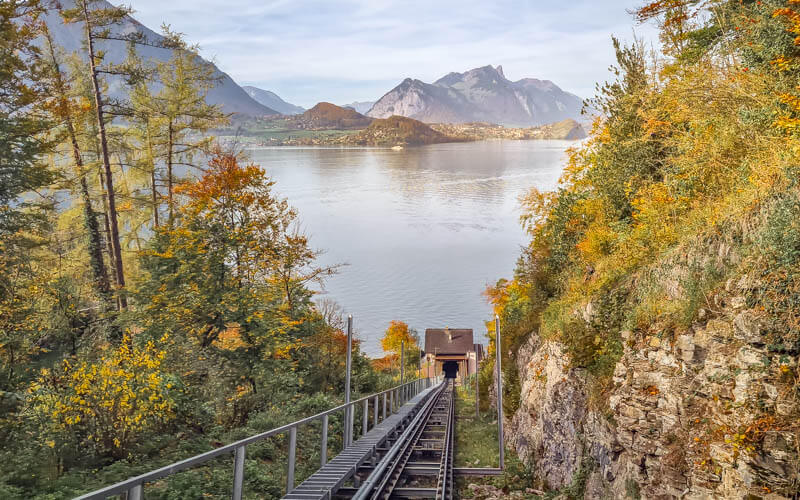
The pic below shows the valley station at Beatenbucht, with parking, the bus stop and a small lakeside cafe. Buy your tickets and board the funicular train, which takes you up to Beatenberg, a middle station.

The funicular has a glass ceiling, making it easy to catch the view.
In Beatenberg, switch over to the cable cars which take you to the top of Niederhorn.

Niederhorn viewpoint
The cable car drops you at the restaurant. there is a restaurant and small playground. Above the restaurant, there is a short walk to a higher viewpoint over the cliffs.

View eastwards.

This picture shows the fenced viewpoint at the top of Niederhorn.
View towards Lake Thun and Mt Niesen. One trail leads down the mountain here. But we prefer the ridge trail.
In front of the restaurant, there is a playground with an obstacle course.

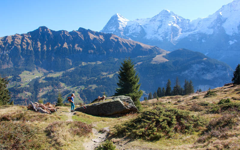
Ridge Trail
The trail to starts above the restaurant and heads along the ridge to the east.

You can get quite close to the edge. Be careful with small children or anyone that doesn’t have common sense or good balance.
The first part of the trail is quite easy, cutting through these meadows.

Now the trail will head uphill and get more rocky.

You are done with the ridge now, you can turn right here and follow signs Alp Oberburgfeld and Vorsass, the middle gondola station.

Looking back on the trail as we climb uphill.

On this section, there are some steep slopes to the side, but the trail is set back from the edge, so not too dangerous yet.

Slow burn up to the viewpoint.

Arriving at Burgfeldstand
Happy to arrive and Burgfeldstand and get this view.

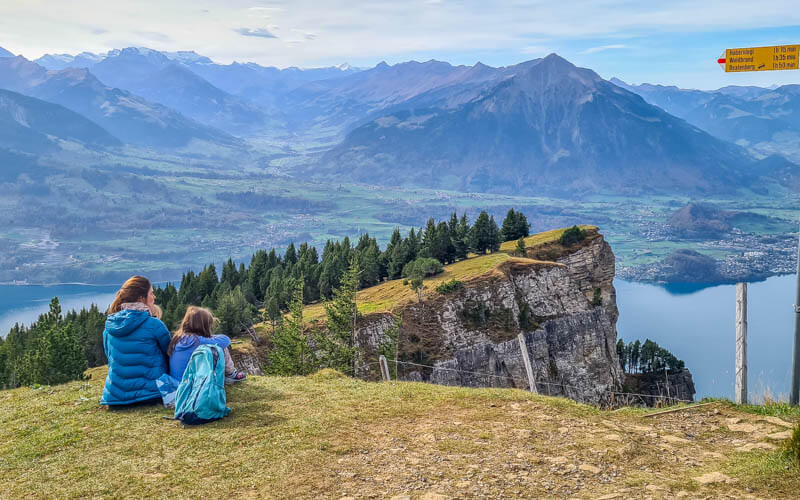
There are big meadows on the top of Burgfeldstand, so a nice place for a picnic. But the plateau slopes off the cliffs with no barrier. So don’t get too close to the edge.

We took a small break here and contemplated hiking further. But with the kids and my dad, we decided to loop back to Vorsass to ride the scooters.

On a foggy day, Burgfeldstand looked like this. All the people we saw on the trail stopped here then hiked back.

Continuing to Gemmenalphorn
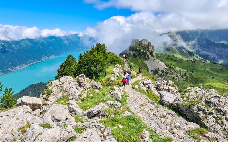
After Burgfeldstand, the trail gets more difficult and more exposed. Better for experienced hikers and older children.

Lots of stairs on this part, up and down.

The landscape continues to impress.
Lots of areas where the slope is very steep to one side of the trail with no barrier. Use caution.
The trail mostly stays high up on the ridge, but sometimes dips into the grassy slopes.

Looking back on the trail to Burgfeldstand.

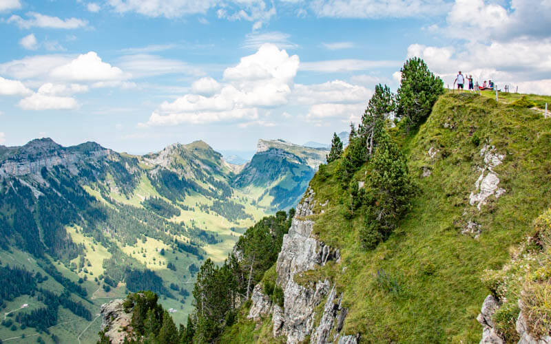
Arriving at Gemmenalphorn viewpoint
More crowded at Gemmenalphorn than we expected. We thought we’d stop here for a break, but decided to keep moving since it was so busy.

Lovely views from Gemmenalphorn.
Lots of people settle in here for a picnic. Some hike back to Niederhorn. Some continue on the ridge, like we did.

After Gemmenalphorn
Trail squiggles down for a bit.
The descends off the ridge into the alpine meadows.

Looking back at Gemmenalphorn where we were a few minutes ago.

At this trail sign, the trail forks in a few directions and can be a little confusing. Follow signs to Oberberg.

The trail continues across this slab of rock, looping back in the direction of Niederhorn.
Looping back to Vorsass
At Oberberg, you have a lot of choices. I suggest following signs to Oberburgfeld/Vorsass, where you can either ride the cable car or rent mountain scooters.

We have hiked the Panoramaweg 342 that continues downhill to the Waldegg village, where you can take the bus back to Beatenberg. But that last bit of the trail is in the forest and on a road, not super interesting. I think it’s much preferrable (and more convenient) to hike across to Vorsass.

At Oberburgfeld, continue following signs to Vorsass.

This part of the forest is delightful and you still have occasional views of the mountains.

We found lots of blueberry bushes in this area.

Here the trail joins the popular #1 trail from Niederhorn. The trail was pretty wide the rest of the way.


Lovely alpine meadows over here.
A picnic area with fire pits with plenty of wood.

The restaurant next to the Vorsass middle station. There is a little playground here and a small barefoot path.

You can rent a Trotti scooter to ride down to Beatenburg. The red scooters are small for younger children. My 9 year old took the bigger blue bike. There are helmets to use as well.

Other trail options
Hike: Niederhorn – Vorsass
The most popular hike in this area is the #1 trail from Niederhorn to Vorsass as shown below. Our hike joined the second half of this trail which was not obstacle free but possible with an all-terrain stroller. I saw the top half of the trail from above and it looked about the same. Pics below so you can judge for yourself.
This hike has three “Orientierung Lauf” (aka OL) options, where you use a compass to find specific landmarks. It looks like you can stamp a pass as you find the landmarks and get a prize at the end. We’ll have to try that next time. Details for this hike on the Niederhorn website.

Hike: Niederhorn – Gemmenalphorn – Vorsass
Here is the hike we planned to do, along the ridge to Gemmenalphorn, then back to Vorsass. I’ll report back on that hike hopefully next summer. Let me know if you do it.


3 responses
Hello,
Thanks for the nice post (and all the other great posts too)! I did the longer hike you mentioned. If I had a note, I would actually recommend going the opposite way-start at Vorsass and go up and around to Niederhorn. The ridge walk is much prettier than the walk down below, which has more difficult terrain in my opinion. There are a lot more craggy/exposed rocks to climb over on the lower path and when you are more tired at the end of the day it may be a bit of a let-down after the spectacular views from the top. If you start at Vorsass, then the nice mountain and valley views along with the ibex sightings are a great reward for the hike up, which you then get to enjoy the entire second half. I would also recommend poles for the bottom half and the top after you pass Burgfeldstand, especially if you have a baby on your back. The ridge path past Burgfeldstand does also have some drop-offs and I would be pretty hesitant to do with small children, unless they are much better behaved than I was as a kid.
Thanks for sharing your experience and perspective. Very helpful! I agree, sometimes hiking up is easier than down, even if you sweat more. And yes, hiking sticks would be very helpful on those steeper sections.
Hi, I admire that you set off for your hikes almost at every weather! Nice pictures.