The spectacular Saxer Lücke viewpoint in the Appenzell region has become famous thanks to social media. These spiky peaks are part of the Alpstein mountain range, with many impressive geological features.
The viewpoint is relatively easy to reach, starting with the Staubern cable car and 1 hour hike traversing the ridge.
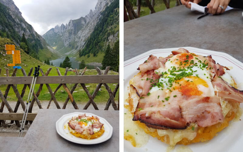
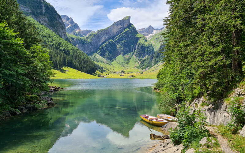
We also suggest a detour down to the beautiful Fälensee lake, where you can eat the best Rösti in Switzerland at a mountain restaurant.
The trail is a rocky path with uneven terrain, stairs, and some steep slopes to the side. So best for those that have sturdy hiking shoes and some experience with mountain trails. It’s popular with families, but if you go with children, take extra care on the steeper sections.
Saxer Lücke is one of our favorite places in Switzerland, where we love to taking our hiking friends and visitors. Keep reading for all the info you need to plan this hike.
Quick Info
| Region | Alpstein region, Eastern Switzerland |
| Start: | Frümsen-Staubern cable car – www.staubern.ch |
| By car: | Cable car parking: Frümsnerbergstrasse 9467 Sennwald From Zürich or Chur 1hr15 |
| By public transport: | Bus stop: Frümsen, Luftseilbahn Staubern From Zürich 2hr40, Chur 1h20 |
| Trail: | 2-3h • ⬇️ trail map |
| Distance: | 6-8 km there and back |
| Difficulty: | moderate • 300m up & down |
| Condition: | red/white mountain trail, rocky foot path, stairs, some exposed sections, no strollers! |
| Elevation: | highest point 1822m |
| Open: | usually late May to mid-October • trail status |
| Cost 2026: | cable car return – CHF 40/adult Free with Oskar card No discounts for Swiss travel cards or passes |
| Services: | restaurants at trail start and at lake |
| Where to stay: | Bad Ragaz – Boutique Hotel OchSen |
| More info: | appenzell.ch • nearby webcam: Hoher Kasten • forecast |
Gallery
Trail overview
This map shows an overview of the Saxer Lücke trail.

- Start by riding the cable car from Frümsen (1) to Staubern (2), where you’ll find a hotel/restaurant.
- Hike to Saxer Lücke viewpoint (3), about 1 hour traversing the mountain.
- Optionally hike down to the Fälensee lake and Bollenwees restaurant (4), about 25 mins down.
- Then back the way you came.
For a longer longer hike, you can start at Hoher Kasten (5) instead of Staubern.
Hiking map
Below is the detailed trail map for the Saxer Lücke hike.

See map on Komoot • SchweizMobil • OutdoorActive
Difficulty
This trail is a white/red mountain trail, well built and maintained. It has rocky uneven terrain that is best done with sturdy hiking shoes. It has some stairs, with often a steep drop – not suitable for those with knee pain.
In some parts, there is a steep slope to one side of the trail which may bother those afraid of heights. The most exposed areas do have a cable barrier and handrail for safety.
Longer trail option
For a longer hike, you can start at the top of the Hoher Kasten cable car instead. Then hike along the ridge past Staubern to Saxer Lücke (about 7.5km), then down to Bollenwies, then all the way down the mountain ending at Brulisau.
This hike is about 16 km and descends about 1300m. It was ok, but not better than the short version and in fact, the last few km are rather miserable, very steep on a road in the forest. See this trail map here.
See the full summer hiking map for the Appenzell Alpstein area.
How to get there
This Saxer Lücke trail is located in northeast Switzerland. It is part of the Alpstein mountain range in the Appenzell region. See location on Google Maps.

This trail is accessed by the Staubern cable car, which is on the south side of the mountain range, near Liechtenstein.
By car
The Staubern cable car is located at Frümsnerbergstrasse 9467 Sennwald.
From the A13/E43 highway, take exit 6-Sennwald then drive toward the mountain to Frümsen. There is no specific address for the cable car.
Follow the sign pointing to the cable car as you turn off Hohlengasse and continue to Frümsnerbergstrasse. There is parking next to the cable car.

By public transport
The closest bus stop is Frümsen, Luftseilbahn Staubern, about a 500m walk from the cable car valley station, as shown below.
In most cases, you’ll need to take a train to Buchs, SG, then one or two buses. Bus 411 services this stop and runs about every half hour. But check the current schedule before heading out.

Where to stay
While Saxer Lücke can be done as a day trip from Zürich, it’s quite a long journey.
So it’s nicer to stay in the Rhine valley region, where you can more easily access Saxer Lücke as well as many other mountain areas like Pizol, Flumserberg, and Davos Klosters.
Stay in the valley
For convenience and charm, we would stay in the Bad Ragaz village, which has a convenient train station and quick freeway access.
We enjoyed our stay at Boutique Hotel OchSen, which has family suites with a sofa bed, a nice restaurant, and a short walk from the excellent Tamina Therme thermal baths.
Stay on the mountain
For a rustic mountain stay, our first pick is Berggasthaus Bollenwees, near the Falensee lake on the Saxer Lücke trail. From the cable car, it’s about a 90 min hike, no luggage transport. But warning. it’s popular and books out early in the season.
Alternatively, you could stay at Berggasthaus Staubern, right at the top of the cable car. Then you can easily do a sunrise hike to the Saxer Lücke viewpoint.
Planning your day
Ticket prices
For this trail, you need a return ticket on the Staubern cable car.
In 2026, a return ticket cost Adult CHF 40, Child aged 6-15 CHF 20, children under 6 free, dogs CHF 10. See current prices.
No discounts for GA, SBB Half-fare, Junior cards or other Swiss travel passes.
You do not need to book tickets in advance. Boarding is first come, first served. There are no reserved boarding times. You can buy tickets on-site from a machine or on their website (to be used any day).
Operating times
This area is usually open for hiking from late May through early November, depending on snow conditions.
Do not hike on this trail if there is ice or snow patches, which can be very dangerous on this kind of terrain. You may find the webcam of nearby Hoher Kasten helpful in evaluating conditions.
The Staubern cable car is open April to December. It runs every 20 mins from 8:00 to 22:00, open at 7:00 June to September. Check current opening times.
Services along the trail
At the top of the cable car, there is Berggasthaus Staubern, which has a hotel, restaurant, and toilet.
Next to the Fälensee lake (4km), there is Berggasthaus Bollenwees, with a hotel, restaurant, and toilet. No official picnic areas or places for fires along the trail.
What to wear and bring
This is a mountain hike, so weather and temperatures can change quickly. Dress appropriate to the weather forecast, bringing layers like a fleece and windbreaker/rain jacket as needed. For hot days, shorts are ok as is not a lot of tall grass to walk through. For sunny days, make sure to bring sunscreen, sun hat, and sunglasses.
This hike is best done with sturdy hiking shoes with good tread. I find hiking sticks helpful on the rocky areas that are particularly uneven.
I suggest bringing 1 L of water per person and snacks. But you can also buy buy drinks at the mountain restaurants.
Other activities in this region
If you want to spend a few days in this region, here are a few other hikes near Saxer Lücke we suggest:
- Liechtenstein – Malbun Fürstin-Gina-Weg Trail
- Pizol – 5 Lake Trail + mountain go carts
- Flumserberg – 7 Peak Trail + alpine coaster & ropes park
➡️ If you need help creating an itinerary for this region, book a travel consult with Tanya.
Photo story of trail
I’ve hiked here many times so my pictures are from various trips. The pics with green grass and flowers are from July and August. The deep orange and browns are from late October.
1. Riding up the Staubern Cable Car
This picture shows the parking area next to the cable car. If that’s full, cars just park on the side of the road. Parking was free the last time we went.
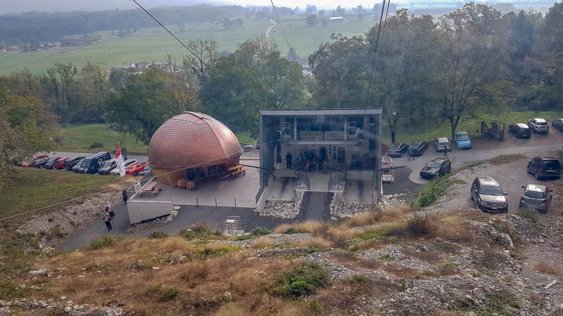
This solar-powered self-service cable car is self-service. So no ticket office. Instead, you buy your ticket at a machine that accepts cards and cash.
Then you scan your ticket at the turnstile, board the cable car and it automatically closes the doors and rides to the top. You don’t need to push buttons or call an operator.

The cable car fits 8 people and takes about 8 mins to go up the mountain. Officially, it runs every 20 mins, but on busy days, it runs continuously.
We were behind a large group going up for lunch, so we had to wait about 1 hour in line. I can’t say what’s normal. In any case, probably best to go early in the day. We couldn’t find a WC at the valley station, but there’s one at the restaurant at the top.

2. Arrival at Staubern viewpoint
The cable car drops you off at Berggasthaus Staubern shown here.

They have a cafe with indoor and outdoor seating. They have a snacks and drinks you can buy to take on the trail with you.

Very nice views from their terrace overlooking the Rhine valley and mountains beyond.

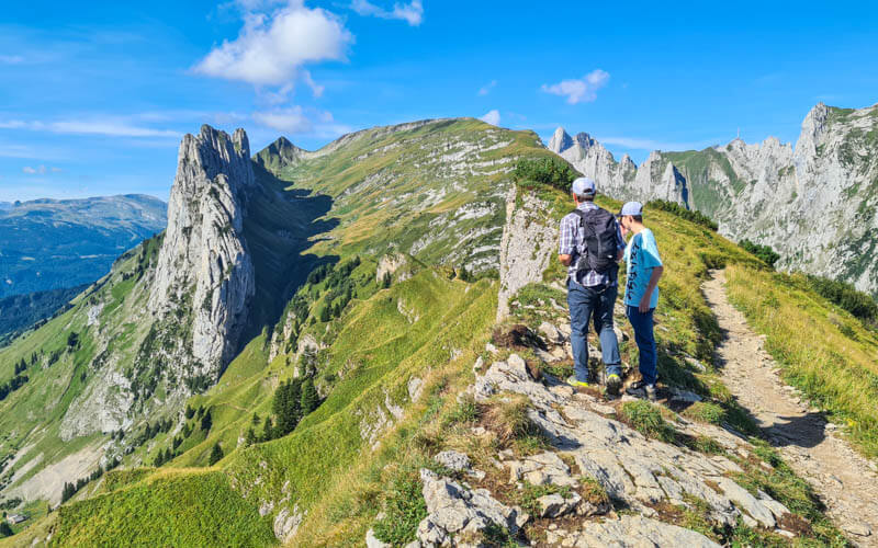
3. Starting the trail
Follow signs to Saxerlücke, starting behind the restaurant.

There is also a trail leading east along the ridge to Hoher Kasten. You can do that next time.

Just a couple minutes after leaving Staubern, you’ll walk over some stairs to reveal this view. The lake in the far distance is the Fälensee.

The trail starts off very rocky with steep steps and a section cut into the side of the cliff.

There are some stairs and switchbacks and a couple places where there are loose rope handrails on the sides of the trail.

The mountain often slopes off steeply on one side of the trail, but it is not a cliff drop-off.

Lots of rock, some dirt.

Looking back on the trail

All the feels!


When you come out of the shade, you get a view of the famous peaks. Anywhere along here would be a nice place for a picnic.
Continue walking down the trail to get closer to the peaks.

How this trail looks in late October when the grass has turned golden brown.

This is my favorite place for pictures with the peaks.

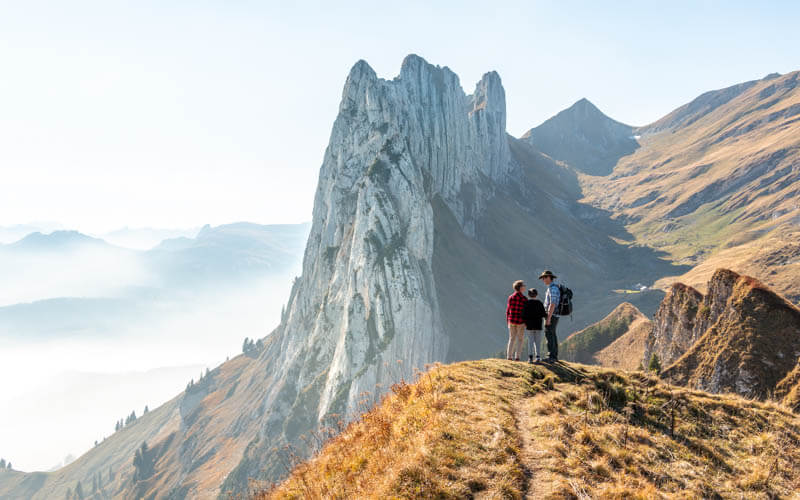
Besides the Saxer Lucke peaks, you have great views of many other mountains in the Alpstein range.

There are a couple info boards talking about the geological formations.

The trail winds down to your right, obscuring the view for a bit.

Then you come around the corner to this view.

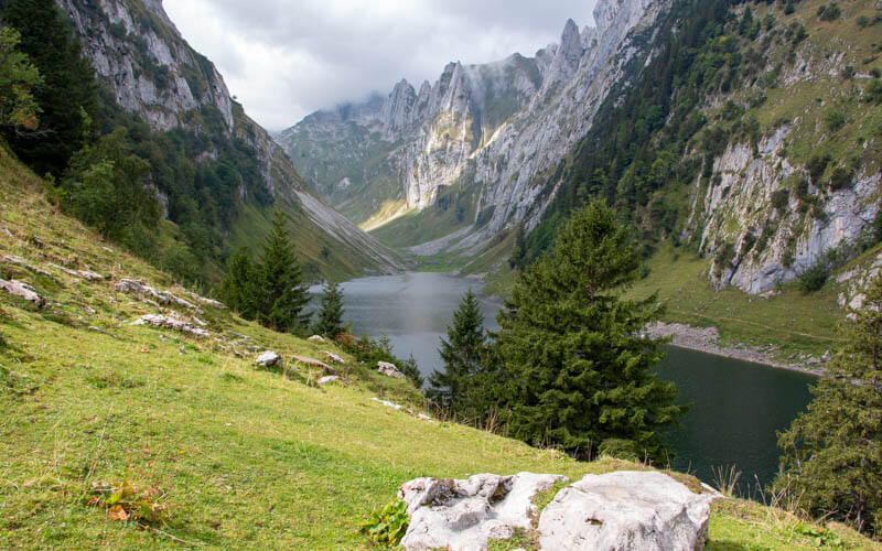
4. Hike down to Fälensee lake & Bollenwees restaurant
If you are done, simply hike back the way you came to the cable car.
But if you have the time and energy, I highly recommend hiking down to the Fälensee lake and Berggasthaus Bollenwees hotel/restaurant for lunch.
From this sign, follow direction Bollenwees. It’s about 20 mins down to the restaurant and lake.

The switchback trail shown here leads down to the restaurant.

Here is the lovely Fälensee lake.

There are a couple picnic areas with fire pits along the lake. Lots of people picnic here.
5. Bollenwees Guesthouse
We always look forward to eating at the Bollewees restaurant.

The Bollenwees menu says their rösti is widely considered the best in this region. I would absolutely agree!
It’s the crispiest rösti I’ve ever had. I think they must deep fry it. It’s rich, so I suggest not adding cheese and perhaps splitting it with a friend.
6. Hiking back to the Staubern cable car
When you are done eating, return the way you came, hiking back up to the Saxer Lücke viewpoint. Then continue on the trail back to Staubern. Making our way back along the ridge.

Looking at Hoher Kasten on our way back. For a longer hike, you can start at Hoher Kasten and hike the Alpstein Geological Trail to Staubern before joining this trail.

Back at Staubern, ride the cable car down the mountain. In the afternoon, there can be long wait since capacity is only 8 people. So if you have a tight connection for public transport, give yourself a little buffer time.
FAQ
Can I bring a dog on the Saxer Lücke trail?
Yes, dogs are allowed on this trail but should be on the leash for the safety of other hikers and the dog. Dogs require their own ticket on the Staubern cable car.
Can I hike the Saxer Lücke trail on a rainy day?
I do not recommend hiking this trail on a rainy day or shortly after rain. There are some sections with a steep slope on one side. The rocky terrain and/or stairs that can be slippery and dangerous when wet or with ice if overnight temperatures are cold enough.
Is the Saxer Lücke trail possible in winter?
No. The Saxer Lücke trail is covered in snow in winter and is not maintained as a winter trail. The trail is usually open from May to October. However, the Staubern cable car and hotel/restaurant are open in winter so you can enjoy the views, even if you cannot hike.
Is the Saxer Lücker hike possible with baby strollers or wheelchairs?
No. This trail is not obstacle free and not suitable for strollers or wheelchairs.


24 responses
I had a small suggestion for the Saxer Lücke hike post: we went there yesterday and it was super crowded. We had to wait over an hour just to get on the cable car to Staubern. On the way back, I thought it would be better, but we ended up waiting another 45 minutes. There are two cable cars, each with a capacity of 8 to max 10 people, and one ride takes about 8–10 minutes — so it works out to roughly one person per minute. We timed it both ways and it was pretty consistent.
Also, just had to say — your Rösti recommendation was a 10/10! Honestly the best we’ve ever had. We thought about sharing one portion, but couldn’t resist ordering two. Zero regrets.
On the return hike, instead of going back the same way, we took a slightly different route via the alpine meadows for a bit of variety. It was very doable, with an approx. 350m elevation gain at the end. For some reason, the signs don’t mention that this way leads to Staubern, but it does work out — the trail passes a few farms and we even saw a deer, along with other animals. A really lovely stretch.
Thanks for the helpful trip report. I’ve also had the experience of long waits for that cable car. Much better if you can manage visiting on a weekday. Glad you enjoyed the Rösti!
Hello Tanya!
Very informative and helpful blog, I already saved a lot of your posts.
What do you think, this hike is suitable with a 10 months old toddler? Of course, he will be carried.
Thank you!
If you are carrying the toddler, you could hypothetically go anywhere. It’s not particularly dangerous on this one. Have fun!
Hey Krisztina,
I hate to disagree with Tanya, she is the expert for sure, but I just went yesterday with a friend on this hike and there are maybe 2-3 short portions where I found this hike so tricky, I had to go down litteraly on my knees and hold on with my hands, to make sure I do not slip. I’d be afraid to carry a baby and do these movements.
Maybe I am not fit enough, idk, maybe you have more experience but in my opinion this hike is not for people carrying babys. I only saw 1 dad with a baby mountain carrier and he managed well so it depends on experience I guess.
Thank you for sharing your experience! I’m sorry to hear that you had a difficult time on this trail. I will surely update my description to include more helpful descriptions of the terrain so others may be better informed and prepared for the conditions. I agree that some sections do have very rocky terrain with stairs and tall drops that have to carefully managed to avoid falling. Some of the rocks have a slippery texture, making it more difficult find stable footing. This is extra tricky if you are carrying a baby in a backpack, where you weight distribution is uneven.
For anyone considering this trail, I definitely recommend using trekking poles, especially when carrying a baby, to help with the stability.
Thanks again for taking the time to leave this comment and help everyone be more safe on the trail.
Hi there!
You website is so helpful – thank you so much for all the detail and photos!
I was hoping you could provide me with some guidance in regards to travelling between Schafler Ridge to Saxer Lucke hikes. I would really like to do the Schafler Ridge hike and then stay in the Schafler Ridge hut over night and then the next day make my way to the Staubern hut to stay the night and to do the Saxer Lucke hike.
I’m struggling to work out the public transport between the cable cars I will need to get to for each hut/ hike. If you don’t mind, could you please advise or point me in the right direction? I will not have a car.
Thank you so much,
Belinda
These places are unfortunately quick far from each other even though they are very close. If you are at the Schäfler hut, then you should probably ride the Hoher Kasten hut up to the ridge and do the long hike over to Saxer Lücke. That is described in this post. It’s a very long hike, but the public transport is much more straightforward than trying to get to the Staubern cable car for the short hike to Saxer Lücke. https://swissfamilyfun.com/hoher-kasten-alpstein-geological-trail/
The best info and summary I found. Very detailed information, logically presented. Thank you!
Hi,
Thank you very much for this amazing post. We did this hike last week and your post helped us a lot planning our day.
Hi there,
Thank you for this post. Would it be a good ides to hike this trail around October?
Thanks,
Jessica
I’ve done that trail in late October and it was very beautiful. Just make sure to check the status of the trail. You should not hike it with snow or ice.
Thank you very much for this post, I found it very helpful in planning my trip to Saxer Lücke!
So glad to hear you had a good time and that my post was helpful. Yay!
Hi, can you make a loop, instead of heading back from Falensee to Saxer Lucke and back to Staubern, from Falensee, take the other trail that leads back to Staubern.
Thank you.
Yes, there are other trails that lead back up to Staubern. But they look rather steep and exposed. I haven’t done them myself so I can’t say anything about them.
Just did this hike yesterday from Staubern to Saxerlucke (and back) but unfortunately didn’t see the big mountain due to the clouds around it. It was a beautiful hike though with our 10 month old cocker spaniel. Your post helped us plan the day!
Glad I could help! Hope you can visit another time and see those peaks. They seem to like to hide, just like the Matterhorn.
Do you think that it can be done with one year old who is in carrying backpack?
Yes, you can do this hike carrying a child in a child carrier backpack. My friend did this a couple weeks ago and really enjoyed it.
Hi there… this looks like a great hike; however, it could also seem a bit short. You mentioned that at some point, you could have taken the switchbacks down towards the Falensee lake, but you chose to end your hike there because you didn’t want to hike back up the switchbacks. I would really love to go to the lake, but considering that I am taking my dad with me, it seems that it would be too large of a hike to continue all the way to Brülisau. So, I was wondering how much longer would it take or difficult would it be, to hike down to the lake and then hike back up the switchbacks from there, in order to return to the original point?
Thank you very much!
Hi. I keep wanting to hike down to the lake too, but it’s not so convenient. If you take the Staubern lift and want to return to that lift, you will have to hike back up in any case. From the Saxer Lücke viewpoint, it’s about 1.2km and 220m of elevation descent down to the Falensee. You could hike back the way you came or hike back a different way to Staubern, which I’ve marked on this trail map. https://www.gpsies.com/map.do?fileId=qrcnvdwiigxzaddx This loop is about 8.2 km and about 460m elevation up and down over the course of the hike. I haven’t done that second part of the trail. If you do it, let me know what you think.
Great Hike! But please note that the cable car service has been interrupted due to yesterday’s accident! https://www.20min.ch/schweiz/ostschweiz/story/Seilbahn-stuerzt-12-Meter-zu-Boden-24683950
Yes, I just saw that story, very scary! I added a note to the top of this post with a link to the story. Thank you. Hopefully they will have the lift in good working order before next hiking season. And thankfully no one got hurt and this kind of accident rarely happens in Switzerland.