Appenzell is a spectacular region in eastern Switzerland known for the impressive Alpstein mountain range, rolling green hills spotted with adorable villages and its signature cheese. The most famous hikes in this region are more suited to risk-taking mountain climbers. But there are many beautiful trails for casual hikers and families, as outlined below.
Contents
1. Berggasthaus Aescher – famous cliff restaurant
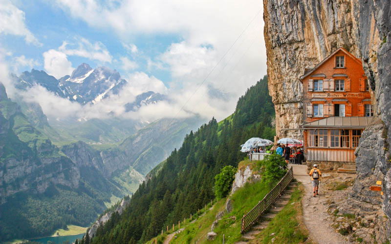
You’ve probably seen a picture of this famous cliff restaurant on social media. It’s easy to reach, starting with a cable car ride up the mountain. Then a short 20 min walk down through a cave and around the cliffs on an elevated wooden walkway. On the way, you’ll pass a hermit’s hut and wild church, an interesting look at Swiss history and culture.
It’s not a difficult or dangerous hike, but it does have uneven terrain and sometimes slippery surfaces inside the cave. So children or anyone with mobility issues may need some assistance.
The restaurant doesn’t take reservations, so come early and prepare to wait for a table. But the view is definitely worth it.
Hike stats: Easy • 1 h • 2 k • 180m • 150m
See details for Berggasthaus Aescher trail
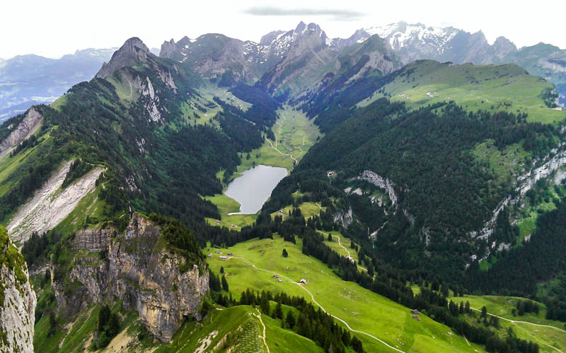
2. Seealpsee lake

You can see this gorgeous alpine lake from the cliff restaurant. If you want to get close, you’ll need to hike about 1 hour down from the restaurant to the lake. It’s a narrow dirt trail with switchbacks, stairs, and steep slopes on the side of the trail. So this best for those with experience hiking and sturdy shoes with good tread.
Hike stats: Moderate • 3.5 h • 7.7 k • 130m up, 840m down
Alternatively, you can walk up from the valley on a service road, which is a bit steep but easier and safer terrain than the mountain trail. Plus it’s free because it doesn’t require the cable car ride.
At the lake there are a couple hotels and restaurants. Many people picnic along the lake shore, building fires and grilling up sausage. We like to rent the rowboat and explore all the corners of the lake. At the end of your day, it’s a long hike down the valley to your starting point.
See details for Seealpsee lake hike
3. Schäfler Ridge

From the same cable car used to reach the cliff restaurant, you can take a different trail up the mountain to the Schäfler mountain hut. From here, you can admire the impressive Schäfler ridge shown above. Casual hikers and children can do the first part of the hike to the viewpoint and perhaps enjoy a traditional Swiss meal at the hut.
Experienced hikers that aren’t afraid of heights can continue slow and steady along the cliff’s edge. You follow the ridge for about 1 km, then the trail branches in several directions. Most casual hikers traverse back to the cable car or head down to the Seealpsee lake. More adventurous hikers may continue to Mesmer hut or even all the way to Mt Säntis (safety harnesses recommended!). In any case, this hike will definitely take your breath away.
If you’re lucky enough to get a reservation, I’d suggest staying overnight at the hut to enjoy sunset and sunrise over the mountains, then get an early start on the rest of the hike.
Hike stats: Challenging • 3.5 h • 7.7 k • 460m up, 490m down
See details for Schäfler ridge hike
4. Saxer Lücke – the easy way from Staubern

These Instagram famous spiky peaks aren’t nearly as difficult to reach as you might imagine. You start by riding self-service solar powered cable car to the Stauben mountain hotel. Then hike about 3 km on a rocky path traversing the mountain to the viewpoint.
The peaks can be elusive as clouds like to hang close. So pick a very clear weather day if possible. You can simply walk return the way you came or hike a bit further to have lunch by the Falensee alpine lake.
Hike stats: Moderate • 2.5 h • 6 k • 240m up/down
See details for Saxer Lücke easy hike
5. Hoher Kasten geological Alpstein trail (the long way to Saxer Lücke)
If you want to see all the things on a longer hike, start at Hoher Kasten instead and follow official trail 988 – Geologischer Wanderweg Alpstein. You start by riding a cable car up to Hoher Kasten at 1794m. Then you hike along the ridge about 8km to reach the Saxer Lücke viewpoint, passing the Staubern cable car and hotel on the way.
Then hike down to the beautiful Falensee lake and Bollenwees guest house for lunch (perhaps an overnight if you are lucky enough to get a reservation. Then down the rest of the mountain, with some steep descents mocking your knees.
Hike stats: Challenging • 5hr30 • 16 km • 640m up, 1500m down
See details for Hoher Kasten geological Alpstein trail

Even if you don’t want to hike, a ride up to this mountain is worth it just for the views. As described above, this is the starting point for the long trek over to Saxer Lücke. But hiking the other direction leads you to a hidden alpine lake and many other charms as you make your way down the mountain. For a little excitement, you can rent a kick scooter at the mountain hut and ride the last 3 km down to the valley.
Hike stats: Moderate • 3.5 h • 9 k • 150m up, 570m down
See details for Hoher Kasten hike
7. Kronberg

If you are traveling with children, Kronberg is a great choice. Besides fantastic views, they have lots of fun amusements for young and old, including an alpine coaster, large adventure rope park, and big playground. The snow melts earlier here, meaning you can usually visit Kronberg already in May while other mountain trails are out of service.
If you want to hike, the trails are very safe (no drop offs!) with gorgeous views of the Alpstein mountains, framed by lush green meadows bursting with wildflowers. For children, they have a great playground, alpine coaster, and ropes park near the valley station.
Hike: easy • 3.5 h • 9.7 k • 30m up, 870m down
See details for Kronberg
8. Mt. Säntis viewpoint

You can visit this mountain peak any time of year by simply riding a cable car to the top. This outing is not a proper hike, rather a short wander around the observation decks on the top of the mountain. This is a great way for non-hikers to enjoy the big views that usually only mountain climbers can enjoy. If you are tempted to follow the trails leading from the top, read about the Lisengrat hike below.
See details for Mt. Säntis
Advanced hikes
The following Alpstein hikes are popular with more extreme hikers that don’t mind some risk for a reward. These should only be done by experienced hikers that are familiar with Swiss hiking and accept the inherent risk. I haven’t done these hikes, so I can’t offer my opinion on the difficulty or danger. Before planning your trip, please research these hikes thoroughly, carefully consider the risks, and only attempt in dry conditions with no forecast of rain.
9. Alpstein Three Lake Hike

This trail visits three alpine lakes in the Alpstein region: Seealpsee, Falensee, and Samtisersee. Each of these can be visited with the easier hikes listed above. But combining them makes for an exciting all-day adventure.
The section after Seealpsee near Megisalp has some steep, rocky terrain, which some hikers may find too challenging and a little scary. But this is still a red/white trail, suitable for most experienced hikers that aren’t afraid of heights.
Hike stats: Challenging • 6hr45 • 17.6 km • 1194m up, 1142m down
See details for the Three Lake Hike
10. Lisengrat ridge to Mt Säntis

The famous Lisengrat ridge stretches between Säntis (2502m) and Altmann (2435m), the two highest peaks in the Alpstein range. Many trails lead here. The official Swiss trail is the 951 Gamplüt-Säntis-Weg, which climbs 1500m over 10 km to reach the Säntis peak. But most blog reports I’ve read hike up from either Wasserauen or Brülisau/Bollenwees. I found the photos on TravelMuseFamily.com helpful.
The Lisengrat ridge section is “protected” with many cables, chains and ladders built into the rock. Signs recommend that you wear a safety harness and clip in where possible along the route. But most hikers do this trail unprotected, using caution and hoping for the best. Obviously, this trail should only be done by very experienced hikers who are not afraid of heights.
Many choose to divide the hike over two days, staying in one of the mountain huts along the way. This helps keep your body and mind fresh for the difficult parts of the trail. Also, cable car and buses don’t run late in the evening, so it can be difficult to fit the whole hike into one day without starting extremely early.
On The Amazing Race TV show, contestants did a short 1km section from Mt. Säntis down the ridge and back up. They were accompanied by guides and protected by safety harnesses secured to the cables.
See details for the Gamplüt-Säntis-Weg


