
This trail showcases the Alpstein mountain range in the Appenzell region, known for its impressive geological formations and spiky peaks.
Starting at the Hoher Kasten peak, the trail follows the ridge leading to the famous Saxer Lücke viewpoint. Along the way, you’ll find many info signs explaining the geological features around you.
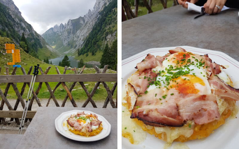
Then you descend to the idyllic Fälensee alpine lake, where you’ll find the Bollewees mountain hotel, which has best rösti in Switzerland. Lastly, a long descent through alpine meadows and forests until you return to the bottom of cable car where you started your day.
Keep reading for all the info you need to plan your hike here.
| Region: | Appenzell, Northeastern Switzerland |
| Starting point: | Hoher Kasten cable car – Dorf 22, 9058 Brülisau |
| By car: | Parking GPS: 47°17’48.4″N 9°27’23.2″E 1hr20 from Zurich |
| By public transport: | Bus stop: Brülisau, Kastenbahn 2hr10 from Zurich HB |
| Trail: | 16.4 km • trail map |
| Time: | about 6 hours |
| Difficulty: | difficult |
| Condition: | mountain trail, uneven terrain, stairs |
| Elevation: | highest point 1791 m |
| Open: | mid June to mid-October |
| Cost: | Cable car one way – CHF 28/adult No discounts with Swiss travel cards |
| Extras: | restaurant, mountain scooter |
| More info: | www.hoherkasten.ch • forecast • webcam |
Gallery


Trail map
In Brülisau (1), you board the cable car and ride up to Hoher Kasten (2). Then follow trail signs to Staubern (3), where you’ll find a mountain hotel and restaurant (and toilet). This is also the cable car station where people can ride up for a shorter hike to Saxer Lücke.

Keep following signs to the Saxer Lücke viewpoint (4). Then down to the Bollenwees mountain restaurant and Fälensee (5). Then follow signs to Brülisau, walking down to a long alpine valley on a service road. At the Sämtisersee lake, you can continue on the road back to Brülisau. Or optionally fork right and hike to Ruhesitz (yellow line to 6) to rent the mountain scooters and ride down.
Here is an interactive trail map that you can download on your phone. The trail is well signed and easy to follow.
See trail on Komoot • SchweizMobil • OutdoorActive
Variation with mountain scooter
I think the last 4 km after the Sämitsersee is quite miserable, with a long descent on a steep gravel road, which is slippery. I really hated that part.
I have a better idea that I plan to do next time. After Sämitsersee, follow signs to Ruhesitz, which is a mountain hut where you can rent kick scooters to ride down the mountain. I’ve ridden the scooters after a different hike in this area and it’s definitely more fun than walk down that last bit.
In this case, the trail is slightly shorter at 15.6. See alternate trail map.
You’ll need CHF 16 (bring cash) to rent the scooters. I’d check the Ruhesitz website to make sure the hut is open so you don’t show up hoping for the scooters, see that it’s closed and end up having to hike down anyway.
How to get there
Hoher Kasten is located in eastern Switzerland, near Appenzell.

You can reach the top with the Hoher Kasten cable car – Dorf 22, 9058 Brülisau. Note that there are two cable cars in Brülisau, so make sure you are at the main one: Hoher Kasten, not Sigelbahn.
By car:
The cable car is located at Dorf 22, 9058 Brülisau, about 10 mins south of Appenzell. There is a large parking lot next to the cable car station. This is a very popular area so the parking lot can fill up quickly on weekends.
By public transport:
The Brülisau, Kastenbahn bus stop is directly at the Hoher Kasten cable car station. From Zurich, it takes about 2 hours. From Appenzell, it takes about 12 mins.
Planning your day
Tickets
For this hike, buy a one-way ticket up the cable car. In 2024, it costs CHF28/adult. Children under 16 ride free.
No discounts for Swiss travel cards. Free with regional guest cards: Appenzell Card, Oskar Guest Card, and Bodensee Card PLUS
If you plan to rent a trotti scooter at the end of hike, you’ll need an additional CHF 15 per person (in cash) when you get to the Ruhesitz guest house later on the hike.
Opening Times
This trail is usually open from mid June through October. The cable car runs every 20 mins from 8:00 – 17:00. It opens a little earlier in summer and opens a little later in fall.
We suggest starting this trail as early as possible in the day since it’s so long.
Check Hoher Kasten website for current opening times and trail status.
Photo story of the trail
We did this trail the first week of July 2020. Some of these pictures are from other hikes we did in the same area.
Riding up to Hoher Kasten
We took the train and arrived for the first cable car of the day at 7:20.

This is the panorama terrace at the top of Hoher Kasten.

There’s a short metal walkway that loops around the top. This is not your trail.

View from Hoher Kasten to the east

Starting the trail
Your trail starts on the east side of the peak. There are many trail options, so make sure you follow the right one. You should follow signs to Staubern.

The trail starts down the south side of the peak, then wraps around to the north side.

The trail skirts under the pea. This part is a little exposed, but not terribly dangerous.

Looking toward the lake we’ll hike to later with the Hoher Kasten cable car in view.

This beginning of hike has some of the best views of the Alpstein. Make sure you take pics here before you descend further. A lot of the “ridge” on your way to Staubern is in the forest, so you don’t have this view the whole time.
You can see the Sämtisersee lake below, not the Fälensee lake yet.

Looking back at Hoher Kasten. We’ve descended a lot of elevation quite quickly.

The trail sometimes has views down toward Liechtenstein and Vaduz.

Lots of up and down in the forest.

Looking back to Hoher Kasten after 1h15 of hiking.

Arriving at Staubern
After about 2 hours, you’ll reach Berggasthaus Staubern, a mountain hotel and restaurant. This is also the Frümsen-Staubern cable car station, for those wanting to do a shorter hike to Saxer Lücke.
We like to stop here for a coffee and cake before moving on. They have toilets and you can buy water if you need it.

Looking back at Hoher Kasten from Staubern.
From Staubern to Saxer Lücke
Right after Staubern, it gets very rocky for awhile, with some rocky stairs and a fenced part along the cliff as shown here. You need steady footing and caution but it’s not extremely dangerous.

The trail winds along the side of the mountain as shown here.
Looking back on the trail.

Now the Saxer Lücke peaks come into view. Plan to move through this section slowly so you can take a lots of pics. It’s the best part of the hike.
My favorite photo spot is on one of these little hills before you get very close to the peaks. Send your friends ahead so you can zoom in.
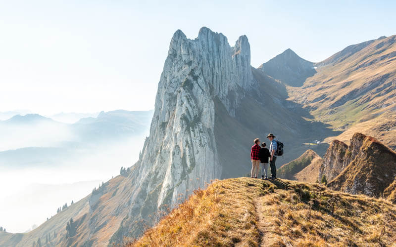
The rest of the Alpstein peaks are very nice too.

It is a the “Geological Trail,” so here’s one of the many info boards talking about that.

The trail leads very close the peaks, with some switchbacks going down below them.

Down to Fälensee lake
Saxer Lücke is actually the saddle just below the peaks, not the name of the peaks themselves. When you arrive at the saddle, you’ll see this trail sign. You are now following signs to Bollenwees (the mountain restaurant) and Brülisau (your starting point).

Now descend some rocky switchbacks for about 25 mins. There’s a lot of loose rock on this section, so be careful.

The trail leads to the gorgeous Fälensee lake. Many people picnic by the lake.

Next to the lake (on the trail), you’ll find the Berggasthaus Bollenwees, a mountain restaurant and hotel. We definitely recommended it for lunch. But it gets very busy so you might want to grab a table before taking your lake pictures.

They advertise the best Rösti in Switzerland and I agree. It’s amazing! But don’t get it with cheese, it’s just too rich that way. I like it with speck and fried eggs. It’s so filling, you could definitely share with a friend.
Now time to take your lake pictures. There is a trail leading along the lake into the mountains, but you won’t have time for that today.
Different mood on a cloudy day.

There is a another hut above the lake, the Hundsteinhütte. Perhaps stay overnight here so you can explore the area more.

Hiking down
From Bollenwees, now follow signs to Brülisau, which is a service road directly behind the hut leading into the long alpine valley.
We followed a different trail because I wanted to be on a walking path not a road. But in retrospect, it wasn’t better. We descended some rocky switchbacks into the valley as shown here, not amazing. After this part, the trail connects back with the service road.

Tough going on these switchbacks, you can skip this by staying on the service road instead.

Exiting the forest and connecting back to the service road through the valley.

Here’s the service road. Feels a little anticlimactic after all the drama on the first half of the hike.

Nice views above us.

Lots of cows here in summer.

You can buy local cheese at a couple dairies along the way.

Another restaurant along the way, but wouldn’t be my first pick as Bollenwees has much better views.

Trail forks at Sämtisersee lake
Now we arrive at the Sämtisersee lake, which appeared in many of our pics taken from Hoher Kasten, which you see in the distance here.

Right after this lake, you enter the forest and follow signs to Brülisau, mostly on a gravel road, pretty miserable in my opinion.

Alternatively, you could fork right, following signs to Ruhsitz (sometimes spelled Ruhesitz), another mountain hut. There you can rent kick scooters to ride down the mountain. Looks more fun, doesn’t it? See that trail map.

Since it was my first time on this trail, I wanted to follow the official route, for research purposes. Wow, did I regret that decision for the next 45 mins. The picture might not look so bad, but that gravel road was terrible. It’s very steep in parts. We were walking super slowly, sometimes side stepping to avoid slipping. Even then, I slipped a couple times and fell once.

Eventually the misery ended and we spilled out into the meadows again. You’ll continue on the road past this other cable car and finally reach your starting point at Brülisau. That takes about another 20 mins, not the most inspiring part of the journey.

Final thoughts
I had a great time on this trail. But I don’t think you get a significantly better experience doing this long trek compared to the shorter Saxer Lücke trail from Staubern. In fact, the whole second half of the trail from Bollenwees to Brülisau is pretty average.
The main reasons to do this trail is if you are staying in the Appenzell region, because the Hoher Kasten cable car is nearby. The Frümsen-Staubern cable car is on the completely other side of the mountain and would take a long time to reach. Hoher Kasten is also much easier to reach by public transport. Also you may just want a longer hike.
Have fun out there!


