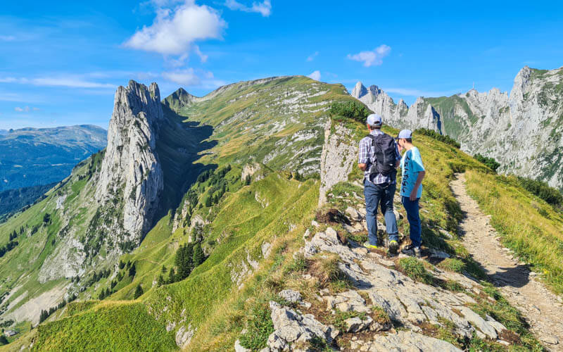
This spectacular ridge trail loops high above the Malbun alpine village in Liechtenstein.
The trail leads to the Augstenberg peak and Pfälzer mountain hut, nice place for lunch or at least a cold drink. Then you traverse other side of the mountain and loop down through lush meadows back to Malbun.
It’s a challenging hike, with lots of uphill, switchbacks, stairs and uneven terrain. It also has a few exposed areas with steep slopes to the side. Best for those with hiking experience and a head for heights.
| Region: | Malbun Liechtenstein (near border of eastern Switzerland) |
| Starting point: | Malbun-Sareis chair lift |
| By car: | Parking lots just as you enter Malbun – see on map From Zürich 1hr20 |
| By public transport: | Bus stop: Malbun, Zentrum From Zürich 2hr10 |
| Trail: | 10.4 km loop |
| Time: | about 4 hours |
| Difficulty: | challenging • 480m up, 830m down |
| Condition: | narrow dirt path with uneven terrain, steep slopes to the side |
| Elevation: | highest elevation 2320m |
| Open: | July to mid October |
| Cost: | budget No discount with Swiss Travel Cards |
| Extras: | mountain hut at halfway point |
| More info: | Malbun Bergbahnen website • webcam • forecast |
Gallery


Trail map
This hike starts at the top of the Malbun chair lift and follows the ridge to Augstenberg peak. Then descends to the Pfälzerhütte mountain hut, the halfway point. Then traverse the mountain, looping back down to Malbun. You could also do this trail in reverse.

See trail map on Komoot • SchweizMobil • OutdoorActive
If you prefer not to pay for the chair lift, you can hike up to the trail as shown on the SchweizMobil trail map.
How to get there
By public transport
From the Sargans, Bahnhof train station, take Bus 11 to Vaduz, Au. Then Bus 21 to Malbun, Zentrum. From Zürich, it’s a journey of about 2h10.
Even though part of the journey is in Liechtenstein, you can still purchase your transport tickets via SBB.ch or SBB mobile app.
By car:
You can drive directly to Malbun and park near the chair lift – see parking on map. Last time we went, the parking was free.

Note that the road from the Liechtenstein valley up to Malbun is a winding mountain road. But the road is well built and mostly two lanes the whole way. Not a particularly difficult drive.
Planning your day
Tickets
To reach the trail, you ride the chair lift from Malbun to Sareis. In 2024, a one way ticket costs CHF 10.30/adult.
No discount with Swiss Half Fare, GA or Swiss Travel Pass.
Opening times
This trail is usually open (free of snow) from July to mid October.
The chair lift runs from mid June to mid October, daily from 8:30 – 17:00 (from 8:00 on weekends). See current opening times.
Photo story of trail
1. Riding up the chair lift
Chair lift station in Malbun. You can buy your one way ticket here – cash or card. The chair lift fits four people.

Looking back at the chair lift station as we ride up.

View of Malbun village from the chair lift.
View down to Malbun from top of chair lift.

2. Starting the trail
Start of trail from the chair lift.

Follow the green 955 trail and signs to Augstenberg and Pfälzerhütte.

Here our trail forks left and follows the ridge. The trail to the right goes back down to Malbun.

The trail starts off pretty easy and wide.

Such a picturesque ridge with lots of great photo ops.
So many attractive nice triangles on this ridge.
3. Climb to Augstenberg peak
The trail is pretty easy until you reach this sign, which warns you not to continue unless you have appropriate hiking shoes and clothing. After this the trail is definitely more difficult and could be dangerous if you aren’t careful or in poor weather conditions.

Loved the grassy slopes.
Even in late July, there were a few snow patches on the trail.

This short rocky section has a cable hand rail to help you safely navigate this section. It’s not super dangerous, just go slowly.

Looking back on the trail before we hit the rocky climb to the peak.

Here’s the path behind the cliff edge. As you can see, the path is safely set back from the edge, not dangerous if you stick to the path.

View over the cliffs to the Malbun village below.

The last rocky stretch up to the Augstenberg peak.

Here’s the Augstenberg peak. Unfortunately, no guest book to sign.

We took a small break to hydrate before heading on.
4. Descent to Pläzerhütte
After the peak, you descend about 30 mins down to the Plälzer mountain hut.

You start through this lovely meadow, better place for a picnic than the crowded peak.

Winding over and around ridges.

A dusty switchback section, nice to have sticks for balance here.

More descent over lots of loose rocks.

Lots of pretty angles in the landscape.
One snow patch we had to cross. A little slippery so glad we had hiking sticks.

Traversing a grassy slope.

So many great photos to take along the way.
Last bit of ridge before we reach the hut.
Arriving at the hut
Descending to the Pfälzer hut, the halfway point.

Would be a great place for an overnight.

We took a quick break for cold drinks and cake.

The hut menu. Cash only.

5. Traverse back
From the hut, you start on this rather flat wide path below the hut.

Traversing the mountain here is perhaps the easiest part of the hike.

The traverse turns gradually uphill, a long slow burn.

It’s still pretty on this part, but not as dramatic as the first half.

Looking back on the traverse.

6. Descend to Malbun
At this turnstile, the climb is over and now a long descent to Malbun.

The downhill starts with switchbacks through these meadows.

Some stairs.

The path flattens for awhile, giving our knees a break. Straight ahead, we can see the chairlift we took in the morning.

You briefly join a service road, then fork right through this last turnstile. Follow signs to Malbun.

Beautiful flower meadow right before we get to the village.

All done!