This hike starts at the top of Hoher Kasten, a tall mountain peak in the Appenzell region. The trail and winds down the mountain, then loops through a pretty forest to visit a small lake. Then you wander through some alpine meadows to a mountain hut, where you can kick scooter to ride the rest of the way down.
The views are spectacular and the hike is not particularly difficult since it is mostly downhill, a good choice for families.
Contents
| Region: | Appenzell, Northeastern Switzerland |
| Starting point: | Hoher Kasten cable car – Dorf 22, 9058 Brülisau |
| By car: | Parking GPS: 47°17’48.4″N 9°27’23.2″E 1hr20 from Zurich |
| By public transport: | Bus stop: Brülisau, Kastenbahn 2hr10 from Zurich HB |
| Trail: | 9 km • trail map |
| Time: | 3 hours |
| Difficulty: | moderate |
| Condition: | part narrow dirt path, part dirt road |
| Elevation: | highest point 1791 m |
| Open: | mid June to mid-October |
| Cost: | Cable car one way – CHF 28/adult No discounts with Swiss travel cards |
| Extras: | restaurant, mountain scooter |
| More info: | www.hoherkasten.ch • forecast • webcam |
Gallery


Trail Overview
We did a version of the “Family Hike to Forstseeli” trail described on the Hoher Kasten website. After visiting the lake, the suggested trail continues hiking all the way down to Brülisau. Instead, we hiked across to Ruhesitz and rented kick scooters to ride down to Brülisau, which was more fun for everyone.

You start at the Brülisau cable car station (1) and ride up to Hoher Kasten (2), where you find a restaurant and panorama terrace. The trail hikes down the mountain then enters the forest, leading to the Forstseeli lake (3), where you’ll find lots of fire pits and picnic tables.
If you want to ride the scooters, loop back to the dirt road (#5) and follow signs to Ruhesitz Gasthaus (4), where you can rent the scooters. Ride down the paved road about 3km (blue line) to Brülisau. If you don’t want to ride the scooters, just follow trail signs to Brülisau.
See interactive trail map on Komoot. The trail is a little hard to follow, so I suggest having this map on your phone for reference.
How to get there
Hoher Kasten is a mountain located in eastern Switzerland, near Appenzell.

You can reach the top with the Hoher Kasten cable car – Dorf 22, 9058 Brülisau. Note that there are two cable cars in Brülisau, so make sure you are at the main one: Hoher Kasten.
By car:
The cable car is located at Dorf 22, 9058 Brülisau, about 10 mins south of Appenzell. There is a large parking lot next to the cable car station. This is a very popular area so the parking lot can fill up quickly on weekends.
By public transport:
The Brülisau, Kastenbahn bus stop is directly at the Hoher Kasten cable car station. From Zurich, it takes about 2 hours. From Appenzell, it takes about 12 mins.
Planning your day
Tickets
For this hike, buy a one-way ticket up the cable car. In 2024, it costs CHF28/adult. Children under 16 ride free.
No discounts for Swiss travel cards. Free with regional guest cards: Appenzell Card, Oskar Guest Card, and Bodensee Card PLUS
If you plan to rent a trotti scooter at the end of hike, you’ll need an additional CHF 15 per person (in cash) when you get to the Ruhesitz guest house later on the hike.
Opening Times
This trail is usually open from mid June through October. The cable car runs every 20 mins from 8:00 – 17:00. It opens a little earlier in summer and opens a little later in fall.
Check Hoher Kasten website for current opening times and trail status.
Photo story of the trail
The photos here are from our hike at the end of June 2015. At the time, my kids were aged 6 and 9. Sorry for the image quality, my camera wasn’t amazing at the time.
Top of Hoher Kasten
At the top of the cable car, you’ll find a large complex with a restaurant, gift shop, bathrooms, and a large outdoor viewing area, shown below:

The restaurant is open year round and slowly rotates so you can enjoy the entire 360 panorama over an hours time. There is a short loop trail around the top, Europa-Rundweg, but it is under construction in 2015. You can see pictures of the construction and get more info here.

If you walk around the complex, to the northwest, there are some benches and a couple fenced viewing platforms so you can safely enjoy the view with your children.

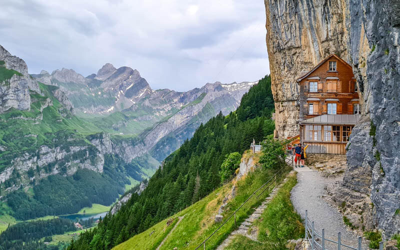
Below is the view from the platform. There are several challenging hikes in this area, with a couple mountain huts for overnights near the lakes. Those hikes start with tricky ridge hikes, not suitable for very small children. Your hike begins in the opposite direction.

Starting the trail
After exiting the Hoher Kasten cable car and building, turn left and you’ll see this yellow trail sign pointing down some stairs. You’ll be headed to Kamor.

In these pics, you can see the trail cutting across the mountain to the right.

Descending the peak.
After descending the peak for a few minutes, you’ll reach this fork in the trail. Take the fork to the right, following signs to Kamor and Resspass.

The trail cuts across a lovely meadow.

It’s fun to look back and see the tall peak where you started.

A few minutes later, the trail joins a paved road. I was worried that we took a wrong turn and I wasn’t so happy to be on a road.

But don’t worry. After a few minutes, the trail leaves the road again and cuts across the fields as shown below. Just watch for the red and white trail markers.

The trail continues down, occasionally crossing the paved road.

We were happy to have our hiking sticks on this part. It’s very rocky with some tricky footing. We were there in late June and there were also lots of cows on the trail.
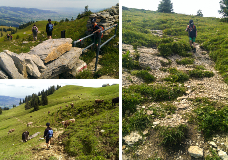
After about 90 mins, we reached the dirt road shown below. Walk straight ahead to the stone wall to take the loop to the Forestseeli lake. After the loop, you’ll return exactly to this point and can then walk to Ruhesitz, by following the dirt road to your left.
Loop to Forstseeli lake
If taking the loop, you’ll see a small sign at the stone wall that points right and says “D’auerschwamm, Forstseeli, Eggerstanden”. This is the beginning of the loop. We chose to first walk right along the stone wall a few meters, then through the cow gate to join the trail, as shown below. We came back on the trail that you see directly ahead of you on the other side of the stone wall.

If you walked right along the stone wall and entered the second cow gate, you’ll be on this gentle trail that rounds the hilltop. It will seem at first that you are way off course, but don’t worry. The trail will eventually veer left again and head into the forest, about 15 mins from the dirt road. On your way, you’ll pass the cafe shown below before entering the forest.

After passing through the cow gate, the trail enters the forest on a rough path.

The forest was very lush and pretty in late June.

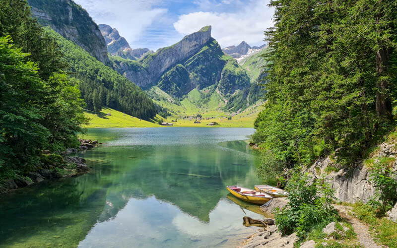
In a few minutes, you’ll reach Forstseeli, the little lake shown below. There are lots of fire pits and picnic areas around the lake.

At the far end of the lake, you’ll find this hut, which only has a small room for shelter, no services, no toilets. It does have picnic tables and a large grill outside. We got caught in a rain storm for about an hour, so this shelter was well appreciated as we waited out the rain.

It has lots of firewood as well. It was quite crowded on the Saturday we were there, so we found an empty fire pit in the forest instead.

When you are ready to leave the lake, follow trail signs to Resspass. There are several trails going every which way, but the Resspass trail will lead you back to the beginning of the loop. About halfway, you’ll see trails splitting off down the hill toward Brülisau. If you don’t want to hike to Ruhesitz for the Kickbikes, take one of these trails instead so you don’t have to backtrack.
The Resspass trail is partially on a dirt road, partially through meadows, with some really steep bits before reaching Resspass, a lookout point on this hill you’ve been walking around.

Here’s the view from Resspass. This would be a nice spot for a picnic.

Looping back to Ruhesitz
Continue on the trail from Resspass through the forest and back to the cow gate and dirt road. Turn right to follow the trail to Ruhesitz. This loop detour is about 3km and took us about an hour of walking time.

The trail is pretty mild from here, through cow meadows and forests. There were tons of cows in late June and we had to loudly herd them off our trail before continuing.

Here’s a view up at Hoher Kasten, where we started this whole thing.

Mountain scooters
The trail joins a paved road at the Ruhesitz Gasthaus. You can rent a trotti scooter, aka Kickbike, here for CHF15/scooter, including helmet.
They recommend that children be at least 12 years old to ride alone, but this was not enforced; it’s a casual operation. The child should be a confident bike rider and able to properly operate the breaks.
Smaller children can ride with an adult, but be warned that it’s a little tricky to manage two people on a scooter. My husband rode down together with my 7 year old and it was fine.


Whew! That was a long one. We had a great time and I hope you do too!


7 responses
Great article!
If I compare this route with “Kronberg Ridge Trail to Appenzell”. Which one is:
– easier and safer to hike with kids not used to hiking?
– walking less in forest? as we are nkt much fond of forest
– better signpost to follow and not confuse?
Why both of them noderate and not easy?
The Kronberg trail is easier. But if you don’t hike regularly, it might be too long all the way to Appenzell. You may prefer the trail from Kronberg that hikes back down to the play area (trail 3). Or just the short loop at the top (1) and spend more time at the play area. See all their trails here: https://kronberg.ch/de/erlebnisse/sommer/wandern.html
Thanks for the live report! Good to know about the closure.
Great article. As I mentioned on the Elm post we got 5 CHF discount for Hoher Kasten and might try to go there soon. Probably we won’t use scooters so instead of turning left at Resspass continue downhill to Bachers and Brülisau. Any idea how long that might take?
It’s about 3.2 km, so probably about an hour. Have fun!
This place is a hidden gem. Beautiful nature and fantastic views. Took us about 5 hours to slowly hike down without scooters. Halbtax also accepted.