Switzerland has an extensive network of mountain huts that makes it easier to explore the alps on foot.
The huts sit along the network of hiking trails, providing a safe place to sleep, meals, and basic comforts in the mountains. Instead of carrying camping gear, food, and everything you need for several days, you can travel from hut to hut with a much lighter pack.
Below, I’ve gathered some of our favorite hut-to-hut hikes in Switzerland, from relatively easy routes for first-time hut hikers to more challenging multi-day adventures.
There are options ranging from a single night in the mountains to five nights on the trail, giving you plenty of ideas for planning your own Swiss hut-to-hut adventure.
See also my Beginner’s Guide to Hut Hiking in Switzerland.
Selecting a hut-to-hut route
Before you pick a Hut to Hut tour, consider:
How long do you want to hike each day?
Many hikes between huts are about 20km with 1000m+ ascent/descent. Even if you can do the distance, the elevation changes add time and difficulty to the hike, stretching hiking time to 6-8+ hours/day, not counting breaks. The shorter tours below still give the authentic experience of hut hiking without a huge commitment.
What is your hiking experience?
If you are a casual hiker, you may find these tours more challenging than you expect. Mountain trails in Switzerland are usually well-marked and well-maintained. But even on a trail labeled “family friendly,” you still you may find yourself climbing over boulders, crossing snow patches, scrambling up scree fields, etc.
What if the weather turns sour?
Weather can move in very quickly in the mountains and create unpleasant and dangerous conditions. For example, heavy rain, lightning storms, thick fog with no views, surprise snow – we’ve seen it all. You may want to plan your tour with a plan B, so you can end the hike earlier, perhaps by hiking out to nearby public transportation if necessary.
Short hikes – 1 hour or less
You don’t have to do a hard hike to have the experience of sleeping in a mountain hut. Below are a few hikes with short hikes, particularly good for beginners hikers and families with smaller children.
Lidernen Hut
The Lideren hut is only a 15 min walk from the cable car station. It’s perched on the side of the mountain, with spectacular views and a remote feeling, despite being so easy to access.
The hut is popular with families, often with lots of little kids staying on the weekends and school holidays. From here, you can do a short hike to the pretty Spilauersee lake for a picnic and cold dip.
Location: cable car at Chäppeliberg, Riemenstalden • Lake Lucerne region
Hike to hut: 15 mins • 540m • +40m
Hut website: lidernen.ch
More about Lidernen hut.
Glattalp Hut
This hut is a short walk from the cable car station. Nearby is the beautiful Glattalpsee lake, with an easy trail around the water. From the hut, we also like the Charetalp trail that visits the stunning Pfaffenkreuz viewpoint.
Hike to hut: 10 mins from cable car
If you want a longer hike, you can skip the cable car and hike up: 2h30 • 4.3km +779m. See trail map.
Ristoro Alpo Campo
This mountain hut is high up on the Val da Camp valley, southeast of St Moritz. You can hike here or ride a mountain bus directly to the hut, making it a great option for families and casual hikers.
From the hut, it’s a short hike to the beautiful Lake Saoseo and Lake Viola, surrounded by mountains and larch trees that turn golden in October.
Location: mountain bus picks up at Sfazù, Fermata, reservation required
Hike to hut: bus drops at hut
Hut website: www.valdicampo.ch
Moderate Hike – Up & Back
These huts are at the end of long valleys, making for a peaceful quiet location. But they are up and back hikes, not well connected to other huts unless you trek over a glacier.
Bächlital Hut
This hut stands on a cliff high above the Bächlisboden, a high alpine flood plain surrounded by tall mountain peaks. It’s a steep and rocky ascent but well worth the effort to reach this peaceful place.
Location: start hike at Räterischboden bus stop
Hike to hut: 2h15 • 4.2 km • +628m -69m
Hut website: www.baechlital-huette.ch
More about Bächlital Hut.
Bergsee Hut
The Bergsee hut sits high above the bright turquoise Göscheneralpsee reservoir. From the parking and bus stop, it’s a steep but short hike directly to the hut. Before going up to the hut, you could hike around the reservoir.
Location: start hike at Göscheneralp, Dammagletscher
Hike to hut: 2h • 3.4 km • +596m
Hut website: www.sac-angenstein.ch
More about Bergsee Hut.
See more of our mountain hut reviews.


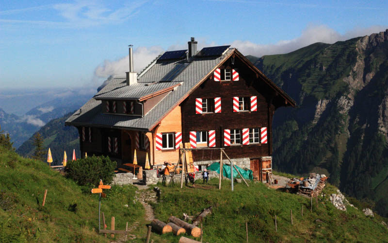
Boval Hut
This hut is located above the Morteratsch glacier, south of St Moritz.
Location: start at Morteratsch train station
Hike to hut: 2h • 3.4 km • +596m
Hut website: www.boval.ch
More about Boval hut.
One Night Tours
If you want the experience of staying in a mountain hut and want to end up somewhere different than you started, I can recommend these.
SponsoredDiscover top exclusive offers today!
Click here to learn more and take advantage of these limited-time deals.
Alpstein: Hoher Kasten > Saxer Lücke > Toggenburg
In Eastern Switzerland, this hike starts at the top of the Hoher Kasten cable car, hikes along a ridge to to the famous Saxer Lücke viewpoint. Then continue hiking parallel to the famous peaks to the Zwinglihütte hut for an overnight. 5h • 13.4 km • +1066m -856m. See trail map.
For day two, hike down to the Falensee lake and Bollenwees guesthouse for lunch. Then continue past the Sämtisersee lake to Ruhsitz, where you can ride a mountain scooter the last 3km down to your starting point. 3h40 • 12.2km +270m -988m. See trail map.
Or hike down to the Toggenburg area, where you can ride the Gamplut lift down to the valley and catch a bus.
Surenen Pass: Brüsti to Engelberg
Starting at Attinghausen cable car, from which you hike up and over the Surenenpass to the Blackenalp hut (8.6km).
Next day, you can hike to the top of the Fürenalp cable car (5 km) and ride down to the valley or hike along the river down to the valley (6 km). This hike is Stage 7 of the Via Alpina trail.
Albert Heim Hut
The Albert Heim hut is near the Furka pass in Graubünden. It has fantastic views of the glacier and a couple small lakes with pretty reflections.

Location: start hike at Tiefenbach bus stop
Hike to hut: 1h30 • 3.5 km +455m
Hut website: www.albertheimhuette.ch
For an easy day two, you can hike back to Tiefenbach via Schafberg. 3.8km +89m -511m See trail map.
Or hike down to Realp, which follows a river thru a beautiful high alpine valley. 6.3km -1011m
Even longer – follow Trail 51 Fürka Höhenweg toward Andermatt instead of hiking down to Realp.
See more info for Albert Heim Hut hike.
Legler Hut
In Glarnerland in Eastern Switzerland, this hike starts at the top of the Mettmenalp cable car and hikes up to the Leglerhütte on the top of the mountain (about 6 km).
This hut is on the top of a mountain with panorama views around the Glarus region, an amazing place to watch the sunrise and sunset. In addition to the mattress bunks, the hut has double and single rooms for more privacy.
This hut is very popular and book out early in the season.
Location: Schwanden train station. Then mountain bus to Mettmenalp cable car and ride up to start of trail.
Hike to hut: 3h • 6.3 km • +885m -205m
Hut website: leglerhuette.ch
For day two, you can loop back to Mettemenalp: 2h • 5.8 km • -700m
More info for Legler Hut Hike.
From Legler hut, there are several other options for day two. You could hike over to Elm Ämpächli, via the Chüeboden lake (3h40 • 9.6km +400m -1187m).
Or hike over Hanenstock and Chalchstöckli to the Obererbs hut, where you can catch a mountain bus. Trail: 4h • 9.8km +532m -1117m. See trail map.
Need help with the logistics? Book a travel consult with Tanya.
Multi-day Tours
Greina Plateau
The Greina Hochebene is a high alpine plateau connecting the Graubünden and Ticino regions of Switzerland. This remote area include meandering rivers, lush meadows, a big suspension bridge, jagged peaks, wildflowers, and interesting geological formations.
We did two overnights at the Scaletta hut and Motterascio huts, which gave us a full day to explore the plateau.
- Day 1: Hike Ghironed to Scaletta hut – 3h • 9.1 km +1067m
- Day 2: Hike thru Greina Plateau to Terri hut for lunch. Then hike to Motterascio hut to sleep. 5h • 14km +66m -695m
- Day 3: Hike down to Luzzano reservoir then down to our starting point. 3h • 10km +105m -1055m
See details for this 3 Day Greina Plateau route.
Another popular option here is along the Alpine Passes Trail, which is a multi-stage trail across Switzerland, connecting many mountain passes. For a one night trip, you could start in Vrin, hike to the Terri hut for an overnight. Then continue thru the Greina Plateau, ending in Campo Blenio to catch a bus. Or continue on route 6 to the next hut at Bovarina.
Need help putting together a route? Book a travel consult with Tanya.
Vier Quellen Weg
A popular long route is the Vier Quellen Weg, or “Four Source Trail”, which visits the source of four main rivers: Reuss, Rhein, Rhone. The full path is 85 km, broken into 5 stages with overnight possibilities at each stop. This well-marked mountain trail is an official Swiss route, labeled #49.
They advertise it as family friendly, but I think this simply means that the trail is well built, not dangerous and doesn’t require technical climbing. But the hikes are still long and very challenging.

Here are the stages:
- Stage 1: From Oberalpsee to Vermigel Hut, 13 km, 800m ascent, 800 descent, 4hr30
- Stage 2: From Vermigel Hut to Gotthard pass, 12 km, 820m ascent, 760m descent, 4hr30. Two small hotels: Ospizio San Gottardo and Hotel San Gottardo
- Stage 3: From Gotthard pass to Campanna Piansecco Hut. 20km, 820m ascent, 950m descent, 6hr
- Stage 4: From Campanna Piansecco Hut to Obergestein village. 20 km, 820 m ascent, 1450 m descent, 6hr30
- Stage 5: From Obergestein to Rhonegletscher, 17 km, 1300m ascent, 400m descent, 6h10
For families that want to do a shorter version of this hike, I’d recommend just doing the first two stages. Or you could just hike to the Tomasee and staying in one of the nearby huts like Badushütte or Maighelshütte.
We have hiked the first part of Stage 1, from the Oberalppass to Lai da Tuma, the lake shown below. I highly recommend this hike even if you don’t do the full hut to hut. Details for this hike here.

We have also hiked part of stage 3 from Gotthard Pass to to the source of the Reuss. Details for this hike here.

Via Alpina Mürren to Oeschinensee
Another popular one I’ve seen online is the Via Alpina trail, combining Stage 12 Lauterbrunnen to Griesalp and Stage 13 from Griesalp to Kandersteg. To save some time and energy, you could ride the bus from Lauterbrunnen to Stechelberg, ride the cable car to Mürren and start hiking from there to Griesalp, where you can stay overnight (about 15 km). Then continue to Oeschinensee and ride the cable car down to Kandersteg (about 14 km). This saves you a couple hours of tough climbing on both sides, but it’s still a very difficult, demanding hike.
We’ve hiked in Mürren and Oeschinensee but haven’t done this long tour. It comes highly recommended but looks very challenging.

I’m currently researching more longer tours and I will add them later.





3 responses
Very well done and helpful
Thanks for publishing this info it was helpful to us, Canadian with Swiss passport who loves the outdoors and married to Indonesian who “grew up in the jungle” and does not want to get into the outdoors.
Glad I could help! Sending positive thoughts about getting your partner on the trail 🙂