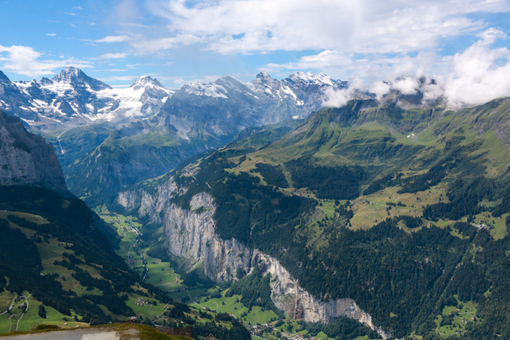
High above the Lauterbrunnen valley, this beautiful trail traverses the mountain with spectacular views of the surrounding peaks.
Starting at the top of the Grütschalp cable car, the path ascends as it wanders through forests and alpine meadows. The trail ends at Allmendhubel, where you’ll find a restaurant, alpine garden, and big Flower Park playground.
If you are hiking with kids, the playground is good motivation to keep walking. For an easier hike, just walk the opposite direction, which is mostly downhill.
This hike is good for those on a budget as the mountain railways are much less expensive than others in the Jungfrau Region.
Quick Info
| Region | Mürren • Jungfrau Region • Berner Oberland |
| Trail start: | Start: Grütschalp cable car End: Allmendhubel funicular |
| By car: | Park in Lauterbrunnen Car Park From Interlaken 30, Grindelwald 35min, Bern 1h, Zurich 1hr50 |
| By public transport: | Lauterbrunnen train station From Interlaken 22 mins, Grindelwald 36 min, Bern 1h22, Zurich 2h25 |
| Trail: | 5 km one way • ⬇️ trail map |
| Duration: | 2 hours |
| Difficulty: | moderate • 400m ascent, 40m descent |
| Condition: | dirt footpath, uneven terrain, Swiss trail rating T2 |
| Elevation: | 1630m – 1940m |
| Open: | June to mid-October |
| Cost 2025: | Mountain transport – Adult CHF 30 |
| Discounts: | Free with Bernese Oberland Pass Discount with Swiss Travel Pass, Swiss Half Fare Card, Jungfrau Travel Pass, or GA |
| Services: | restaurant and playground at Allmendhubel |
| More info: | muerren.swiss • webcam • forecast |
Gallery
Hiking map
To access this trail, you ride the cable car from Lauterbrunnen to Grütschalp cable car. Then you follow the Mountain View Trail to Allmendhubel, where you’ll find the Flower Park playground and restaurant.
Then you can ride the Allmendhubel funicular down to the Mürren village (or hike down), where you can ride cable cars down to the valley, ending in Stechelberg. Then take a bus back to Lauterbrunnen where you can pick up your car or catch a train to Interlaken.
This trail is about 4.8 km and takes about 1hr50 mins to walk.
See trail map on SchweizMobil • OutdoorActive • Komoot
Easier option:
From Grütschalp, you can instead follow the easier trail through Winteregg to Mürren. This version of the trail has only 150m elevation gain.
No hike option:
You can still visit the playground without hiking. From Grütschalp, ride the mountain train to Mürren BLM. Then a short walk through the village to the Allmendhubel funicular, which you can ride up to the playground.
Longer option:
After you finish the hike at the Allmendhubel playground, you can continue on the Northface Trail or Blumental (Flower Valley) trail down to Mürren.
How to get there
This trail is located near Lauterbrunnen and Mürren in the Jungfrau Region.

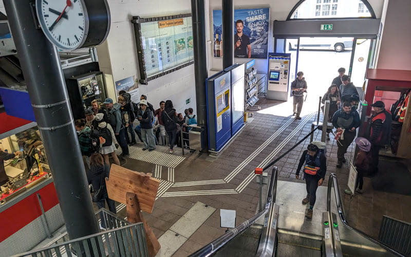
You access this hike from the Grütschalp cable car which leaves from Lauterbrunnen. There is a small Coop grocery next to the cable car if you need to pick up supplies before going up.
By car:
Drive to Lauterbrunnen and park in the metered parking at the south side of town (46°35’32.0″N 7°54’27.7″E). It’s about a 5 min walk back to the cable car (see on map).
By train:
Take a train from Interlaken to Lauterbrunnen train station. The Grütschalp cable car is immediately opposite the Lauterbrunnen train station.
Planning your day
Tickets
At the beginning of the trip, you need a one way ticket on the cable car from Lauterbrunnen to Grütschalp, which costs CHF 9/adult. It runs about every 15 mins and takes 4 minutes. It starts running at 6:13 and ends at 20:35.
The trail ends in Mürren, where you will ride two cable cars down to Stechelberg. This costs CHF 14.20/adult. It runs every 30 mins on the :25 and :55 and takes 15 mins. It starts running at 5:55 and runs till 23:45,
You’ll need to return by bus to your starting point at Lauterbrunnen, which costs CHF 4.40. The bus runs every 30 mins coordinated with the cable car. It runs all day early to late.
Discounts
This whole journey is free with the Berner Oberland Pass, Swiss Travel Pass, GA and SBB Junior Cards. Discount with SBB Half-fare. Children 6-16 half-price, under 6 free. You can pay with cash or credit at the cable car stations.
With the Jungfrau Travel Pass, the Grütschalp cable car and Mürren mountain train are included. So best to return using those instead of the Stechelberg cable car, which is not included.
Photo story of the trail
Riding up the cable car
Here’s the Grütschalp cable car station. You can buy tickets here. But if you have a valid travel pass or ticket, you can just scan the QR code directly at the turnstile.
Stand on the left side of the cable car as you face the mountain. Then you can get this view of the Lauterbrunnen valley as you ride up.

The cable car drops you at Grütschalp. Most people will transfer to the mountain train. But for this trail, exit the station.

There is a small cafe and WC at Grütschalp.

Starting the trail in Grütschalp
To start the trail, start on the wide path that parallels the mountain train line. After 1 minute, fork right onto a trail leading into the woods, direction Allmendhubel. The sign also has a green label “351 Mountain View Trail”.

You start in the forest, quite steep at first with some stairs.


It’s a bit of tough climb for the first 1.5 km, gaining 250m in elevation. After that it’s more gradual the rest of the way to Allmendhubel.

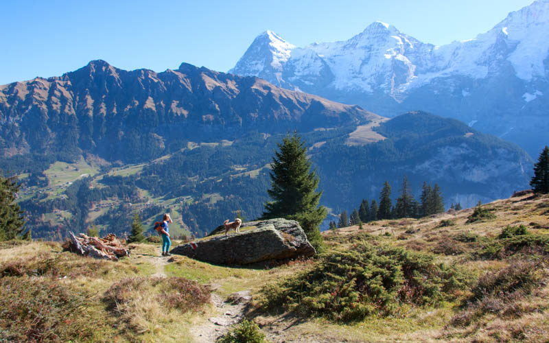
Looking back on the trail with Wengen in view on the other side of the valley.

You’ll have great views of the big mountain peaks during the whole hike.

We did this on a sunny day in mid-October, when the air was crisp and sun low, making for dramatic shadows.


At this sign, continue direction Allmendhubel.

Looking back on the trail.


Lots of flowers in early June.

Still pretty without the flowers in late September.
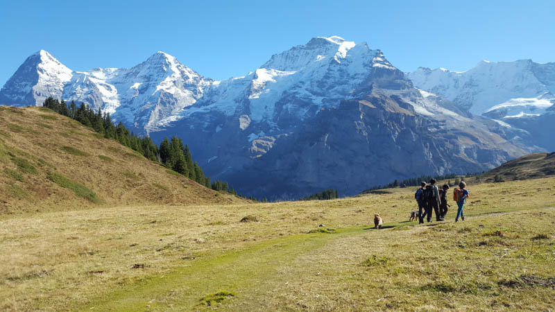


Now we can see Allmendhubel in the distance, almost there.

Dipping down into the forest before hiking back up.

Looking back on the trail.

Some nice waterfalls in early summer.

The last uphill brings you to this trail sign. If you are done hiking, fork left to Allmendhubel for the flower park playground, restaurant and funicular station.

If you want to keep hiking on the Northface trail, follow those signs here. Many options for other trails.

Looking down at the Northface trail.

Allmendhubel Flower Garden
There is a little loop flower trail here with education info about the alpine flowers.

The info signs are in German and English.


Some benches just above the garden.

Some signs have little activities to accompany learning.

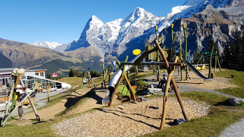
Allmendhubel Flower Park Playground
Just below the flower garden, you’ll find the Flower Park playground, restaurant, and Allmendhubel funicular station.

Optional hike down to Mürren
When you are done at the playground, you can ride down the Allmendhubel funicular to Mürren. Or you can hike down to Mürren.
There are multiple trails leading down to Mürren including a paved road. We usually take the Mürren Blumental trail, which is about 2.2 km, about another 90 mins.

We saw some really nice fall colors when we visited in early October.


38 responses
Hello! Thank you so much for the helpful content you share on here! I am planning a trip to Switzerland next week (it’s been in the works for over a year), and have gotten much helpful information from your posts!
A question for you. What is the main difference between the Murren Mountain View trail and the Northface Trail? Is there a difference in length, difficulty, or views making you recommend one over the
other to a group of four fit women with a baby in a carrier along for the ride? We will only have time for one and I am having trouble deciding between them. Thank you for your help!
So sorry for the late reply! I hope you had a fun time. I prefer the Northface trail to Mürren Mountain View trail. It’s a bit easier (if you hike downhill) and a bit prettier, with the option to visit the waterfall.
Hi your blog is amazing. My husband and I have 3 days staying in lauterbrunnan and we’re having trouble deciding which walks in the region are the best ones to do as there as so many. Which would be your top 3? Thanks
Thanks for the kind words. It really depends on your fitness level and priorities for the hike. If you want hikes in about the 2hr range, I would do this trail, the Mürren Mountain View Trail, the Schynige Platte ridge trail, and Grindelwald First to Bachalpsee. Have fun!
Easier option: From Grütschalp, you can instead follow the easier trail through Winteregg to Mürren. This version of the trail has only 150m elevation gain.
Are the views just as nice as the harder hike?
The views are similar since the trails are parallel.
Hi there. I am interested in doing the hike backwards from Allmendhubel to Grutschalp due to it sounding so much easier. How long would it take since I’ll be going downhill?
Depends on your hiking speed. I’d guess maybe 15 mins faster in this opposite direction.
Hi Tanya!
First of all thanks so much creating this website! It is very helpful for us to plan our trip.
We just have one question – Is it still possible to do this hike if we plan to be in Lauterbrunnen area from 29 Oct to 1 Nov? We have checked that the cable car needed is operating throughout that date, but wondering whether it’s safe to do this hike during that time.
If it’s not, can you recommend us on what to do if we stay in the Lauterbrunnen area around those time? It’s silly but we bought our tickets first without researching about the weather in Switzerland and just found out only after everything is finalized that many trekking tracks and cable cars are closed.
Many thanks!
Hi Diana, so sorry I’m too late on my reply. I hope you found a suitable hike during your trip. I hope you can come back to Switzerland in summer sometime so you can do all the hikes!
Hello again! Another planning question. Weather permitting we’re hoping to cable car all the way up to Schilthorn Viewpoint, then down to Birg to do the Thrill Walk and then down to Murren to play at the playground and hike the Mountain View Trail. For the Mountain View Hike – since we’ll be starting in Murren rather than ending there, how would you suggest ending our day? Do the trail in reverse starting in Murren and then about halfway through turn back so we can get back to the cable car to get the rest of the way down? Or, hike all the way to Gruschalp and cable car down? Our car will be parked at the Stechelberg cable car station.
Thank you!
Hi Brittany
I’d probably just skip the Mürren mountain view trail. It doesn’t make sense if your car is in Stechelberg. Perhaps do a different hike, hiking down from Allmendhubel. Have fun!
Hi Tanya, would you recommend doing this trail in the opposite direction? I plan to start the day with exploring Lauterbrunnen Valley, hiking to Stechelberg (with detours to Stabbauch Falls and Trummelbach Falls) then head to Birg and Schilthorn, before doing this trail in the opposite direction to Grutschalp. Do you think this itinerary is doable in a day? Thank you.
Sure, you can do this backwards. It does sound a bit long though. You’ll need to keep moving and keep an eye on your watch and the closing times. Good luck!
Hi Tanya,
I’ve been following your hiking trips with families for a while now. Just want to say thanks for the great tips, very thorough and well organized.
When you go on hiking trips, have you wild camped in Switzerland? I know regulations are not very clear on the topic, and it’s generally accepted above the tree line, but would like to hear your opinion and experience (if any) on the matter. Not a big fan of the camp sites.
Cheers,
Yes, we have wild camped a few times. You are right, camping above the tree line is generally allowed unless it is a protected area or specifically signed for no camping. However in general they prefer no tents but bivouac, which my husband and son have done. My husband wild camped near the Murgsee a couple times. We wild camped at Tremorgio lake one time. We saw others doing it so we asked at the hut and they said it was ok. If you are camping on someone’s land, you need to ask. I heard that it is quite normal to ask farmers about camping on their land. But you need to leave no trace, including human waste, which is disruptive to the cattle. I read that it was a huge problem last summer with places littered with human waste because of camping. So pack it out or bring a shovel.
Hi,
Your blog is awesome. It is so detail and very informative. I am planning a four day trip to Jungfrau area and I got almost all the details I need to know from your blog.
Thanks a lot for being so considerate and explaining and sharing everything. You are very generous.
I have just one question, I will be driving from Geneva, and which is the best place to stay there??
Lauterbrunnen or Grindelwald??
Thanks a lot.
Have a wonderful day.
Both are nice and convenient places to stay. Grindelwald has more accommodations, restaurants and services, so that might be an easy place to find accommodations. You can’t go wrong with either choice.
This blog is so beautiful to page through. I find it extremely helpful for my upcoming trip in late May/early June. Thank you for maintaining it and hiking these trails to share the information and photos with others so generously 🙂
So glad I could help out. Enjoy your trip!
The trail looks breathtaking! One question though, is it possible to take cable car from Murren up to Allmendhubel, then hike down to Murren? I just want to have a shorter hike, and a less difficult one. And is that trail stroller-friendly?
Yes. You can take the cable car from Stechelberg to Mürren, then the funicular from Mürren to Allmendhubel. Then you can walk back down to Allmenhubel. The easiest way is on the road. Or you can follow the 2km trail to Mürren as shown in this post: https://swissfamilyfun.com/murren-childrens-adventure-trail/ They keep renaming this trail so I don’t know what they are calling it these days. But the trail is there. I just did it last year.
Hi Dear Tanya,
How are you?
Thank you very much for your amazing blog! I’ve been reading it now for about 2 months 🙂
I’m going to Switzerland with my mom in May and really wanted to enjoy the mountain views. We are planning to go by the end of May (around May 20). Do you recommend hiking this trail? Is it Appenzell better you think?
Thank you very much!
Thanks so much! In May, this Mürren trail is likely to not be ready for hiking (probably not until at least mid-June, but depends on the weather). I think Appenzell would be a good choice, particularly Ebenalp, which usually opens already in mid-May. https://swissfamilyfun.com/ebenalp-wildkirchli/ Have fun!
Hi Tanya,
I’m not sure if my previous comment went through, but first of all I’d like to thank you for the amazing swiss content you have in your blog, it has just been helping me so much that you have no idea 🙂
I’d like to know if you think is possible to do this hike or the mannlichen-kleine-scheidegg during May. I’m taking my mom and mom in law and we’d like to see mountain views and to me, as per your pictures, these both are the most amazing ones.
Thank you very much! I’ll keep reading your blog and happy hiking to you 🙂
Hi Heloisa! Sorry for the delay in my response, I got all your messages. As I mentioned in my other response, both the Männlichen and Mürren trails are likely to have snow in late May, but it totally depends on the weather. You might find my spring guide for the Berner Oberland helpful: https://swissfamilyfun.com/spring-berner-oberland-switzerland/
Is camping possible along the trail? Do you need a permit?
I don’t know if camping is specifically allowed along the trail, but wild camping is allowed in some areas if you follow the rules. This document (a PDF) explains those rules: https://www.ticino.ch/dam/jcr:65ec8a47-1717-4db5-ae56-6012f22fc663 I would suspect that this is not a great place for wild camping because it is through alpine areas used for cow grazing. But you could ask at the tourist office and they may be able to put you in contact with the dairy farmers that work that land so you could get permission.
Excellent post though I missed one piece of info: how long does the hike proper (Grütschalp to Allmendhubel) take?
Sorry about that. The trail from Grütschalp to Allmendhubel is about 4.8km and takes about 1h50 to walk.
Hello!
I’ll be doing this hike tomorrow, could you please tell me if this is stroller friendly?
I have an tous terrain stroller and would like to do this trail with my baby.
Thanks in advance to your reply
Sorry for my late reply, I’m just seeing this. As you may have found out, that trail is not suitable for strollers. Hope you found an alternative.
Hi there, the trail looks beautiful. I was just wondering if this trail, and trail similar to this such as northface trail (Allmenhubel – Schiltalp – Murren) is open this april? since i realized most of the trails in switzerland are still closed. thank you!
It just depends on the snow melt. It will likely still have snow in April and might be more of a winter walk. Even if there’s no snow the trail likely won’t be cleaned up for summer season until June, meaning it could have lots of debris. But you could take a look. I’d ask at the Murren tourist office for info when you get there. They usually have good info about which trails are passable.
Hello!
Is that a good hike for if we want to see nice mountainous panoramas?
Absolutely! It has fantastic mountain views almost the whole trail, just a bit in the forest.
This trail looks stunning! 2 silly questions, wondering if you could help:
1. Is it possible to do the trail starting at Allmendhubel and then heading towards Grutschalp? Or do the “Mountain View Trail” signs only point in one direction?
2. Are there any toilets at all along the trail? I’m thinking of bringing my 70 year old mother along, who would be incredibly shy about having to go near the trail. 🙂
Thanks!
Hi Angeline. You can definitely hike the opposite direction, so Allmendhubel to Grutschalp. No problem at all. There are no toilets along the trail, just at the beginning and end. There are forested areas on the second half, nearer Grutschalp, so you could find some privacy if you needed to. I’m not sure how sporty your mother is, some 70yr olds are very active and fit so I make no assumptions. But please remember this is a mountain trail, so a narrow dirt trail, lots of up and down, with lots of rocks and tree roots to walk over. Just so your expectations are correct before setting out. I hope you have a good time.