In late October, larch trees turn bright yellow and orange, making for a spectacular show in the Swiss alps.
In Switzerland, you can usually enjoy these beautiful trees from mid October to early November, when “larch madness” takes over the hiking community.
Below are our favorite places to enjoy the golden larches in Switzerland.
I’ve included a variety of options, including no-hike viewpoints, easy family-friendly hikes, and longer treks away from the crowds. I hope you love it!
What are golden larches
Unlike evergreen conifer trees, the needles on larch trees turn yellow and orange in fall, eventually drop off, then grow back in spring. Larch trees grow at higher elevations, mostly around 1900 – 2100m, just below the tree line.

In Switzerland, you’ll find these trees in southern regions that have rocky terrain, particularly in the Valais and Graubünden cantons.
Our favorite place to enjoy the golden larches is near St Moritz in the Engadin region. Many of my suggested hikes below are from this area.
When to visit for golden larches
The golden larch season varies from year to year based on the weather. In general, larch trees need a few days of frost before they start to turn yellow.
In Switzerland, this typically happens around the third week of October through beginning of November. But this can vary widely depending on the weather.

In 2023, we had warm weather through mid October and the larch trees only just started to turn yellow around the third weekend of October. In 2025 and previous years, we have seen larches in Zermatt as early as the end of September.
When the larches start to turn, the forests will be mostly green and speckled with bright yellow. Over the next couple weeks, progressively more trees will turn yellow, then a deep orange. At the end of the season, the needles will fall off leaving bare trees.
How to know when the larch trees are ready
I monitor the status of the golden larches by looking at recent Instagram posts from the locations I want to hike (each hike below has a link to the relevant tags). I also monitor the hashtag #larchmadness, but these are not limited to Switzerland and aren’t always recent.
Since people often post old pics, I look for less professional looking photos, which tend to be more real time posts by people that aren’t trying to hard to curate their feed.

I also look at webcams, but it can be difficult as many webcams are not pointing directly at the trees. Graubünden Tourism has a “Larch Tracker” linked to seven webcams around the canton, which I find it semi-helpful.
You might find the SwissWebcams.ch website more helpful.
Tips for hiking during golden larch season
The golden larches are typically ready right when many gondolas and mountain resorts are closing for the season. At this time, snow is also common, which can make trails dangerous or impassible.
So you need to choose and plan your hikes carefully, checking the weather forecast, trail status, bus schedules, and other opening times. In my description below, I include alternatives for when buses and cable cars close earlier than larch season.
St Moritz & Engadin
The best region for golden larches is clearly the St Moritz Engadin region. We’ve spent a lot of late October days here so I have a lot of suggestions. I’ve included a few of my very favorites here. See more St Moritz fall hikes.
To check the larch status, you can look at the following instagram tags: #engadin #morteratsch
1. Morteratsch Glacier
This hike is one of the easiest and best for enjoying the golden larches. Since it doesn’t require a gondola, you can visit it anytime without being restricted by opening hours.
The path leads up a valley toward the Morteratsch glacier that shaped this area. The valley is filled with golden larch trees that light up the valley, making for a spectacular scene and postcard worthy pics.

The trail starts at the parking and train station, no gondola required. It’s a wide dirt path, obstacle free, suitable for strollers. My favorite spots for photos are along the river, which flows parallel to the trail.
Along the way, there are signposts with information about the glacier and it’s rapid decline. Children can pick up a free activity booklet to stamp at various posts along the way.
- Location: Morteratsch parking (46°27’12.1″N 9°56’28.8″E) • train station Morteratsch
- Hike: easy • 2 hrs • 6 km out and back • 155 m up and down – see trail map
- Cost: free
- Open: year round
- Status: Camping Morteratsch webcam • Pontresina forecast (near Morteratsch)
➡️ Learn more about the Morteratsch Glacier Trail
2. Lake Staz
Starting at the St Moritz train station, this easy walk circles two lakes surrounded by mountains covered by larch trees. You can do a long loop around both lakes or just go there and back if you are short on energy and/or time.

The wide dirt path is obstacle free, suitable for strollers and wheelchairs. Possible year round.
- Location: Parking at Via Dimlej, St Moritz (46°29’51.1″N 9°50’53.5″E) • train station: St Moritz
- Hike stats: easy • 7.5 km loop • 90 m up/down
- Cost: free
- Open: year round
- Status: webcam • weather
➡️ See details for Lake Staz walk
3. Val Trupchen
This trail in the Swiss National Park leads up a long valley filled with larches. You experience the trees close up as you wander through the forest, as well as many views of the surrounding mountain peaks and hillsides covered with the colorful trees.

The hike ends at a wide open alpine meadow at the end of the valley. Then you hike back along the river, optionally stopping at a mountain hut for refreshments.
This hike is popular for wildlife observation. At one of the designated rest areas, several groups were scanning the mountain with binoculars and excitedly informing others when they spotted animals.
I loved this hike so much, just delighted every minute and taking so many pictures. It was gorgeous in the sunshine but would be nice even on a cloudy day.
- Location: Parking: 46°37’04.7″N 10°00’36.3″E • bus stop S chanf, Parc Naziunal
- Hike: moderate • 4 hrs • 14.2 km loop • 470m up and down – see trail map
- Cost: free
- Open: bus and restaurants open through third weekend of October
- Status: trail status • nearby webcam • weather
➡️ See trail map and details for Val Trupchen hike.
4. Lake Saoseo & Lake Viola
This trail visits two gorgeous alpine lakes in Val da Camp south of St Moritz. The entire valley is covered with golden larch trees, but they are particularly beautiful reflected in the clear water of the lakes.

If you want a short hike, you can ride a shuttle bus up the valley. Then only a 20 min to the first lake and a 5 km loop to visit both.
The shuttle only runs once in the morning and only fits 20 people. You must call ahead to reserve a spot. It only runs through the third weekend of October.
Without the shuttle, you’ll need to do the longer hike that starts at the parking and regular bus stop.
- Location: Parking at Sfazù – 46°23’25.6″N 10°04’43.1″E • bus stop Sfazù, Fermata
- Trail: Short hike with shuttle 5.3 km loop • Long hike without shuttle 15.2 km loop
- Cost: free without shuttle
- Open: shuttle runs through third weekend of October
- Status: webcams • weather
➡️ See details for Val da Camp lake hike
5. Lake Cavloc
From the Majola pass, this hike takes you to the large Lake Cavloc shown below, surrounded by tall mountain peaks on all sides.

You can simply hike there and back or do a loop into the forest, leading to a second small lake with beautiful reflections of the golden larch trees.
- Location: Parking Maloja Val Orden (46°23’38.0″N 9°41’35.3″E) • bus stop Maloja, Cad’Maté
- Hike: moderate • 2 hrs • 7 km loop • 190 m up, 200 m down • see trail map
- Cost: free
- Open: no gondola, so always accessible / also a winter hiking trail
- Status: Maloja webcam • weather
➡️ See details for Lake Cavloc trail
6. Lai da Palpuogna
If you are driving to St Moritz, you should definitely stop at the beautiful Palpuogna lake on the way. It’s only a couple minutes walk from the side of the road, so easy to access.

It’s not well marked and only a few parking spots on the side of the road. So watch the map carefully after you pass Preda, so you know when to slow down and look for an open spot.
You don’t have to walk far to get stunning views of the yellow trees reflected in the water. I slightly prefer the side of the lake opposite of the road, but it depends on what time of day you are there.
In October, I find the light on the trees is better in the morning as the evening shadows are very long.
The walk around the lake only takes 20-30 minutes, so plan more for a leisurely picnic than a demanding hike. There are several grill pits around the lake, some with firewood, some with benches and tables.
- Location: near Preda – 46°35’00.9″N 9°46’53.8″E
- Cost: free
- Open: road usually open through November / the Albulapass road is usually closed mid Dec to mid May, depending on snow conditions
- Status: nearby webcams • weather • Albulapass road closures
➡️ Learn more about Lai da Palpuogna
7. Alp Grum & Lake Palü
The Alp Grüm viewpoint overlooks the pretty Lake Palü in southwest Switzerland. The area is packed with larch trees, making for a golden paradise in late October.

If you’re riding the famous Bernina Express train, you’ll make a 15 min stop here for pictures before continuing to Italy.
Otherwise, you can ride to this viewpoint via a regional train that does not require a reservation or advance booking. At a minimum, we suggest a short walk down to the idyllic Lake Palü, about 20 mins.
If you are driving, you’ll need to park at the Bernina Pass and hike there (90 mins) or ride the train there (10 mins).
- Location: Alp Grum near Preda – 46°35’00.9″N 9°46’53.8″E
- Cost: free or train fare
- Open: train runs year round • hiking trails usually open thru early November unless it snows
- Status: www.alpgruem • webcam
➡️ Trail map and instructions in my Alp Grum post
Valais Region
The Valais is a large region with many larch forests. The most famous is Zermatt and the larches often turn yellow here earlier than other places.
SponsoredDiscover top exclusive offers today!
Click here to learn more and take advantage of these limited-time deals.
We recently stayed in Sion, which was a great base to visit many lesser known mountain areas full of larches.
8. Lac Bleu Arolla
This tiny lake is one of the most photographed golden larch spots in Switzerland. The contrast of the bright yellow and orange with the bright blue water is absolutely magical.

The hike is short and not difficult, just 40 mins uphill from the parking and bus stop. You can do longer tours to enjoy the larch forests more before ending at the lake. I have two suggestions in my Lac Bleu article.
The downside is that this hike is located near the end of the Arolla valley, about an hour drive from Sion and very far away from most cities in Switzerland (4h by public transport from Zurich!) So better to stay overnight in the region if you can.
Trail: 1.5 h • 2.7 km round trip • 263m up & down
➡️ See trail info for Lac Bleu Arolla
9. Nendaz Bavalaux Forest
You’ll find the oldest larch trees in Switzerland at Nendaz, a mountain resort in central Valais near Sion. As soon as you step off the cable car, you already see beautiful larch trees next to the Tracouet lake, a taste of what’s to come.

The trail starts by hiking up to the Dent de Nendaz peak, a viewpoint at 2463 with a panorama view across the Valais valley. Next traverse a rocky ridge, where you can admire larch forests on both sides of the mountain
Then the best part, descending through a thick larch forest, also filled with red blueberry bushes. The trail connects to a service road and loops back to your starting point, passing the giant ancient larch trees.

The cable car typically runs until the last weekend of October (check status). If it’s not running, you could hike up to the start, about 2.5 hours, then do the hike (not my first choice).
Trail: 2.5 hours • 6.3 km loop • 517 m up, 523m down
➡️ See trail map for Nendaz Balavaux Larch Loop
10. Aletsch Arena
The Aletsch Arena has a huge larch forest on the mountain facing the glacier. One of the nicest ways to enjoy these trees is on the Aletsch Suspension Bridge trail.

You start by riding a cable car up to the alpine village Belalp. Then hike down to the gorge cut by the glacier where you can cross the suspension bridge, 124m long and 80m high.
Then hike up the mountain through a dense larch forest with occasional views of the glacier. The trail leads over the ridge and down another alpine village Riederalp, where you can ride a cable car down to the valley and catch a train back to your starting point.
- Trail: moderate • 4.5 h • 11 k • 560m up, 750m down
- Location: start at Blatten bei Natters / end at Riederalp cable car
- Open: Blatten-Belalp cable car open thru last weekend of October/ Riederalp cable car open year round
- Status: Belalp webcam • Aletsch Arena webcams • Riederalp weather
- Instagram: @aletscharena #aletsch #riederalp
➡️ Learn more about Aletsch Glacier Suspension Bridge Trail
If the Belalp cable car is closed when you go, you can start in Riederalp and hike up to the ridge for views of the larch forest and glacier. You could hike down to the suspension bridge and back up, but it’s probably not worth the effort. Probably better to just enjoy the views from the ridge.
11. Zermatt Glacier Garden
This valley above Zermatt has been carved out by the Gorner glacier over hundreds of years. Today is it filled with larch trees on both sides of a river that flows from the glacier.

Below the valley, there’s a nice playground and picnic area in the forest and a slightly scary suspension bridge to cross.
The mountain transport that services both trails is open year round. But you can only do these trails if there is no snow. Definitely don’t try option 2 if there is any snow or ice on the trail, which would make the steep sections quite dangerous.
Option 1: Ride the Matterhorn Glacier Paradise gondola to the Füri station. Then hike up to the glacier valley about 90 mins. On the way back, visit the Gletschergarten where you can see geological formations created by the glacier. Pass through the picnic area, cross the suspension bridge and end back at Füri.
- Location: Zermatt – Füri cable car (see on map)
- Trail: moderate • 3 hours • 6.4 km round trip • 300m up & down • trail map • trail status for bridge
- Open: Zermatt-Furi cable car runs year round, so no restrictions
- Cost: round trip on Zermatt-Furi cable car
Option 2: If there is no snow, you could alternatively hike down to the Glacier Garden from Riffelberg, accessible via the Gornergrat mountain railway. Learn more.
Zermatt info: webcams • weather • Zermatt trail status
12. Derborence Valley
The hidden valley is a gem anytime of year. But in October, it’s full of yellow, both golden larches and wispy birch trees.

You can drive right to Lac de Derborence and enjoy the fall colors from the lake without hiking. But we suggest exploring the whole valley on a loop tour, which lets you enjoy different perspectives of this beautiful place.
⚠️ The bus only runs here until mid September, so you haven’t arrive by car. It’s a scary drive on a one-lane winding mountain road with minimal turnouts, plus a long stretch in a one-lane tunnel. Good luck!
Trail: 3.5 hours • 10.4 km loop • 602m up & down
➡️ See trail map for Derborence valley tour
⚠️CLOSED – Lötschental Valley
⚠️In summer 2025, a devasting landslide destroyed the village Blatten in the Lötschental. Due to this, most trails in this valley are closed, including this trail leading to Fafleralp. They expect the restoration project to take up to 3 years. Unclear when the trails will be open again.
This popular hike traverses a mountainside in the beautiful Lötschental valley, which is filled with larch trees.
The panorama trail starts at the top of the Lauchernalp cable car and ends ends at Fafleralp, where you can catch a bus back to your starting place. This version of the trail is 11.5km one way, see trail map.

If you have a car, you can instead drive to Fafleralp where there is a big parking lot. Then you can do a short hike to one of the lakes, like Grundsee or Schwarzsee, which have lots of larch trees and are beautiful photo spots.
- Location: Lauchernalp cable car or Fafleralp parking
- Cost: one way cable car + bus fare to return to start
- Open: cable car open year round / bus until third week of October
- Status: Lötschental webcams • Lötschental weather
- Instagram: @loetschental #lötschental
Learn more about the Lötschental Panorama Trail.
Bernese Oberland
13. Oeschinensee
Only a few places near Interlaken have larch trees and Oeschinensee is probably the best. The west side of the mountain along the lake is covered with them, lighting up so prettily with the fading autumn sunlight.
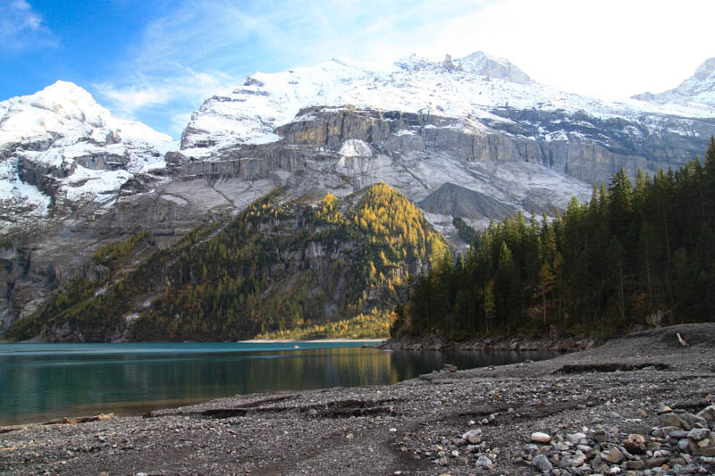
When the gondola is open, it’s an easy, short walk from the gondola station to the lakeside, about 40 mins. At the lake, you’ll find restaurants and a picnic area. In dry weather, you could also do the panorama trail above the lake, but be wary of ice.
- Gondola to lake: easy • 2k to lake • 1h30 round trip • 110m up & down – see trail map
- Cost: return trip on gondola • discount with Swiss travel cards
- Open: Gondola open thru 9 Nov 2025.
- Status: live status • webcam • weather • www.oeschinensee.ch
- Instagram: @oeschinensee #oeschinensee
Learn more about Oeschinensee
Zurich Day Trips
While most larches are in the far south of Switzerland, there are some larch forests in mountain areas southeast of Zurich: Davos Klosters, Lenzerheide, and Flims Laax regions.
These are more reasonable day trips from Zurich, about 1.5-2.5h each way by car or train.
14. Vilan Peak
This hike was my favorite discovery of 2024, doing it twice in fall that year. I missed the peak larch colors – 30 Sept was too early and 9 Nov was much too late. I’m determined to catch it right this year.

The loop trail starts with a steep climb up to the Vilan peak, overlooking the Rhine river valley.
Then you descend and loop back through alp meadows and forests. This section has a lot of larch trees, but you’ll have to time it right to get the peak color. I’d guess around third weekned of October.
Trail: 4 hours • 10.5 km loop • 885m up, 717m down
➡️ See trail details for Vilan Peak Hike
15. Davos Klosters
This region borders the Engadin, so it makes sense that the closer you get, the more golden larches you’ll see.
Here are a few trails we suggest for seeing larches in this region.
Sertig Dörfli: 2h45 10.4km one way • 369m up, 166m down
Seehorn peak hike: 7.4 km loop • 681m up & down (suggested by
Alter Zügenweg (789): 3.5 hours • 12km one way • 400m upm 660m down
➡️ See more fall hikes in Switzerland






3 responses
Hello, thank you so much for this super helpful post!
We’re going to the St Moritz / Engadin region in October and have the opportunity to either go 11-15 October or 17-21 October.
I know the timing of the larch coloring varies year to year, but what would you say is the best weekend for both weather and larches? I guess weather wise the earlier weekend may be a bit better (as november is often gloomy), but for larches better the third weekend (although I understand it’s already freezing in the region some nights, which may accelerate the coloring?)
The foliage tracker says colors are at their peak late October, but as I’m traveling with my elderly mom we can’t hike much so are dependent on cable cars (which stop after 20 Oct).
Merci!!
I think the larch trees will be a bit early this year because of the early snow and frost in mid September. So I think the weekend of Oct 19-20 should be ok. Good luck!
I love this country, my dream is to go there on a trip! My daughter even bought me socks with a mountain motif socks and gifts