We’ve wanted to do this hike since we first visited Riederalp back in 2010 and I’m happy to report it exceeded my expectations. Back then our kids were small and we could only manage the short ridge trail at the top, which is wonderful and you should do that too. But I wanted to get closer to the glacier and cross the suspension bridge, both of which we finally did on this fantastic hike.
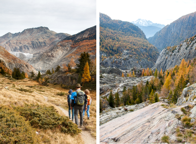
We were also lucky to go in October, when the famous Larch trees were bright yellow, which I’ve always wanted to see. It was a special hike at a special time of year.
Contents
| Location: | Valais, Switzerland |
| Address: | Trail start at Belalp cable car: Rischinustrasse 5, 3914 Blatten bei Naters Trail end at Mörel: Furkastrasse 28, 3983 Mörel |
| Car: | Brig Bahnhof parking: Bahnhofstrasse 1, 3900 Brig-Glis From Bern or Interlaken 2hrs / from Zürich 3hrs |
| Train: | Bus stop: Blatten b. Naters, Luftseilbahn From Bern 1h35 / Zermatt or Interlaken 2h10 / Zürich 2hr40 |
| Trail: | 11 km, starting elevation 2100m |
| Condition: | alpine path, no strollers |
| Skill: | moderate, 700m descent, 600m ascent |
| Services: | restaurants at beginning and end, picnic area in middle |
| Cost: | Adult round trip hiking ticket CHF 28.20 (includes cable cars, bus, train) SBB Half-fare and Junior cards accepted. |
| Open: | late June through October |
| More info: | www.aletscharena.ch • webcams |
Gallery


Overview
This trail is in the Valais region of in southern Switzerland, near Brig. See on Google Maps.

Trail overview
This is a one way hike, starting in Belalp (2) and ending Riederalp (4).

We took a bus from Brig (6) to Blatten bei Naters (1). Then a cable car to Belalp (2) at 2100m where the trail starts. The trail descends to the glacier gorge where you cross the suspension bridge (3). Then up the mountain and over the ridge and down to the Riederalp village (4). Ride the cable car down to Mörel (5), where you can get a train back to Brig.
Download summer hiking map for the Aletsch Arena.
Hiking map
The trail is about 11 km, first descending 700m of elevation to a suspension bridge over a gorge cut by the glacier. Then you hike back up the other side through a forest, with 600m of elevation gain. The hike ends in Riederalp, where you can take a cable car down to the valley and catch a train back to your starting point.
See trail map on Komoot • SchweizMobil • OutdoorActive
Trail Conditions
The trail is a narrow, rocky dirt alpine trail with lots of switchbacks. It’s not dangerous and does not require any technical equipment, but sturdy hiking shoes with ankle support and hiking sticks would be helpful. I’d recommend this for children over 8 with hiking experience.
Services
There are mountain restaurants at both ends of the hike, but nothing in between. There are two official picnic areas with tables and fire pits in the middle of the hike, one right next to the suspension bridge.
Getting There
This is a one way hike starting at the top of Blatten bei Naters – Belalp cable car and ending at the top of the Riederalp-Mörel cable car. You can easily use public transportation to connect these areas.
By public transportation:
Take a train to Brig, then catch a bus to Blatten bei Natters, L. The bus drops off at the Belap cable car. At the end of the hike, take the Riederalp-Morel cable car down, then catch a train back to your home base.
By car:
If you are driving, I would probably park at the Riederalp cable car station in Mörel, where you end the hike (Furkastrasse 29, 3983 Mörel-Filet). More parking available at the nearby Mörel train station. Then use public transportation to reach the start of the hike. From Mörel, take the train to Brig, then a bus to Blatten b. Naters, Luftseilbahn, about a 48 min journey.
Alternatively, you could park at the Brig train station: Bahnhofstrasse 1, 3900 Brig-Glis. In this case, you would take a bus from Brig to Blatten b. Naters, Luftseilbahn (about 22 mins). At the end of the hike, you would take a train from Mörel to Brig (about 9 mins, connections about every 30 mins).
Ticket Prices
You will ride the Belalp cable car up at the beginning and the Riederalp cable car down at the end.
Blatten –> Belalp cable car: Runs every 30 minutes, early June through late October. Adult full fare one way CHF 14. SBB Half-fare and Junior card accepted. See website for current details.
Riederalp Mitte –> Mörel: Open year round. Runs every 35 minutes. See website for current timetable. Adult full fare one way CHF 9.80, SBB Half-fare and Junior card accepted. Free with GA or SBB Tageskarte.
Last time we went, you could buy a round trip ticket for this hike, called “Kombifahrkarten Hängebrücke”. You can buy a version that just includes the cable cars on both sides of the hike – CHF 19/adult. Or you can buy a version that includes mountain lifts and bus/train between the two ends of the hike – CHF 28.20/adult. Discount with GA, SBB Half Fare and Swiss Travel Pass. See website for details.
Planning your day
Here’s our schedule for doing this as a day trip from Zurich. It was a long day, but worth it. I estimated 5 hours hiking time, but it actually took 6 hours, which included a picnic break and rest breaks for our son that got sick on the second half of the trail. We arrived in Riederalp at 17:45, with just enough time to catch the 18:03 cable car down. In retrospect, I would caught a train one hour earlier from Zurich so we didn’t feel rushed and finish so late.
08:02 Zurich HB train –> 10:11 Brig
10:18 Brig, Bus 624 –> 10:40 Blatten b. Naters
10:50 depart Blatten-Belalp cable car
11:12 arrive Belalp
Hike 11 km, about 6 hours, finish 16:30?
17:03 depart Riederalp Mitte –> 17:15 Mörel
17:22 depart Mörel –> 17:33 Brig
17:20 depart Brig –> 19:58 Zurich HB
I hope all this info helps! Leave a comment and let me know how your day on this trail goes.
Photo story of the trail
Now let’s look at some pretty pictures before we get to the logistics. At the bottom of this post, I have more info about how to get there and scheduling your day.
Here’s the top of the Belalp cable car.

First a 2 km walk on a dirt road through the alpine village.
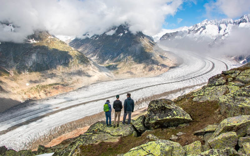
After 2 km, you reach this view over the glacier. If you are here with little kids or a stroller, enjoy the view and turn back. The alpine trail starts down from here.

Some crazy switchbacks.

I appreciated the safety cable.

Yellow trees everywhere!!!
This would have been a good place for our picnic.
At this point, there is a detour to the Aussichtpunkt Gletschertor, aka Viewpoint Glacier Gate. I assume this gives a closer view of the glacier, which you will not get otherwise. I mistakenly thought the suspension bridge would go over the glacier (it does not!), so we opted to skip the detour. Plus the hike was taking us longer than we expected and we were worried about finishing before dark. So we hurried past. But I regret it and recommend taking this detour if possible.
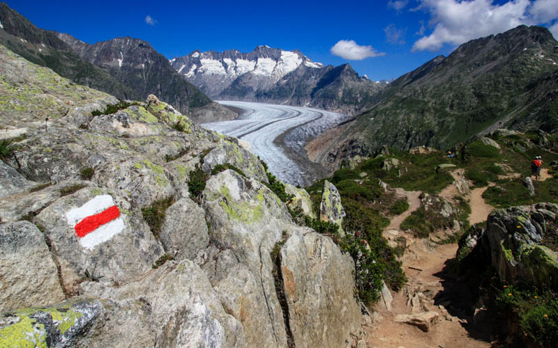
To continue the main train, follow the signs and trail markers to Hängebrücke, the bridge, across this rocky landscape.


We had our picnic at the tables near the bridge. It was convenient, but honestly, there were prettier areas to stop for a picnic.

Crossing the bridge.
See that the bridge crosses over the river and you can only barely see the glacier from here.

Climbing back up the other side, only 5 more km and 600m up to go.
Some of these areas are protected nature areas as noted by the sign and you are asked to stay on the official paths. There were also signs forbidding fires, so bring a cold lunch.

This little pond was marked as a protected area and you were not allowed to walk around it.

Now some views of the glacier.

Heading up through the dense forest.

Evening light on the trees and mountains.

Almost to the top.

Now a 1.5 km descent down to the Riederalp cable car to finish the hike.

You can optionally walk on the road.


2 responses
Hi Tania,
I think the car park GPS coordinates and link to Google Maps are incorrect.
Best regards,
Denis
Thanks Denis! I’ve updated the post to link to the Brig train station parking.