
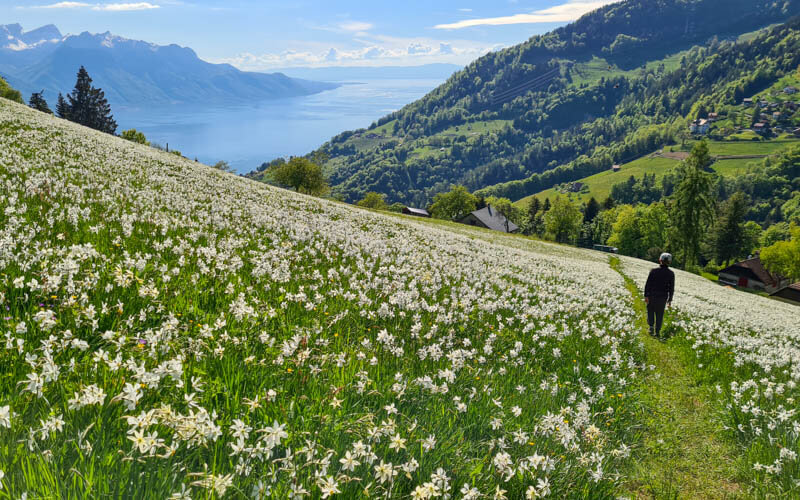
Of the six narcissus trail near Montreux, we think the Haut de Caux trail is the prettiest place to enjoy the narcissus flowers. The biggest flower field on the trail has a panorama view of Lac Leman and the surrounding mountains, making for great pictures and lasting memories. We suggest starting your day by visiting the Rochers de Naye mountain viewpoint above, then getting off the mountain train halfway down to start your hike. It’s a full day of beauty in this special part of Switzerland.
Contents
Note: If you have young children, I would instead recommend the Les Pléiades narcissus trail, which has shorter and easier options for families.
Our visit was in collaboration with Montreux Riviera tourism, who sponsored our trip.
| Location: | Lake Geneva Region, western Switzerland |
| Trail Start: | Haut-de-caux train station |
| Trail End: | Glion train station |
| By car: | Parking at Montreux train station (Avenue des Alpes 72, 1820 Montreux) 1hr mins from Geneva, 1hr10 from Bern, 2hr30 from Zürich |
| By public transport: | Montreux train station 1hr from Geneva, 1hr35 from Bern, 2hr40 from Zürich |
| Trail: | 6.5 km, about 2hr30 |
| Elevation: | highest point 860m, 160m up, 630m down |
| Condition: | paved road and dirt footpath, no strollers |
| Skill: | moderate |
| Open: | best late May for the narcissus flowers trail usually open May – Oct |
| More info: | montreuxriviera.com • nearby webcam |
Overview of trail
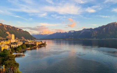
This trail is located in the mountains above Montreux in western Switzerland. It’s best to access the trail with Rocher de Naye mountain train but you can also drive there (details below).
The Montreux area is famous for narcissus flowers, which bloom late May to early June. There are six suggested trails for enjoying the flowers as shown on the map below: 1. Les Avants, 2. Les Plèiades, 3. Oregvaux, 4. Le Mont-Pèlerin and here at 5. Glion and 6. Haut de Caux. The flowers bloom at different times on the various trails based on elevation and sun exposure.
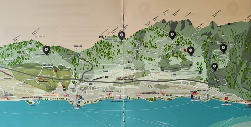
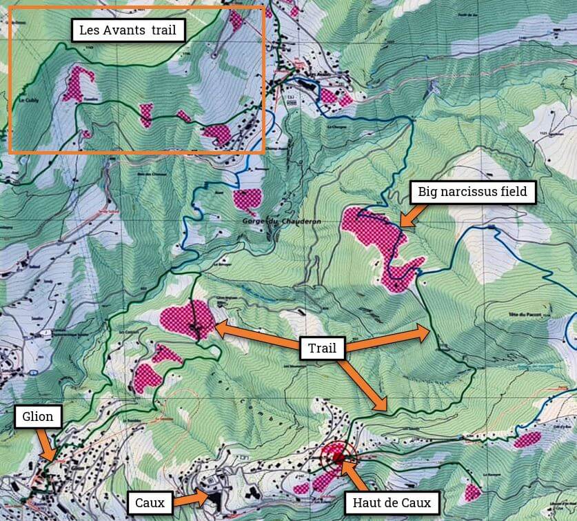
Our hike was in the Haut de Caux/Glion area, in the mountains directly above Montreux. The map below shows where the narcissus patches are in this area.
Trail map
I wanted to see as many narcissus as possible, so I combined the suggested Haut de Caux trail and Glion trail into one hike as shown on the trail map below. It’s a one-way path from the Haut-de-Caux train stop to the Glion train stop.
View trail map on Komoot • SchweizMobil • AllTrails • OutdoorActive
Trail description: We started at the Haut de Caux train stop, followed the paved road (basically no traffic) to the narcissus fields (labeled #4 on the trail signs at Caux). Then we split onto a narrow dirt footpath through the fields. Then we descended on a steep forest trail to the Gorge du Chauderon. I had hoped to hike down the gorge all the way to Montreux but it was closed temporarily due to an accident. So instead, we looped back to Glion where we caught the mountain train down to Montreux.
Important Note! This path is not well marked with trail signs or markers. So I highly recommend downloading the GPX onto a mapping app on your phone (I suggest Komoot or SchweizMobil). I checked this frequently to make sure we were on the right path.
Easier version: For a slightly easier version, you could simply walk down the road to the narcissus fields, wander down the fields as far as you like, then hike back up to the road and walk back to Haut de Caux. In this version, kids could bring their kick scooters for the paved road section, making that part much quicker. I would also suggest the Les Pléiades narcissus trail, which is better for families with small children.
Getting there
This trail is best accessed by the Rocher de Naye mountain train which starts at the Montreux train station. This map will help you understand the locations I reference in the directions.
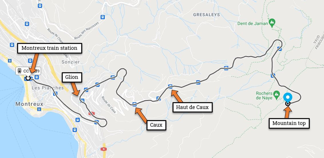
By train: Get yourself to the Montreux train station. Switch to track 8 where you can board the Rochers de Naye mountain train.
By car & cogwheel train: Drive to Montreux and park in a parking garage near the Montreux train station. The closest is Parking de la Gare (near Avenue des Alpes 72, 1820 Montreux). If that’s full, try Cite Center at Grand’ Rue 86, 1820 Montreux. Walk to the Montreux train station, buy your tickets and go to track 8 to board the Rochers de Naye mountain train.
By car directly to trail: It is possible to drive up the mountain and park where the trail starts in Haut de Caux or ends in Glion. Then you would need to take the train to get back to your car. I suggest parking in Glion, taking the train to Haut de Caux, then hiking to your car at Glion. That way you could time your arrival with the train schedule.
The Glion parking is at the train station – Route des Chemins de Fer 5, 1823 Glion. You can also park at the start of the trail at Haut de Caux – Route des Monts 31, 1824 Caux (GPS: 46°26’03.1″N 6°56’46.4″E). The parking next to the Le Coucou Hotel-Restaurant (delicious food there by the way), but don’t park in spots reserved for hotel guests.
Tickets & operating times for mountain train
The mountain train runs hourly from Montreux train station, starting at 8:17. The last train down from the top at Rochers de Naye is 18:11. But last train from Glion is later at 22:58. So you can do an evening hike and still catch the train to Montreux.
You can buy tickets for this train online on the MOB website or at the Golden Pass Center in the Montreux train station.
Your ticket price depends on where you plan to hike and if you want to also ride to the mountain top. If you ride to the top of Rochers de Naye and hike on your way back down, a round trip ticket costs CHF 70/adult, discounts for SBB GA & Half-fare and children 6-16. Kids with a SBB Junior Card or under 6 ride free. If you have a Montreux Riviera card, the trip costs CHF 26.50.
If you are only riding up for the hike, it’s much cheaper. For example, a one-way ticket from Montreux to Haut de Caux is CHF 9.20 (normal SBB discounts apply) and is free with the Montreux Riviera card. I won’t give all ticket variations here. Just tell the ticket office what you want to and what discount cards you have and they will sell you the right ticket.
Check MOB website for current prices and operating times.
On the trail
Riding up the mountain train
Here is the vintage cogwheel train that services the Rochers de Naye mountain area.

The right side of the train gets slighter better views down to the lake during the journey to Haut de Caux.

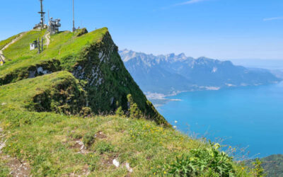
Detour to Rochers de Naye
Before hiking, we took the train to the top at Rochers de Naye, which I highly recommend. You get a great panorama view of the region. There are two restaurants, marmot enclosures, alpine flower garden and short wander along the cliffs. See my Rochers de Naye post for details.

After exploring the top, we rode the mountain train back down and got off at the Haut de Caux stop.
Starting the trail at Haut de Caux
By car or train, let’s assume you got yourself to Haut de Caux. Near the parking, there is a small playground where there is a fountain to fill up your water bottles and a public WC.

When I got to Haut de Caux, I was totally confused and didn’t know where to see the narcissus. There are a few narcissus fields right in Haut de Caux, but in private gardens behind fences, like the one below. I got worried and wasted time wandering around the little village trying to figure out where to see the flowers. Don’t worry! Just get on the trail. The flowers are much much much better later on.

You’ll see this map near the parking. The red patches are narcissus fields. We chose #5 because it’s the largest.

The sign also has trail descriptions as shown here. The description for trail #5 only accounts for the walk along the road to the #5 patch, not walking down through the flowers as we did.

Starting the trail along the road
Ready? Start walking on the paved road that leads east away from Haut de Caux. It’s a quiet road, only one car passed us. This part is not amazing, but it is cool in the shade. Just enjoy the conversation with your hiking partners.

After about 15-20 mins on the road, you’ll see a dirt road/path forking to your left. It doesn’t have a big trail sign or marker just a little wood arrow. This is your path.

We totally missed the path the first time and kept walking until we exited the forest and got this nice view of the lake and narcissus patch. If you see this, you went too far just like us. Don’t stress, enjoy the view then turn around and go back to that dirt road.

Glad we missed our turn so we could get this view.

Hiking down through narcissus fields
When you turn on the dirt “road”, you start to see lots of narcissus on both sides, but behind fences.

We were super excited to see this big patch and took lots of pictures. But it was hard to photograph from behind the fence. Don’t worry. It gets so much better.


Cuckoo for narcissus!

Loved the mountain background for these pics.

The cows had better access to these flowers than we did at this point.

The footpath continues down a grassy field, most of the flowers on the left side of this “fence”.

Now it gets exciting. The narcissus fields just get bigger and more full the longer you walk.

We passed a couple mountain homes. I was tempted to #swingtheworld here, but I decided to respect their private property.

I wanted to move into this house.

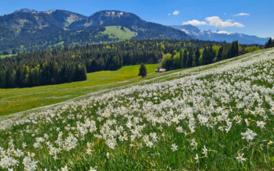
Then we turned the corner and hit the jackpot!

At the edge of the forest, the path splits. With no sign, I wasn’t sure if we were allowed to walk down the hill with all the flowers. But yes, it is a public walking path. A sign here reminds you to stay on the path and not enter the narcissus fields. So walk down on the path and sing as you go.

All my spring flower dreams coming true right here.
Take your time and a million pics.

Looking back up the path. We sat down in the path and just enjoyed the breeze through the flowers for awhile. I suggest you do the same.

Looping back to Glion
Eventually we had to leave the narcissus fields, so sad. The path continues downhill past these houses.

Then you briefly join the road, turning to your left. After a few minutes, roads and paths start forking off in various directions, but not so many signs. So now is a good time to check the map on your phone. You have various options to get back to the mountain train at Caux or Glion.

We hiked down a narrow foot path through the forest to join a trail leading back to Glion.

It was very steep and slippery at times. I wished I had my hiking sticks.

Eventually we joined a road and found a trail sign pointing to Glion.

The trail forks onto a footpath leading to Gorges du Chauderon. We wanted to hike all the way through the gorge, but it was closed temporarily because of an accident. So we just walked toward the gorge on this path, then took a fork leading to Glion.

Very nice section near the river that leads to the gorge.

Since the gorge was closed, we followed signs to Glion as shown on the first real trail sign of the hike. This is part of the official Glion narcissus trail.

The narcissus were no longer blooming on this part of the trail at lower elevations. So I didn’t take any pictures here.
Arriving at the Glion mountain train station. The train runs hourly (usually on the xx:53 or xx:58). Last train down at 20:58. Check current schedule on MOB.ch.

If you miss the train, you can take the funicular instead which runs more frequently. The funicular goes down to the lake at the Territet train station, where can ride train one stop to Montreux or a bus.
Video of the trail
Here’s a video of our Haut de Caux hike in late May.
That’s all for now. I hope you love this trail as much as we did. After you do this trail, come back and leave a comment letting us know what you thought.
See more fun things to do in the Montreux Riviera
See more wildflower hikes in Switzerland


6 Responses
Hello! What an amazing site you have!
I enjoyed watching your videos and can’t wait to do every single hike and share!
Which hike do you recommend to do around the 20th of April to see the narcissus or daffodils blossoms?
Thank you in advance for your advice
Best
Hi Luchi, Glad you are finding our site helpful. Unfortunately, the narcissus flowers usually don’t start blooming until the end of May. My post has a link to the website that monitors the blooms. In April, better to visit the cherry blossoms or crocus flowers. See this post for ideas: https://swissfamilyfun.com/spring-flower-hikes-switzerland/
Thank you so much for this post – what a hidden gem! I would definitely recommend hiking sticks in the forest trail leading to Glion. It was covered in thick wet leaves and very slippery; I fell once even with sticks. Also, at the 2.11 km mark on the Komoot map, before the big narcissus field, you hit a fork where you can either go left, downhill, or right and continue along the path (following a sign that says “Les Avants”). The app said to go left, but I followed the worn trail and it just circled around the house the other way and rejoined the app directions. Some people had already trampled the grass by going left. Otherwise I followed your instructions to the letter – thank you!
Glad you enjoyed it! Thanks for the feedback on the route. I’ll try to adjust the map accordingly.
Hello,
A quick question that, which part of the trail that your picture of the Narcissus and the lake was take? The picture right below “ All my spring flower dreams coming true right here.”
I am taking my parents (who are both around 70) – was really amazed by the pictures in this post but the entire trail is still a bit too long for then. Wondering that if we only take trail #5, walk into the narcissus field a bit and then com back to Caux, as opposed to hiking to Glion
Yes, that trail is a bit long. You could walk from Haut de Caux out to the viewpoint you describe, then walk back the way you came. But it’s still might be a bit long for them. If you look at the hiking map in my post, that picture was taken at about the 2.34 km mark. If you click on the title of the map, it opens in the Komoot app and you can drag the pointer along the elevation profile to the 2.34 km mark and see what I mean. Good luck!