If you want a hike with cherry blossoms, we suggest this lovely trail near Zug, with dozens of cherry trees that typically bloom in mid to late April. Our family did an 8 km path along the east side Zugersee lake, with sweeping views across the lake to Mt Rigi. Athough it’s not “all cherry trees, all the time” like the über popular Frick cherry blossom trail, it’s much quieter with more charms than just the blossoms. This is definitely becoming an April tradition for us.
We did this trail on 17 April 2021, which was a little early for full bloom this year. To see if the cherry blossoms are in bloom, you can email or call the Zug flower hotline: 041 723 68 00 or tourism@zug.ch
| Location: | Zug, Central Switzerland |
| Address: | Start: Zug Fridbach train station End: Walchwil Bahnhof |
| By car: | metered parking at train station Bahnhofstrasse 5, 6318 Walchwil 35 mins from Luzern, 40 mins from Zürich |
| By public transport: | 45-50 mins from Zürich or Luzern to Walchwil Bahnhof |
| Trail: | 8 km one-way, about 2.5 hours |
| Elevation: | highest point 550 m, ascent 240m, descent 225m |
| Condition: | paved and dirt path |
| Skill: | moderate |
| Open: | year round, weather permitting cherry blossoms around mid-April |
| Cost: | free except train fare between start/end |
| More info: | Zug Tourism • webcam |
Location
This cherry blossom trail is located near Zug in central Switzerland.
Hiking map
Zug Tourism has a page describing three cherry blossom trails. The full trail suggested by Zug tourism is 18 km, along the east side of the Zugersee lake, stretching from Zug to Arth. There was no way our family was doing the full trail. So instead, I mapped out a much more reasonable 8 km section (see the map below) that catches the highlights. This shorter version starts 2 km south of Zug and ends at Walchwil. It’s still a long hike for kids, with quite a bit of elevation gain. So best for 7+ that can go the distance.
See map on Komoot | Schweiz Mobil |
Shorter options. Zug Tourism suggests a smaller 6.3 km loop starting in Zug, but most of that is in the city. Swiss Travel Girl suggests this 5km downhill walk from Zugerberg to Allenwinden, better later in April because it’s higher elevation.
Getting there
Since this is a one-way trail, you’ll need public transport to connect between two ends. We suggest hiking southwards, so plan accordingly.
By car: We parked at the Walchwil train station and rode the train to the start of the trail at Zug Fridbach train station. The train between these two stations runs about every 30 mins. Check the current schedule on SBB.ch. At Walchwil, there are a few metered spots outside of the train station, CHF 2 hr. There is also a parking garage just before you reach the station.

By public transport: Take a train to Zug Fridbach station where the trail starts. The trail ends at the or Walchwil Bahnhof, where you can catch a train back to your starting point.

Best cherry blossoms on the trail
There are many cherry trees along the way, but the two nicest sections of the trail with the most cherry trees are shown in orange on the map below. The long green section is mostly in the forest, almost no cherry trees to be seen, and mostly uphill. The gray sections are in neighborhoods, walking by houses, some with trees and other flowering bushes.

You can drive directly to the northern orange section (Mülimattweg 15, 6317 Oberwil bei Zug) if you just want to take some pics in a pretty place. You should not wander on the field among the trees, it is private property.

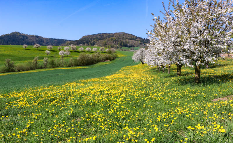
The second orange section is the most beautiful, with cherry trees against sweeping views of Rigi and the lake and hills filled with dandelions. If you only want to visit this section, you could hypothetically park on the lake at Lothenbach (I don’t know if the parking spaces are public) and hike 800m straight up the hill to the viewpoint. I wouldn’t particularly recommend that, but I guess it’s possible if you are short on time and long on legs.

On the trail
From the Fridbach train station, walk up the hill starting on this little Fridbachweg.

My boys stopped at this little playground and I thought they may never leave.

The small path drops you on this road. Turn right and follow the road until it turns into a path.

Here’s the path, for walkers and bikes.

Long views toward Mt. Rigi hidden in the clouds.

Near the Oberwil train station, you turn left and walk up this road.

This is one of the prettiest part of the trail.

It wasn’t quite peak bloom but still very nice.

Then keep walking up the hill and up these stairs.

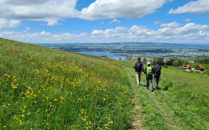
You’ll join this gravel path and get a great view back down toward the lake.
There’s a picnic area here with a fire pit and the last station on the WaldParkours activity trail. We want to come back and do that trail later.

Follow the path to the south, with the lake on your right. There are a couple turns here and there, it helps to follow the map on your phone.

The last open view before you enter the forest.

Then a long stretch in the woods.

A winding path that goes up and up.

Follow signs to Walchwil.

A few stairs down and climbing back up.


Another highlight, this unique rounded field with a view. Perfect place for a picnic.

Then you quickly dip through the forest then emerge to the best views of the trail with Mt Rigi in the background.

Then my camera and phone ran out of batteries and I missed taking any more photos of the best part of the trail. Aaaaaahhhhh! So I’ll try to go back asap and get pics of this last part of the trail. So sad and so sorry.
After a few minutes, you connect to the Walchwil village but you are still way up on the hill. When you join the main road through town, turn right and walk down to the Walchwil train station.
That’s all for now. I hope you make it to this trail during peak bloom. Enjoy!
See also: 15 Spring flower trails in Switzerland


7 responses
Running out of battery is so cruel. On the other hand it gives you a good reason to come back.
Thanks for all the pretty pictures and helpful tips, I will certainly keep them in mind.
Have you heard of the cherry storm in August?
Never heard of the cherry storm, guess I have to go look it up. Thanks for the tip.
Hello anyone can help you ne let us know if it is possible with stroller ?
Thank you
Khadija
It’s possible with a stroller only for the first half of the trail walking south from Fridbach. And the end of the forest section, there are a few sections with stairs and the path narrows to a lumpy dirt trail.
Thanks for the extra info. I’ve added it into my calendar. Can’t miss it this year!
Opposite direction (oberwil to walchwil) is the best view.
Thanks for the tip. It’s almost time for this trail, can’t wait to do it!