This countryside hike near Zug is a great choice for spring, wandering up and over hills filled with wildflowers. If you time this hike just right, you can enjoy cherry blossoms at the many farms you pass.
Although the trail is quite long, it is easier than you might imagine, with only one short uphill climb. I have a shorter obstacle-free alternative below that gets many of the same views but is suitable for strollers and wheelchairs.
Contents
| Location: | near Zug, central Switzerland |
| Trail Start: | Unterägeri, Zentrum bus stop |
| Trail End: | Zug, Postplatz bus stop |
| By car: | Park in Zug (Parkhaus Vorstadt – Schmidgasse 3, 6300 Zug), then bus to trail start From Zürich or Lucerne 35 mins |
| By public transport: | Bus stop: Unterägeri, Zentrum From Zug 21 mins, Zürich or Lucerne 55 mins |
| Trail: | 11.6 km, about 3.5 hrs |
| Elevation: | highest point 860m |
| Technical skill: | easy |
| Condition: | partially paved and dirt roads, partially narrow dirt footpath alternative below for strollers |
| Stamina: | moderate, 200m up, 500m down |
| Open: | April – Oct |
| More info: | www.zug-tourismus.ch • webcam |
Hiking map
This trail is part of the long distance Alpine Panoramaweg, with 510 km broken into 29 stages. We did stage 9, a one-way trail from Unterägeri to Zug. We chose to walk in this direction because it is less uphill. But if you have knee problems, you might prefer the opposite direction so you are climbing up the steep section. It took us 3hr15 to complete the trail.
See trail map on Komoot • SchweizMobil • OutdoorActive
Most of the trail is on paved low-traffic country roads, which didn’t bother me as I thought it would. About 1/3 of the trail is on lumpy dirt & grass foot paths, some quite muddy and torn up from cows walking on the trail. Best to have good hiking shoes that can get wet and muddy.
Shorter version
In Unterägeri, there is a 7km obstacle-free loop on paved roads that is partially on the same path as the Alpine Panoramaweg, a good alternative with great views. It’s suitable for wheelchairs, strollers and even kids scooters. See details here.
Getting There
This trail is located in the Lake Lucerne region, south of Zurich. It’s a one way trail, but there is a public bus connecting the two ends.
By public transport: The trail starts at the Unterägeri, Zentrum bus stop. If you are coming from Luzern or Zürich, take a train to Zug main train station. Then take Bus 1 to Unterägeri, Zentrum.
By car: We parked in Zug and took a bus to Unterägeri to start the trail. We parked at the Parkhaus Vorstadt (Schmidgasse 3, 6300 Zug), near where the trail ends. Parking costs CHF 1.50/hr. We paid a total of CHF 13.50.
From the parking, it’s a short 2 min walk to the Zug, Postplatz bus stop where we caught Bus 1 to Unterägeri, Zentrum. This bus runs every 15 mins and takes 20 mins to reach Unterägeri. The one way bus ticket costs CHF 7 (normal Swiss travel card discounts apply). You can buy the bus ticket at a machine at the bus stop or on the SBB mobile app.
If you want to park in Unterägeri instead, there is a parking lot near the trail at Seestrasse 61, 6314 Unterägeri. In that case, at the end of the trail, you could take a bus back from Zug to Unterägeri.
Planning your day
When to go
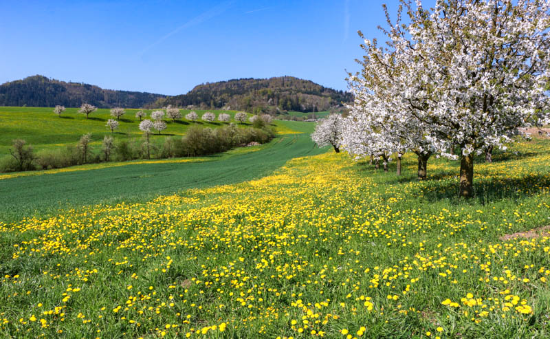
This trail is best from mid April through November, assuming no snow. We did this trail the third week of May, which was a couple weeks too late for the cherry blossoms but just right for wildflowers.
Where to eat
After about 6 km (2 hrs), you’ll reach Alpwirtschaft Brunegg, a farm with a restaurant. We waited to eat until we finished the hike in Zug, where there are lots of restaurants and cafés. There are a couple picnic areas along the way.
What to wear
Check the forecast and wear clothing appropriate for the weather. If there is a chance of rain or clouds, bring warm and waterproof layers in case the weather changes. Bring a sun hat and wear sunscreen. The terrain is quite easy, mostly on roads.
But some sections are on dirt and grass, which was quite wet and muddy when we were there. So although you could wear any comfortable walking shoe, you might prefer waterproof hiking shoes that can get dirty. Hiking sticks aren’t necessary.
What to bring
Bring 1-2 liters of water per person and enough food to sustain you through the hike. You can optionally stop for refreshments at the restaurant halfway.
Photo story of the trail
Starting in Unterägeri
The bus drops you in the center of town. If you need supplies, there are bakeries and grocery stores near the bus stop. We bought sandwiches and treats at Cafe Brändle next to the bus stop. There is a Coop grocery a few more meters down the road at Waldheimstrasse 2, 6314 Unterägeri.

The trail starts on Binzstrasse, walking through the village to reach the countryside. The whole trail is well marked with the little green square signs, labeled Alpine Panoramaweg.

After a few minutes on the road, you reach the farmland.

A few informational signs along the way.

Lots of trees that blossomed a couple weeks earlier.

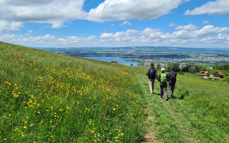
Lovely views back towards the Ünterägeri lake.

Walking by lots of farms.

Although much of the trail is on roads, some is on footpaths like this.

The trail easy to follow, but there are lots of forks in the road. So keep an eye on the trail signs.

Remember you following the green square with the #3 – Alpine Panoramaweg.

So much yellow!

Be respectful to the farmers and don’t walk out into the flower fields. It ruins the grass, which is used to feed cattle.

Heading into the forest.

More yellow.

Another fork in the road. A big group of hikers went straight, so we weren’t sure.

But we followed our green #3 sign and it was correct.

Another footpath into the fields.

Pretty as a picture.

So Swiss, right?

Joining the road again.

Out into the fields again.

Hiking over the big hill
Now we climb uphill, the only slightly tough part of the trail.

Starts on a very lumpy path.

Passing Alpwirtschaft Brunegg, a farm with a restaurant. A little too early in our hike for lunch though.

A bit more uphill, not that difficult.

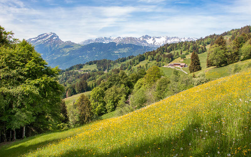
Now easy walking across big fields with long views across the countryside.

Descending the road.


Passing another farms.

They had a little self-serve shop, pay with cash or Twint. I got some cherry juice.

Another pretty footpath. It was quite muddy after recent rain and two of us slipped and fell into the mud.

More lush wildflowers.

More farms.

Descending to Zug
Now Zug and the lake come into view.
Heading into the forest again.

Starting to reach civilization as we pass this church.

Keep following the green signs that lead you into Zug old town.

Almost to Zug.

Reaching the Zug old town.

We grabbed a picnic lunch and ate lakeside.

Views down Lake Zug.

All done, just a short walk to our car parked in a garage near the lakeside. Hope you like this hike!
Video of the trail
Here’s a video of our hike here in May.


4 responses
Con you do the hike the other way around, starting from Zug? Or are the views better in this direction?
Yes, you can hike in either direction. I would prefer hiking towards Zug for the nice views down to the lake.
Thank you Tanya!
I did this hike yesterday (17 July 2025) and it was perfect! For the ones who are considering, here is my experience:
– I did the same direction as described above and the scenery is awesome.
– I had eggs in that bakery at the starting point 🙂 and bought snacks at the Coop (right across the street).
– After 1.5 hours, I gave a break at that restaurant for coffee and toilet. Since it is a farm restaurant expect many many flies. I would not try eating there.
– If you miss this in Spring, you can do this on a cloudy summer day too. As knowing that most of the hike involves small roads, and not much shade, I was not very excited about this hike but it was great! Probably because I did this on a weekday (I was the only one on the path) and it was a light cloudy day. The heat was bearable as it was cloudy but still warm enough to dip my feet in the lake at the end of the hike.
– The finishing point in the Zug old town is a small public beach (means a small green area beside the lake), so bring your swimsuits and take a swim.
– Normally my knee hurts when descending but the descend is not so steep, so that was OK too.
– I am thinking of taking parents and guests who are not very fit but still want to have some hiking experience. It is not a demanding hike but still gives a good feeling of Swiss meadows and mountains.
Thanks again Tanya!
So glad you enjoyed it! Loved reading about your experience and tips. Wishing you many more happy adventures.