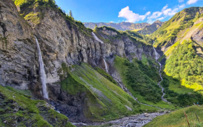
These waterfalls near Locarno are a fun place for locals to cool off and sunbathe under the hot Ticino sun. To reach the falls, it’s a short walk through the Maggia village and up the river through the forest.
The path leads you to the base of the falls, where you can swim in a chilly pool and take the best pics. If you’re lucky, you’ll get a rainbow like we did.
Note: Best not to visit the falls after heavy rains in the region as the water flow can be dangerously high. There are also times when dams above the falls release more water, also causing dangerous conditions. Inform yourself of local conditions before visiting.
| Region: | Ticino |
| Starting point: | Maggia, north of Locarno |
| By car: | Parking: Via Cantonale Vecchia 56, 6673 Maggia 20 mins from Locarno, 1hr from Lugano |
| By public transport: | Bus stop: Maggia, Centro 30 mins from Locarno, 1hr15 from Lugano, 3hr30 from Zurich HB |
| Trail: | 800m from bus stop |
| Time: | about 15 mins |
| Difficulty: | easy, 20m up & down |
| Condition: | dirt footpath, stairs, rocky |
| Elevation: | highest point 850m |
| Open: | best May to August |
| Cost: | free |
| Extras: | near the Maggia bus stop – grocery store, café, and pharmacy |
| More info: | ascona-locarno.com • nearby webcams • forecast |
Gallery


Location
The Cascata del Salto falls are located in the Maggia village north of Locarno, in southern Switzerland (see on Google Maps). The falls are a short walk from the Maggia bus stop.

How to get there
By public transport:
From Locarno, ride bus 315 to Maggia, Centro. Using the hiking map below, follow the brown Cascata del Salto signs to the path.
By car:
Drive to Maggia. There is a small parking lot at the community center – Via Cantonale Vecchia 56, 6673 Maggia. Walk to the main road and turn right, following the map below to the waterfall path.
Hiking map
This map shows directions from the Maggia bus stop to the falls viewpoint.
If you want a longer hike, you could do the Giro della Valle del Salto trail that starts in Maggia. It’s 9km loop in the valley above the waterfalls.
Photo story
From the bus stop, turn right into the village and left when you see this sign. Follow the brown signs labeled “Cascata del Salto.” There are only a couple signs, so don’t get worried if you don’t see them. Just use my above map to make your way.

Walk down the road and cross the big car bridge over the river. From the bridge you can see the waterfall in the distance.
After the bridge, you’ll see this church. Turn right and follow the road past a few houses.

We are following that road towards the forest.

Then turn right following the path along this rock wall. Do not accidently walk into a private garden.

The path continues through the forest on a small footpath.

Going uphill a bit, but not too steep.

You exit the forest at these big boulders. Climb the steps to access the falls.

You can get great pics from the rocks without having to walk down to the river. If you want to swim, you’ll need to walk down and across the dam to enter the pool on the far side. That’s the safest way to get in.
You can see people getting ready to swim near the dam. It’s safer to store your stuff and get read on the side we are on.
The water was chilly but not icy cold like other Swiss rivers we’ve been in. The first pool near the dam is not super deep. But the second pool near the falls is much deeper. There is a small cave to the left where some people swam to.

We took our pictures around 16:30 in the afternoon in late June. That might be a good time to catch the rainbow effect.