This amazing hike is all about the views, admiring the famous Bernese Alps as you wind your way around the mountain, then down into the Sefinen river valley that leads back to Gimmelwald. This was a long one for our kids, but they managed fine and even enjoyed themselves. We didn’t set out to do this hike, but once we rode up the cable car, we quickly changed our plans and decided to walk down. So happy we did.
| Location: | Jungfrau Region, Berner Oberland, Switzerland |
| Address: | Schilthornbahn cable car Lengwald 300B, 3812 Wilderswil |
| Car: | 2hr from Zurich to Stechelberg Parking GPS: 46°33’20.3″N 7°54’04.4″E |
| Train: | 2hr45 from Zürich HB to Stechelberg, Schilthornbahn |
| Trail: | 11 km, about 4-5 hours |
| Elevation: | highest point 2675m, 1441m descent |
| Condition: | narrow dirt alpine trail |
| Skill: | moderate, some steep switchbacks |
| Open: | mid June through October |
| More info: | www.schilthorn.ch |
Gallery


Hiking map
Here is an hiking map of the Gimmelwald / Schlilthorn area. This hike starts at Birg (2683m), one stop before the top of Schilthorn. The hike descends 1300m over almost 11km to Gimmelwald, where you can catch the cable car back down to the valley.
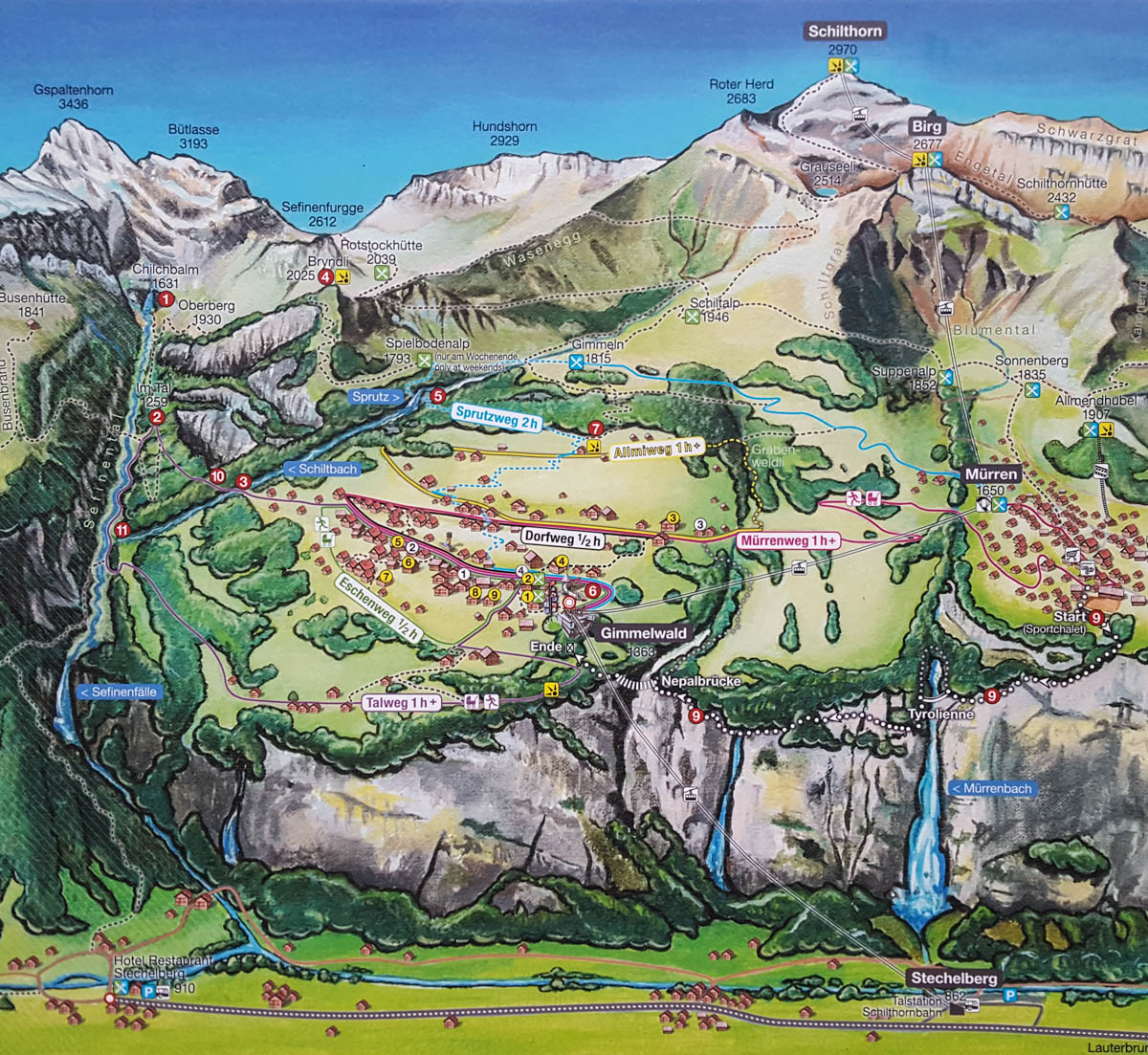
Here is an interactive map of the trail.
See map on Komoot • OutdoorActive
The hike is not technically difficult but it is long with lots of downhill and steep switchbacks. I recommend taking hiking sticks for balance. No strollers. We did this hike with my 9 and 12 year old and they did fine, but it was definitely a workout.
There is one hut/restaurant in the middle of the trail at Rotstockhütte, but otherwise, no services or water along the trail. There is only one picnic area with a fire pit near the end of the trail, next to the river. So bring a picnic instead, not something to grill.
Before starting your hike, ride to the top of Schilthorn, enjoy the view and James Bond attractions. Then ride back down to Birg, where you can do the short “Thrill Walk” along the cliff. See my Schilthorn Observation Deck post for more details about both these areas.
There are many hiking options in this area, but I saw the other trails leading from Birg and this one definitely looked the best. You can optionally start this hike at Schilthorn and hike down to Birg, adding a few km to your hike.
How to get there
By car: Drive to Lauterbrunnen and continue driving up the valley to Stechelberg. Park in the metered lot. We paid 8 CHF for about 8 hours.
By transit: Take the train to Lauterbrunnen, then a bus to Stechelberg, Schilthornbahn. The bus drops right at the cable car station.
Planning your day
Tickets
For this hike, you need a one way cable car ticket from Stechelberg (or Mürren if you already in that village) to Birg. You can optionally ride all the way up to the Schilthorn viewpoint before returning to Birg for the hike. That ticket is more expensive.
The hike ends in Gimmelwald. Most people will ride the cable car down to Stechelberg, where you either parked your car or are catching the bus to Lauterbrunnen. You can purchase this ticket at the cable car station. If you are staying in Mürren, you’ll need a one-way cable car ticket up to Mürren.
See current prices and timetable on the Schilthorn website.
Discount with Swiss Travel Pass, Jungfrau Region Pass, Berner Oberland Pass, SBB GA and SBB Half Fare.
Opening Times
The gondola runs from Stechelberg to the Schilthorn about every 30 mins from 7:25 to 16:25, last descent 18:03. The cable cars from Murren and Gimmelwald to Stechberg run much later, so you have plenty of time to complete your hike.
The hiking season is about mid-June through October, but check the website and webcams to make sure the trails are clear of snow before heading out.
The Schilthorn complex and viewing area is open year round, except for brief maintenance periods in April, late November and early December.
Photo story of trail
Schilthorn Observation Deck
At the top of the Schilthorn, you’ll find an outdoor observation deck, a restaurant, gift shop, James Bond “Walk of Fame”, etc. For more pics and details, see my Schilthorn Observation Deck post.

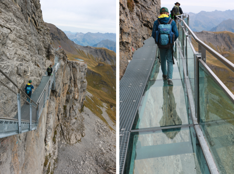
Birg “Thrill Walk”
Ride back down to Birg. Before heading on the hike, follow signs to the Thrill Walk. The Skyline Walk is the observation deck above. The Thrill Walk descends metal stairs below the restaurant onto a walkway built into the side of the cliff. It’s totally awesome! One part of the walkway has a glass floor. Another part has a suspension wire to walk across, with a safety net. Another part has a cage you can crawl through. See my Schilthorn post for details.
Starting trail from Birg
Ready to hike? Follow trail signs to Rotstockhütte, the trail starting on a dirt road below the restaurant. Make sure to head to your left and not down the valley on your right.


As you turn left, you’ll see the lake below. Head down on the dirt path.

Looking back up to the Birg station.
Skipping rocks at the lake. If you only wanted a short walk, this would be a nice place for a picnic, then head back up to Birg and ride down.

Walk past the lake and continue down the trail.

Now for lots of steep switchbacks. I was happy to have my hiking sticks on this part.

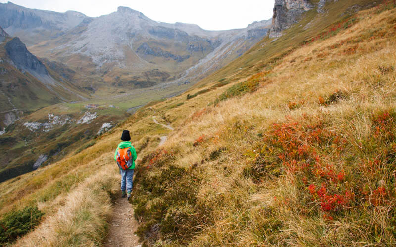
This was probably my favorite part of the trail, easy going and big views. I’m sure it’s even better in summer when it’s all green instead of yellow.

One tricky part of the trail where we had to climb over rocks.
Looking back up the trail.

Heading up to the ridge.

Taking a break on some benches on the ridge. One trail follows the ridge, then down to Murren. We headed down the hill to the right.

Descent to Rotstock hut
Still following signs to Rotstockhütte.

Heading down these grassy fields.

When the trail hits a “T”, turn right and head up these valley.

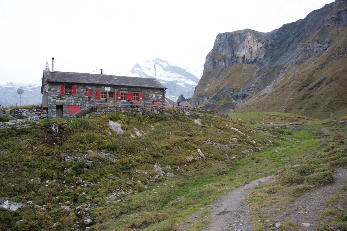
That’s Rotstockhütte in the distance.

Hello Rotstockhütte. I felt like sleeping over and finishing the hike the next day but we didn’t have any of our sleepover stuff.
Switchbacks down to river
Now it’s time to follow signs to Sefinental and Gimmelwald. Follow the trail on the left/north of the hut, following the river down into the valley.

Now right along the river. It was very muddy and slippery when we were there.

Once we entered the forest, it got steep again, lots of switchbacks, a long way down into the valley.

Almost down the mountain.

Pretty. pretty, pretty.

More forest.

The cows had been brought down the mountain earlier that day and were all huddled up by the river.

We had to pass some cows that were standing on the trail. But we did so safely.

Walk back along river
More easy going on this path by the bigger river in the Sefinental. We had hoped to build a fire on the river, but there wasn’t easy access to the river until the picnic area much later.

Forest sections.

Near the end of the trail, the path was blocked because people were using the gun shooting range, which shot over the trail. Very unsafe. There is a detour that goes very steeply up the mountain for a bit and around the shooting range. We just waited until they were done shooting. In Gimmelwald, the shooting schedule was posted near the trailhead. But since we were hiking the opposite direction, we didn’t see the warning and schedule. Those numbers below are the targets.

We stopped to grill at this official Schweizer Familie Feuerstelle, which had wood, benches, tables and even tables under cover in the little hut.

We chose to build our fire next to the river.

A fun place to explore while you wait for the food to cook.

Some waterfalls we passed.

Leaving the Sefinental valley behind as we enter Gimmelwald.

Ending in Gimmelwald
The trail sign at the entrance to the Sefinental valley, on the outskirts of Gimmelwald.

A cute “honesty” shop in Gimmelwald.

A nice playground next to the Gimmelwald cable car station.

Don’t forget to Pin this for later.


10 responses
Where is the memorial plaque to Alice Arbuthnot, killed by lightning on the Schilthorn and whose memorial is in Murren church ? Thanks
I don’t know. But maybe I’ll look for it next time I go.
Thanks so much for your website and this post in particular! We just got back from a trip to Switzerland with our two kids, ages 8 and 10, and the information you provided was really helpful and appreciated. This hike was relatively easy for the parents and our 10 year-old, but a bit of a challenge for our 8 year-old. If you do this hike with your kids, I think it is important to remember that, at least for Americans who might not be used to substantial, steep, alpine descents, younger kids might have difficulty (or get scared), whereas it might be less of a big deal for Swiss kids used to mountain hiking. We had a blast, though, and the views were spectacular (we had a sunny day in the summer and it was amazing).
That’s definitely a tough hike, good job especially for the 8 year old! My knees were killing me after that last descent to the river. Perhaps I should include a stronger warning in my post? Glad you had a good time. Hope you can come again sometime.
Firstly, thanks for your wonderful blog. It is helping me so much in my upcoming trip to Central Europe and of course Switzerland. May I know which months you took this hike? I’m just wondering if I would be able to see those mountains with their beautiful snow caps too. Thanks!
Would you recommend hiking up the same path you went but going all the way up to the schilthorn and then just taking the cable car down? I know you had your kids, but for a few guys in the early 20’s do you think it would be doable/enjoyable?
Do you recall how long it took you to hike down from Birg to Gimmelwald?
Hi Missy, it took us about 4 hours, walking pretty slow. It’s a lot of downhill, so bring sticks and take it easy on your knees. Good luck!
Wow that looks amazing! Thank you for your detailed post! I have a few further questions for you. When did you do this hike (what time of year)? And are there many steep drop offs on either side of the trail? I’m trying to see if there is a path where if my clutzy butt trips, I am not in going to fall off a mountain. Thanks so much!
I don’t recall any steep drop offs on the trail. There are a couple sections with steep switchbacks that have some tricky footing. Best to bring hiking sticks for stability but you certainly won’t fall off a cliff. Good luck!