This epic trail stretches between Grindelwald First and Schynige Platte mountains in the Jungfrau Region.
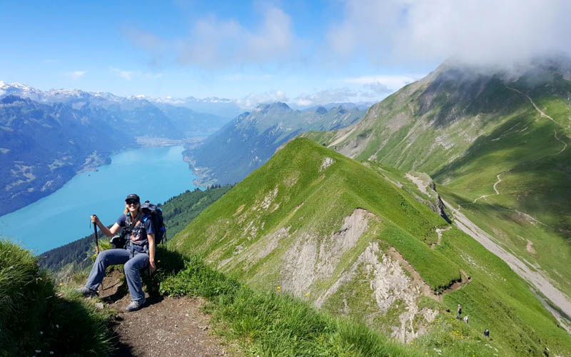
Along the way, you’ll walk along a scenic ridge overlooking Lake Brienz, visit two mountain huts, climb the Faulhorn peak, pass the Bachalpsee lake, and end at the First Cliff Walk.
It’s a popular choice for experienced hikers, both locals and visitors, so you won’t be alone the trail. But there’s plenty of room to spread out and enjoy the high elevation views in peace. It’s a we suggest getting an early start and keeping track of your pace so you make the last gondola down the mountain.
The hike is long and tough, with steep climbs and rocky terrain. But the path is well built, clearly marked and no particularly exposed or dangerous. It takes all day, so get an early start so you don’t miss the last gondola at the end.
Note: This hike is stage 15 of the long distance “Via Berna” trail, which circles the entire Bern canton.
| Region: | Jungfrau Region, Switzerland |
| Location: | Start: Wilderswil train station (Hauptstrasse 2, 3812 Wilderswil) End: Grindelwald Firstbahn (Dorfstrasse 187, 3818 Grindelwald) |
| By car: | From Interlaken 8 mins, Lauterbrunnen 15 min/Grindelwald 25 mins, Zürich 1hr45 |
| By public transport: | From Interlaken 6 mins, Lauterbrunnen 15 min/Grindelwald 32 mins, Zürich 2hr05 |
| Trail: | 17.2 km (10.6 mi) one way |
| Time: | about 6 hours |
| Difficulty: | moderate, red/white mountain trail, Swiss trail rating T2 |
| Condition: | narrow rocky footpath, stairs, not exposed, no strollers |
| Elevation: | highest point 2620m |
| Open: | July to mid-October |
| Cost 2025: | about CHF 75 for mountain transport Free with Jungfrau Travel Pass. Discount with Swiss Travel Pass, Swiss Half Fare Card, and Berner Oberland Pass. |
| Extras: | restaurants at both ends, two mountain huts along trail |
| More info: | www.jungfrau.ch • Faulhorn webcam • forecast |
Gallery


Hiking map
This is a one way trail between Schynige Platte and Grindelwald First.
Along the trail, there are two mountain huts (at Faulhorn and Männdelenen) where you can get drinks, simple meals and use the WC (for a fee if you are not a paying customer).

Trail map
Here is an interactive trail map.
See trail map on SchweizMobil • OutdoorActive • Komoot
Which direction to hike
I prefer hiking from Schynige Platte to First. Because the First gondola is open later and runs continuously, you have less stress about your arrival time. We also prefer the views in this direction, particularly as you descend to the Bachalpsee at the end.
If you prefer to hike the reverse direction, from First to Schynige Platte, see trail map for that version.
Trail conditions
The trail is a red/white mountain trail, a narrow footpath, sometimes rocky with tricky footing on loose rock here and there. But easy to follow and not dangerous for the average hiker.
How to get there
This trail located in the Jungfrau Region of Switzerland. It’s a one way trail and you can hike in either direction. But I’ll assume here that you are starting the hike at Wilderswil / Schynige Platte.
By train:
Take a train to Wilderswil, Bahnhof and transfer to the mountain train up to Schynige Platte.
The hike ends at Grindelwald First, where you ride a gondola down to Grindelwald village. Then a short bus or walk to the Grindelwald, Bahnhof train station. There you can catch a train to Interlaken or Lauterbrunnen.
By car:
It’s easiest to park your car in Wilderswil at the big parking lot as your enter the town – see on Google Maps. From the parking, it’s a 5 min walk to the Wilderswil, Bahnhof where you’ll board the mountain train up to Schynige Platte.
The hike ends at the Grindelwald First, where you ride a gondola down to Grindelwald village. Then a short bus or walk to the Grindelwald, Bahnhof train station. It’s a 35 min train ride to Wilderswil where you left your car. The train leaves every 30 mins.
Planning your day
Ticket prices
You’ll need a one-way ticket on the Grindelward First gondola, a one-way ticket on the Schynige Platte mountain train, and transport in the valley between your end and start point.
You can buy these tickets at the ticket desk at each location (with cash or card) or online beforehand (recommended for busy days).
All transport is free with Jungfrau Travel Pass. Discount with Swiss Travel Pass, Swiss Half Fare Card, and Berner Oberland Pass.
Children 6-15 are half price. Children under 6 and children with the Swiss Family Card or SBB Junior Card travel free.
Operating Times
This trail is typically open from early July to early October. But check current snow and trail conditions before heading out. We’ve seen snow on this trail through the third week of July and as early as the first week of September.
The Schynige Platte mountain train typically runs from mid June through mid October. The train runs about every 40 mins. The first train up is 7:25 and the last train down is 17:53. The train ride is 52 mins. See current operating times here.
The Grindelwald First gondola is open most of the year. In summer, the first ride up is at 8:00, last ride down at 18:00. The journey takes about 30 mins. Check the current schedule.
Sample schedule
On our last visit, it took us 5hr15 of walking time and 7hrs total time on the trail. As a day trip from Zurich, here was our rough schedule.
- We left Zürich by train at 6:00
- Arrived in Grindelwald at 8:40
- Got on the First gondola at about 9:00, on the trail about 10:00 (after doing the cliff walk)
- Made it to Faulhorn by 11:45, ate lunch, back on the trail at 12:45
- Arrived at the Männdlenen hut at 13:45, short dessert break
- Arrived at Schynige Platte ridge around 15:45
- At the Schynige Platte train station by 16:30
- Took the 17:01 mountain train down to Wilderswil
- Trains back in Zürich, arriving home at 20:30.
What to wear and bring
This is a mountain trail with rough terrain. Definitely wear sturdy hiking shoes with good tread and bring hiking sticks for stability.
Although you can buying drink and food at the huts along the way, definitely bring 2 L of water to last you the full day.
Even for a good forecast, we bring at least a fleece and waterproof jacket in case the weather changes during the day.
Where to stay
If possible, I would suggest staying in Grindelwald the night before this hike, so you can easily get on the first gondola of the day at 8:00. There are lots of accommodations in Grindelwald.
On a budget side, there is a youth hostel in Grindelwald that has family rooms. For a nicer stay, we really enjoyed the Boutique Hotel Glacier, which had fantastic views of Eiger. It also has a fantastic restaurant serving a beautiful, delicious 7 course meal (a treat for our wedding anniversary). I would definitely go back there.
If you are staying in the area for more than 3 days, I’d suggest staying somewhere more central like Interlaken that enables you to more easily access a variety of destinations, not just Grindelwald. In Interlaken, I’d choose something within a 5-10 min walk of the Interlaken Ost train station to reduce travel time.
On the budget side, there is the Interlaken Youth Hostel, which also has rooms for families and single travelers, not just dormitories. For mid range, you might try Hotel Interlaken or Hotel Weisses Kreuz.
Wilderswil, at the end of the hike, would also be a good option, only a 3 min train ride from Interlaken Ost, 38 min from Grindelwald. Accommodations tend to be more affordable here than the other more popular villages. Historic Hotel Steinbock is a relaxed guesthouse on the river that looks adorable. People seem to enjoy the restaurant and fantastic views from the Jungfrau Hotel.
Photo story of trail
In this photo story, we start at Grindelwald First and end at Schynige Platte. But you can hike the opposite direction.
1. Riding up to Grindelwald First
The gondola shown here takes about 25 mins to reach the First station at the top.

When you arrive, make sure to do the short cliff walk below the restaurant. It only takes a few minutes and will give you some thrills and great pics. It loops you back to the gondola station where you can start the hike.

2. Hike to Bachalpsee
From Grindelwald First, follow signs to the Bachalpsee, which is on this wide service road. The first bit climbs up and you’ll see everyone huffing and puffing.

There is one short rocky section as shown below. But otherwise, the trail is smooth dirt.

The trail splits from the road here. You can take the footpath to the right to avoid going down and back up again.

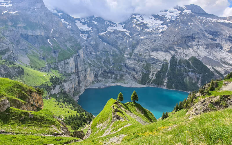
3. Arriving at the Bachalpsee
It’s only 3km to the Bachalpsee, which should take about 45 mins. The lake is separated into two parts. This is the first smaller section, which can get crowded because everyone sees this first and stops to take a break with the mountain views.
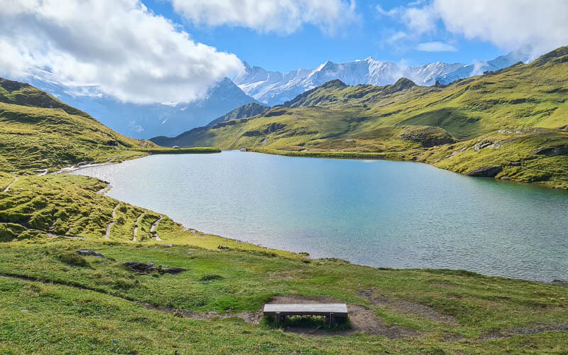
I think the second one is a bit prettier and definitely less crowded. Your trail continues on the right side of the lake.

The view from the far side of the lake is even better.

4. Hiking up to Faulhorn
Now a tough but short climb up lots of steep switchbacks, gaining about 400m over about 2.5k. This was the most difficult part of the trail for us, but still not that bad.

As you climb up the mountain, turn around frequently to enjoy the lake view. This is one reason I think hiking the other direction might be preferable.
After about 1hr15 hiking, we saw this sign. Still a long way to go to Faulhorn and Schynige Platte.

Reaching the top of the long climb with great views to the Eiger and Männlichen across the valley.
Looking forward to where we are hiking next.
The trail flattens out and now you can see the Faulhorn peak ahead of you. You don’t have to climb up to the peak. The main trail skips the peak and continues to your left. But you should definitely climb up – it only takes about 10 mins and the views are worth it.

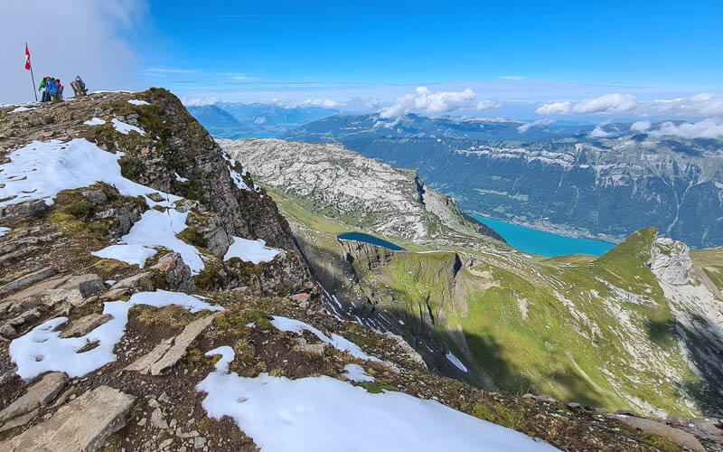
View from the top of the Faulhorn, north toward Interlaken.
Looking down from the Faulhorn back at the trail we just did. You can see it cutting through the snow along the cliffs.

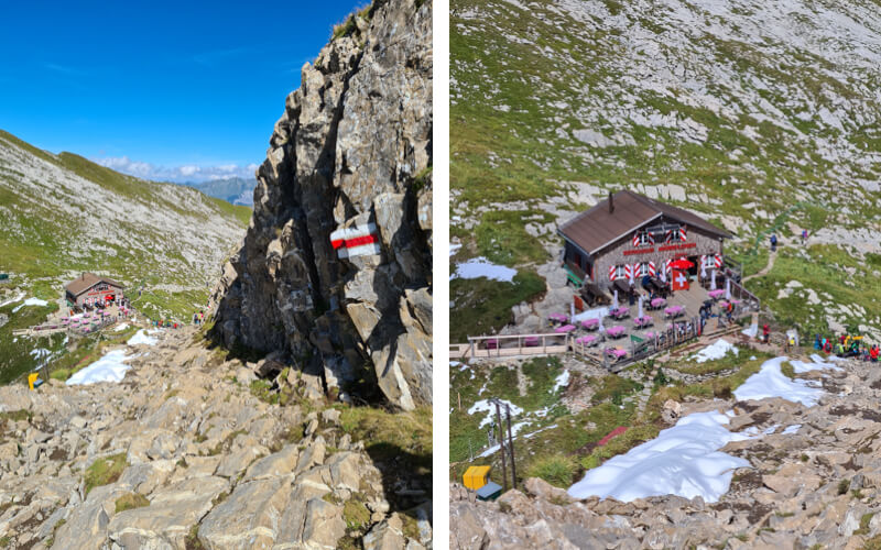
We ate lunch up here but I failed to take a pic of the Berghotel Faulhorn restaurant. It’s a simple mountain hut type situation, with tables outside with a view and inside tables for colder days. The menu is simple with soup, rösti, pasta and hot & cold drinks. You can pay with cash or card. The menu warns that hot meals like rösti will take 20 mins, good to know if you are in a hurry. We got soup and it came out fast.
5. Hike to Männdlenen hut
From Faulhorn, we hiked back down the way we came because of the snow. But there is a trail down the other (left) side of the peak that joins the main trail.

Now the trail is rather easy for the next few km to the Männdlenen hut. There are some rocky sections but mostly downhill and no long climbs.

Looking back up the trail to Faulhorn on the left.
A nice flat section for a bit.

Lots of cliffs around here but the trail isn’t dangerous.

Lots of loose rock here. I was happy to have my sticks and even then I still slipped and fell once on a wet snowy patch.

Long downhill to the hut with loose rock and some tricky footing.

Arriving at the Männdlenen hut and excited to have dessert here.
6. Continuing to Schynige Platte
Back on the trail, now “just” 2 hours to Schynige Platte, about another 7-9 km depending on which trail you take at the end.

This section starts out very rocky and a bit slippery. Watch your step.

Then traversing under some peaks. I was worried some rocks might fall on us. Don’t forget to look up at the cliffs above you.

The first cows we’ve seen on the trail.

Coming around the corner to see the Lauterbrunnen valley in the distance.

Looking back at the peaks you just walked around. Another reason I think walking the opposite direction would be nicer.
The trail keeps traversing around the mountain, a little up and down but not too much.

7. Along the Schynige Platte ridge
Now the last section, along the Schynige Platte ridge which I’ve hiked with the kids twice before, just a short 6k loop you can read about here.
Very grassy here, a much different look than the rest of the trail.

At this point, the trail forks. Both lead to the Schynige Platte train station. But fork to your right to stay on the ridge. It’s a bit longer but worth the effort. The fork to the left wanders through the meadows, easier and shorter than the ridge.

You are almost there! Check your watch and see if you need to hurry for the train.

Staying on the ridge adds another short climb to a viewpoint but it’s worth it to get these views, I think.
8. Riding down to Wilderswil
The trail ends at Schynige Platte where you’ll find a restaurant, WC and the train station. You can buy your train ticket here if you don’t have it already. Hopefully you didn’t miss your train and can enjoy the next 52 mins slowly chugging down the mountain.


7 responses
Hi Tanya
Lovely post with all the required information. I am planning to do the hike in first week of July 2025. I noticed that the trail is high altitude all the way. Does it make much difference? Kind Regards Dev (Australia)
The first week of July could be a little early for this one. We did it on July 11 one year and there were large snow patches on everything above about 2200m. But lots of people were hiking on it, so the snow was packed down and not too difficult for walking.
Enjoyed reading about your adventure! I’m booked to go to Grindelwald area mid September with my girlfriend. We are booked for one night at the Berg Faulhorn but now I have second thoughts because if there is snow then I’m out of my comfort zone. (I had a bad experience going up Refugio Lagazuoi on Via Alta 1 because of the snow).
Is there an alternative trail to avoid Faulhorn Summit?
We plan to walk from Schynige Platte to First and overnight at the Berggasthaus First (another option).
This trail is usually snow free through late September. If there is a snow storm in September, it usually doesn’t stay too long. If there is snow on the trail, it would be on many sections of the trail, not just the Faulhorn peak. So avoiding the peak wouldn’t really solve your problem. If there is a lot of snow, you would really need to select another trail. I would ask at the gondola stations about the trail status or check the Jungfrau Region website.
Hi Tanya,
Your entire blog has been so helpful in planning our hiking adventures on a recent trip to Switzerland. In particulary, this entry, with detailed directions and photos of every decision point, gave us the confidence to change an out-and-back hike from First to Faulhorn into a through hike to Schynige Platte while we were already on the trail. It ended up being one of my favorite days of the trip. Thank you so much!
Wow! You are so ambitious. So glad I could help you have a fun hike. Wishing you many more happy adventures.
Hi in late September 2021 – I did the hike from Grindelwald to Wilderswil without taking the train or the Gondola.
I left Grindelwald at 8:30am and made my way up to First – then the Faulhorn followed by the Schynige Platte.
I found the descent down to Wilderswil a bit tricky as parts of the path were bit wet and slippery but made it to the station at around 7pm.
I was extremely tired but the weather had been perfect and I got some great pictures.
I had wanted to do the walk since 2002 and finally had the opportunitty
.