
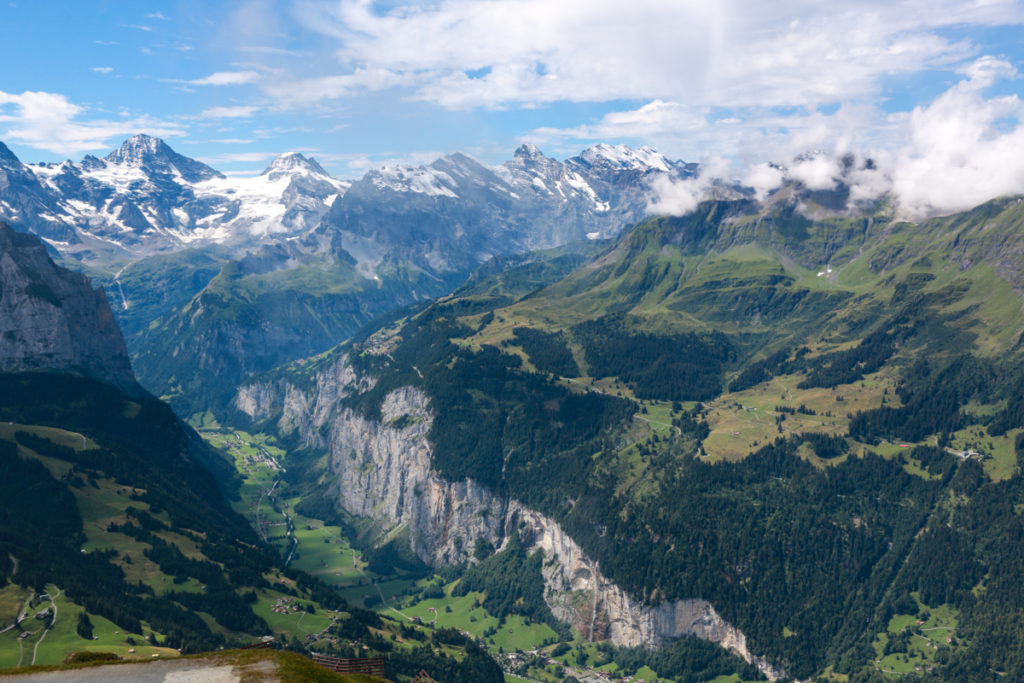
This mountain trail traverses the cliffs above the narrow Grindelwald Glacier Canyon, leading to the Bäregg mountain hut. From there, you get a fantastic view of the Ischmeer glacier, while enjoy refreshments at the hut.
Best for experienced hikers with good fitness and a head for heights as the trail has a few sections with steep cliffs on one side. That said, I found the trail well built and not particularly dangerous. Although we saw a few families on the trail, with kids as young as six, it wouldn’t be my first choice with kids because of the cliffs.
After the hike, you can add on the summer toboggan and “fly line” amusements next to the cable car. It’s a rather short hike, but if you want to hike longer, you can skip the cable car.
| Region: | Grindelwald, Jungfrau Region, Switzerland |
| Starting point: | Pfingstegg cable car |
| By car: | Parking next to cable car: Graben, Grindelwald (46°37’24.8″N 8°02’48.2″E) From Interlaken 35min, Bern 1hr10, Zürich 2hr10 |
| By public transport: | Bus stop: Grindelwald, Pfingsteggbahn From Interlaken 50mins, Bern 1hr50, Zürich 2hr50 |
| Trail: | 5.5 km out & back • trail map |
| Time: | 2 hours |
| Difficulty: | moderate |
| Condition: | rocky path, stairs, a few sections with steep cliffs on one side |
| Elevation: | 370 m up/down • highest point 1719 m |
| Open: | mid June to mid-October • not in wet conditions |
| Cost 2025: | Cable car return CHF 32/adult Discount with Swiss Travel Pass , Swiss Half Fare Card, Jungfrau Travel Pass Free with Berner Oberland Pass |
| Extras: | on trail: hut with cafe & toilet at cable car: restaurant, playground, alpine slide, fly line |
| More info: | www.pfingstegg.ch • Pfingstegg webcam • Grindelwald forecast |
Gallery


Hiking Map
Here is the summer hiking map for the Grindelwald/Pfingstegg area (see on Pfingstegg website). The Bäregg trail is accessed by the Pfingstegg cable car, but you could skip it and hike up from the valley.

The trail map below shows the hike starting and ending at the top of the Pfingstegg cable car. From there, it’s about 1 hour to reach the hike, return the same way.
See trail on Komoot • SchweizMobil • AllTrails • OutdoorActive
Option: Skip the cable car
You can skip the cable car and start hiking from the valley. The shortest route would be starting at the Grindelwald Gletscherschlucht bus stop and parking – see on map. In this case, the trail is about 3.8 km up to the hut, about 2h15, gaining about 750m elevation. Return the same way. See trail map on Komoot.
You could visit the Grindelwald Glacier Canyon after the hike.
Video of trail
Video from our hike in July 2021.
How to get there
This trail is located in Grindelwald in the Jungfrau region. You can access the trail with the Pfingstegg cable car. Or you can skip the cable car and do a longer hike up from the valley.
By public transport:
Take a train to Grindelwald, Bahnhof (not Terminal). Then catch bus 122 to Grindelwald, Pfingsteggbahn. This bus only comes once an hour. So you can simply walk from Grindelwald to Pfingstegg, about 1 km and 15 mins.
By car:
Drive to Grindelwald and follow signs to Pfingstegg – Graben, Grindelwald (46°37’24.8″N 8°02’48.2″E). There are three small metered parking lots next to the cable car. You can pay with coins, card or SEPP parking app.
If this parking is completely full, you can park at Parkhaus Eiger+ (very expensive!) in the center of Grindelwald and walk over.
Tickets
To do the trail as described here, you need a return ticket on the Pfingstegg cable car. In 2025, this costs CHF 32/adult. You can pay with cash or card. See current Pfingstegg prices.
Discount for children, Swiss Travel Pass , Swiss Half Fare Card, Jungfrau Travel Pass
Free with Berner Oberland Pass
Amusements including the summer toboggan and fly line cost extra.
Operating Times
The Pfingstegg cable car and Bäregg mountain hut are usually open from early June through mid-October. You can see the opening status of trails, transport and restaurants on this web page.
For safety, we recommend waiting until the trail is free of snow and ice, which can be usually .
In high summer (late June to early Sept), the cable car runs every 15 mins from 8:30 to 18:00. See current timetable.
Photo story of the trail
Riding up Grindelwald to Pfingstegg
Looking up at the canyon we are going to hike through.

The cable car runs every 15 mins in high summer. It fits about 25 people.

Looking up the cable car line.

Looking down at the Pfingstegg cable car station and parking.
A little higher up and you can see more of Grindelwald.

Amusements & services at Pfingstegg
Arriving at the top of Pfingstegg. There is a restaurant with a terrace overlooking Grindelwald.

A little playground and lounge chairs.

Alpine slide going down this slope.
More of the playground and start of the summer toboggan.

Trail to Bäregg
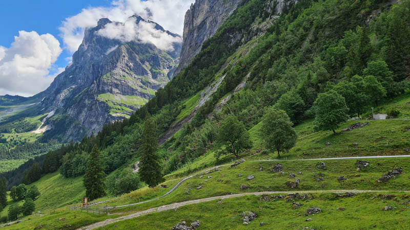
Above the cable car station, follow signs to Bäregg, walking west.

We stopped briefly at these benches to adjust our equipment and enjoy the view of Grindelwald.

The trail starts in the forest then under the cliff walls.

At the fork, stay left following signs to Bäregg. On your way back, you can optionally hike down the mountain by taking this fork.

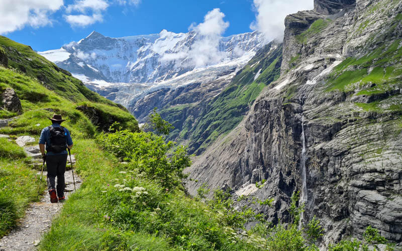
We walked by and through a few waterfalls and got a bit wet. Lots of stairs – it’s all uphill.

Was happy to have my hiking sticks on this trail.
Absolutely epic views!!!
There are several sections with steep drop-offs. Some of them have railings and fences.
Looking back on one section that had the steepest drop-off.

Happy to have a fence here.

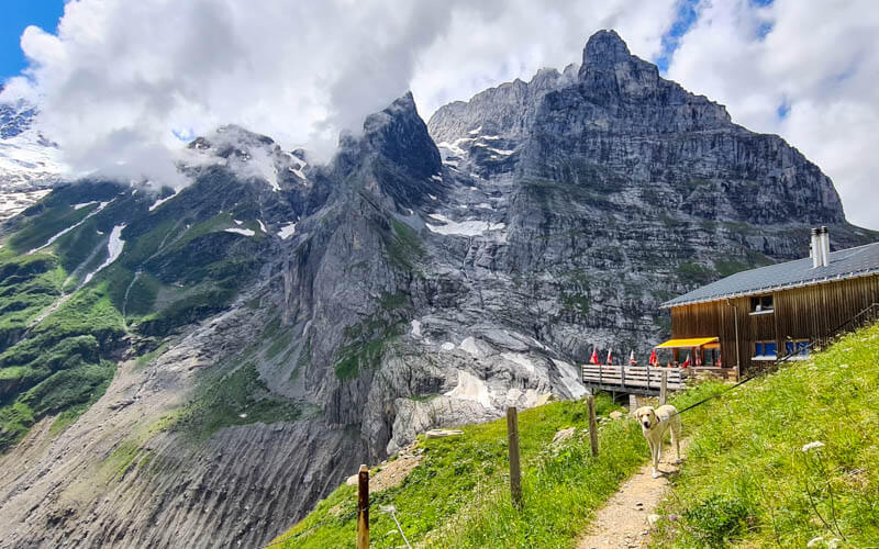
That flag up there is the hut. You’re almost there.z

At the Bäregg hut
After about 90 mins you’ll reach the Bäregg hut. It’s a short hike.
Grab a table and have some refreshments. They have a toilet here (CHF 2 if you aren’t a customer).
The menu is typical hut food with sausage, rösti, soup, etc. They take cash or card.

What a fantastic setting for this hut.
The trail continues past the Bäregg hut to another hut, but it’s a dangerous blue/white trail, only for expert hikers willing to take risks. I didn’t hike on it, so I don’t know what it’s like.

Hiking back down the way we came.
We hiked back to the Pfingstegg cable car and rode down, which I recommend. I’ve done the hike all the way down to Grindelwald and it’s mostly in the forest, not that special.
If you hike back to the cable car, then you can do the summer toboggan and “fly line” ride as a reward for good hiking.


4 responses
Thank for amazing blog (I am also a big fan of the youtube chanel.. 🙂
we are couple plus 10 yo child staying in Griendelwald in July:
what will be the best and second walking from:
1. eigergletcher to alpinglen (and maybe walk to griendenwald)?
2. eigergletcher to k.s and then to Wengen?
3. the hike up from pfingstegg to baregg?
thanks !
Hi. I probably wouldn’t do the baregg hike with a 10 yr old. I saw several kids on that trail but the steep offs just make me nervous when hiking with kids. So up to you. The other two are both nice. I might choose the one to Wengen first, since I like that view to the Lauterbrunnen valley a bit more. But the Eiger trail to Alpinglen is also very beautiful and you get the Eiger right above you. I don’t think you can go wrong.
This is such a wonderful hike indeed! We actually did the blue/white trail to the Schreckhorn hut (not with children, of course). It has lots of via-ferrata style sections with chains, ladders, vertical climbing, but it was doable without equipment, quite fun for adults who have no problem with vertigo 🙂 one of the most beautiful hut hikes I’ve ever done in Switzerland, on a relative accessible blue/white trail. And the hut warden welcomed us with snacks and Schnapps 🙂
Thanks for the report about the blue/white trail. That confirms I definitely don’t want to do it. But maybe someone else reading this trail might want to. So super helpful.