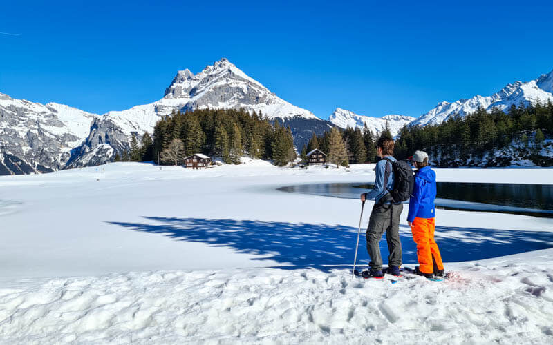
This short snowshoe trail near Lucerne delivers big on the mountain views. After riding up a little cable car, it’s a loop trail, crossing the ski slope then heading to a more quiet area near the frozen alpine lake, usually covered in snow.
Part of the trail traverses a steep slope and the path is slanted, making it a bit difficult to walk. But the second half of the trail is so beautiful that I forgive that first part. Keep reading for all the details to plan your winter hike.
Please check snow conditions before heading out. If avalanche warnings are high, this trail may be closed.
| Location: | Canton Nidwalden – Lake Lucerne Region |
| Address: | Fell-Chrüzhütte cable car, Dorfstrasse, 6387 Wolfenschiessen |
| Car: | Parking: 46°52’55.0″N 8°25’17.0″E 35 mins from Luzern, 1hr5 from Zurich |
| Transit: | Wolfenschiessen, Bahnhof, then bus to Oberrickenbach, Talstation 45 mins from Luzern, 1hr45 from Zürich |
| Trail: | 3 km loop, about 90 mins |
| Elevation: | highest point 1700m |
| Condition: | marked trail, snow not groomed |
| Skill: | moderate, 110m up/down |
| Open: | Dec through March, assuming snow |
| Services: | Kiosk near cable car, hotel restaurant along trail (open weekends and holidays) |
| Prices 2023: | Return cable car fare: Adult CHF 23, Child CHF 11.50, Family CHF 49 |
| More info: | www.bannalp.ch • webcam • forecast |
Location
This snowshoe trail is in Bannalp, a small mountain area in central Switzerland, southwest of Luzern.
Here’s the Bannalp winter map.

Trail map
The trail starts at the top of the Fell-Chrüzhütte cable car. It’s a short loop trail near the ski hills. It’s not super difficult but there is a bit of steep uphill climb at the end. At the far west end of the loop, the trail splits and you can take a shortcut up or continue to the hotel straight ahead (which is closed in winter) and loop around it, climbing back up the hill. The tour is so short that we opted for adding this extra bit. The snowshoe route may not exactly match my trail map below. Just follow the pink poles and signs.
See trail map on Komoot • SchweizMobil • OutdoorActive
See also How to snowshoe in Switzerland for beginners
Getting there
The cable car is in a small alpine village Fellboden accessed by a winding mountain road.
By car: Drive to Wolfschiessen then turn up the mountain toward Bannalp. Almost at the end of the road, you’ll see the Fell cable car on our left. There is some parking next this cable car. If that’s full, keep driving down the road there is another small lot next to the bus stop. There is another cable car on our right, but that doesn’t run in winter.
By public transport: Take a train to Wolfenschiessen, Bahnhof, then bus to Oberrickenbach, Talstation, which drops off near the Fell cable car. This bus runs infrequently, so check the schedule before you go out. On weekends, it runs about every hour except over lunchtime.
Gondola tickets & operating times
In the 2023/24 season, a return ticket on the Fell-Chrüzhütte cable car costs CHF 23/adult and CHF 11.50/child aged 6-16. No discounts for travel cards.
It’s a small cable car, fitting about 15 people (reduced to 10 during pandemic restrictions). It runs every 30 mins from 8:30 to 16:30, or continually on busy days. They take a break for lunch between 12:00-13:00. Check the Bannalp website for current prices and operating times.
What to bring and wear
You can rent snowshoes and poles at the cable car for CHF 10. You should wear waterproof hiking shoes, to which the snowshoes will attach. You should wear warm layers appropriate to the weather forecast and waterproof outer layers to stay dry in the snow.
See also What to pack & wear on a winter hike
Where to eat
The Bannalp ski resort has a kiosk at the lift just above the cable car. They seem to be selling sausages and other quick food. You could stop here after your snowshoe hike. The Urnenstaffel hotel has a restaurant but you get there after only 30 mins hiking, so probably not the best choice. It’s only open on weekends, school holidays 11:00-15:00 and Wed afternoons 13.15 – 16.00.
Photo story of the trail
Note: We did this trail during the week in Feb 2021 when sand particles from the Sahara turned the skies orange. So it will look different when you go.
Riding up the Fell-Chrüzhütte cable car
The cable car normally fits 15 people, but during the pandemic, the capacity was reduced to 10. During ski season, it runs continually

Here’s your first view when you get off the cable car.

The snowshoe trails starts by passing these huts.

Just follow the pink poles, starting below the ski hills.

As you traverse the slope, the trail is very slanted, which made it hard to walk on, with one foot higher than the other.

You are headed down to that big building in the distance. It’s a hotel and restaurant.

This part crosses the ski slope, so beware of skiers above you and move quickly across. The slope was so slanted that we kept falling over and tripping. I don’t know if it’s always that way. But we found it quite difficult.

Arriving at Berggasthaus Urnerstaffel. It took us about 30 mins to get here.

Loop around towards lake
Now the trail turns around and we loop back towards the lake.

This first section was also very slanted, traversing the slope. I accidentally dropped my phone and it slid about 100m down the hill before I could catch it.

A bit through the forest.

Big mountain views on this section, the best part of the trail.

Feels really epic over here. And it would be even better on a sunny day.

Shortcut
When you see the church, there’s a shortcut up the hill, not super well-marked. But we just continued straight on the snowshoe path, only a few minutes more.

Reaching Berggasthaus Bannalpsee. It’s not open during winter. The snowshoe path loops around that building then back up the hill.

This sign is showing the shortcut by the church that I mentioned before.

Uphill to the end of the hike
A short but tough climb uphill.

The trail passes through the trees, still uphill but not quite as steep. The other pic is looking back down at our trail.

Almost back to the cable car station, that building on the left.

Last look before we head home. The full trail took us about 1hr45.