The Staubbach Falls is perhaps the most famous of the 72 waterfalls in Lauterbrunnen valley. The third tallest waterfall at 297m, the Staubbach Falls are easy to visit, just a short walk from the train station or parking, no gondola or long hike required. You can optionally hike up a short dirt path to a closer viewpoint, then through a tunnel to a lookout behind the water.
Here’s how to visit the Staubbach falls and tips for your visit.
| Location: | Lauterbrunnen / Bernese Oberland, Switzerland |
| Car: | Parking GPS: 46°35’31.2″N 7°54’27.9″E 15 mins from Interlaken, 1hr50 from Zürich |
| Train: | Lauterbrunnen, Bahnhof train station 24 mins from Interlaken, 2hr30 from Zürich |
| Trail: | 10 min walk from train station to falls |
| Condition: | paved path to falls, ok for strollers |
| Skill: | easy |
| Open: | best April to October, but possible to visit year round |
| Cost: | free |
| More info: | • webcam • forecast |
Area overview
The Staubbach falls are located on the south end of the Lauterbrunnen village. It’s about a 5 min walk from the Lauterbrunnen train station. The falls are adjacent to the parking.

You can easily see the falls from the road and get many good pictures from there. Many classic photos of the Staubbach falls are taken from the Lauterbrunnen village, not super close to the falls. See one popular viewpoint on Google Maps.
You can optionally hike up a short path to get closer to the falls. The path leads through a tunnel and up stairs to a lookout behind the water.
Walking map
The following map shows how to reach the falls from the Lauterbrunnen train station. It also includes the optional path from the base of the falls to a closer viewpoint. This path has stairs and is slippery with wet ground.
See an interactive version of this map on Komoot.
Accessibility
The path leading to the base of the falls is on a paved route, suitable for strollers and wheelchairs. The optional path up the falls is a narrow dirt footpath with stairs, not obstacle-free.
How to get to Lauterbrunnen
The Staubbach falls are location in Lauterbrunnen Switzerland, south of Interlaken (see on Google Maps).

You can easily reach the falls by car or public transportation, no gondola required. The closest address to the falls is Pfrundmatte 419, 3822 Lauterbrunnen.
By public transport:
Take a train to the Lauterbrunnen station. Walk along the main road south through the village as shown on the hiking map above. It’s about a 10 mins walk to the base of the falls.
By car:
Drive to Lauterbrunnen and park in the metered lot next to the church – 46°35’31.7″N 7°54’28.4″E. If that lot is full, you may be able to park in the Lauterbrunnen parking garage behind the train station – Gütli 481, 3812 Wilderswil
The path starts on the private road next to the parking leading south into the valley.
Planning your day
This is a short activity, so best to combine this with other activities in the area. You can visit the Staubbach falls at the start of an easy 2 hour walk down the Lauterbrunnen valley. Or perhaps visit it before riding up the Lauterbrunnen cable car to do the Mürren Mountain View trail. Since it doesn’t have opening or closing times, you can easily do this early in the morning or late afternoon.
When to visit
Although you can visit this area any time of year, the waterfalls are probably best from April to September when the snow is melting. Outside this time, the water flow may be reduced.
What to wear and bring
Check the Lauterbrunnen weather forecast and dress appropriately for the weather. If you hike up closer to the falls, you may want a rain jacket to stay dry.
The walk to the falls is paved and suitable for any footwear. For the path to the lookout behind the falls, we suggest walking shoes with good tread as the path is very wet and slippery from the waterfall spray.
The falls are very close to the village, so you don’t necessarily need to bring water or food on this outing.
Where to eat
There are several restaurants in the Lauterbrunnen village, a short distance from the Staubbach falls. Most of them are hotels with full-service restaurants serving traditional Swiss food. For a less expensive meal, try Food Point Kebap or Base Café.
There is a Coop grocery across from the train station (see on map). There are also a couple bakeries in town that have pre-made sandwiches.
Photo story
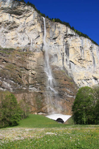
This picture was taken from the popular photospot just below the main street – see on map.

You can see the falls as you walk through the village. This picture was taken in mid-November.

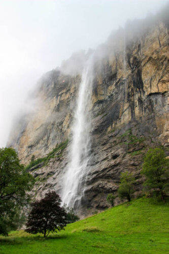
The first picture below was taken in mid June, when there was still a snow pack at the base of the falls. The second picture was taking in early July.

You have a very nice view of the falls just from the road.

For a closer look, follow the dirt path up the stairs as shown here.


This picture shows the path winding up the hill to a closer viewpoint.

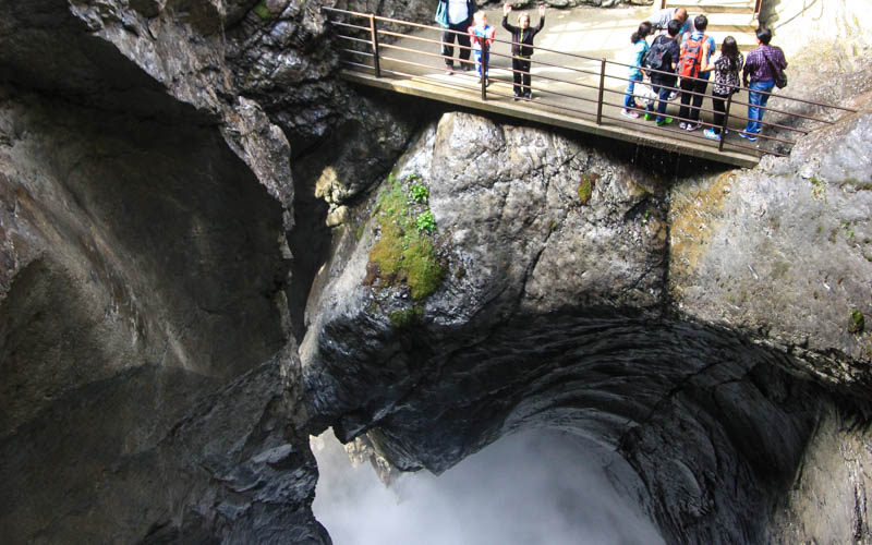
To reach the lookout behind the falls, you walk through this tunnel.

Then some stairs to the lookout behind the falls. It’s very wet here.

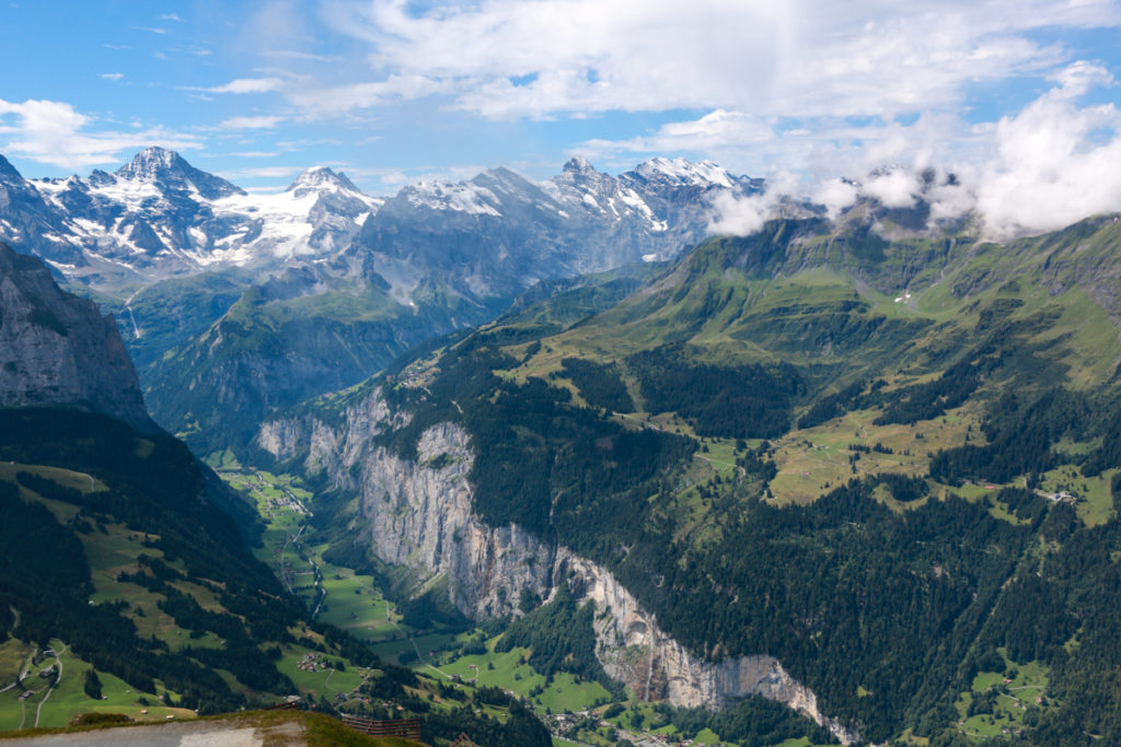
If you are riding the Grütschalp cable car, make sure to stand near the door you enter so you get this view on your way up.

You can also see Staubbach Falls from the bus ride down Lauterbrunnen valley.

Make sure to also visit Trümmelbach Falls while you are in Lauterbrunnen.


4 responses
Awesome hike, but be careful routing to the pin in the post. Google Maps took us to the road next to the parking lot and then there were so many cars and people around that we couldn’t turn around and ended up on a forbidden road. Routing directly to the Kirche Parking lot worked though.
Thanks for the feedback. I will update the post to be more clear about where to park. You cannot drive directly to the Staubbach falls. Instead park at the Kirche parking and walk over.
Loved your posts. We are 4 senior adults looking for some easy waterfalls in April of 24. Will be making our way via trains from Italy to Netherlands. Would love your advice on must see areas as we go through. Thanks so much
Hi. I’d suggest Seerenbach falls (on the Walensee) and Giessbach falls on Lake Brienz, both which are easy to access during the time you are here. Just search those names on my site to get the info. You might also like my waterfalls post: https://swissfamilyfun.com/best-waterfalls-in-switzerland/