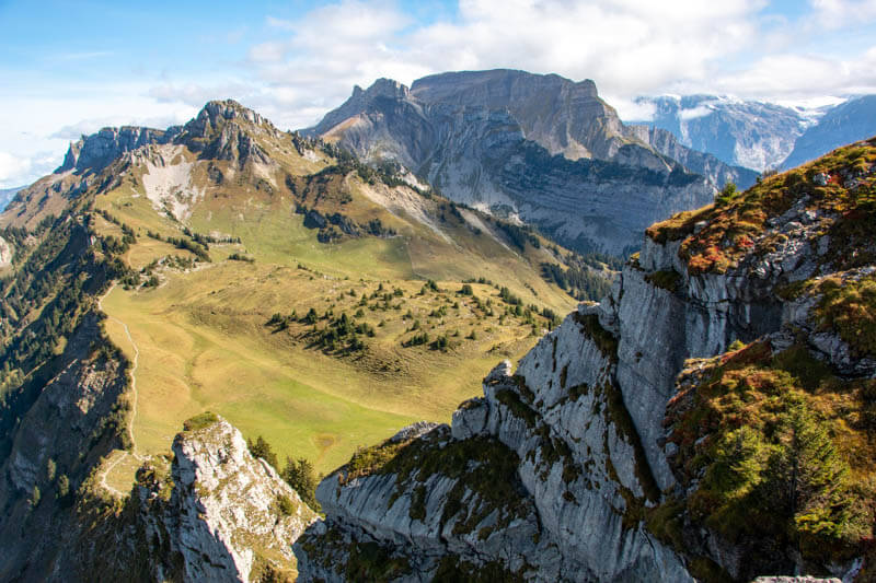
This ridge trail is utterly charming, with big mountain views, rocky peaks, dramatic cliffs, and lush meadows filled with wildflowers. It’s not as popular as other hikes in the Jungfrau region, so you’re likely to avoid the big crowds you see elsewhere like on the Jungfraujoch train.
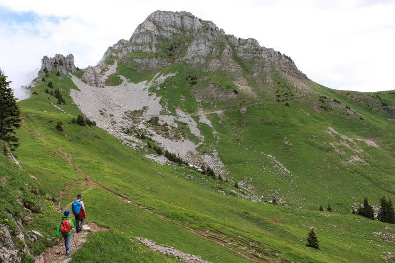
It’s a dirt alpine trail, not suitable for strollers, but the hike is easy going, with only one short uphill trek to the ridge. Children will need a little endurance, but I think a six year old with hiking experience can manage it.
There are plenty of places to picnic with a view, but only one official fire pit near the start of the hike. Near the train station, there’s a restaurant with large panorama terrace and a little playground with swings, see-saw and tiny barefoot path. This is a great option for both locals and visitors of all ages.
Contents
Quick info
| Region: | Jungfrau Region • Bernese Oberland Switzerland |
| Address: | Wilderswil train station – |
| By car: | Parking at Alte Staatsstrasse, 3812 Wilderswil From Interlaken 5 mins, Bern 45 mins, Zurich 1hr30 |
| By train: | Train station: Wilderswil, Bahnhof From Interlaken 3 mins, Bern 1hr10, Zurich 2hr10 |
| Trail: | 2 hours |
| Distance: | 6.2 km there & back • trail map ⬇️ |
| Difficulty: | moderate • 120m up & down |
| Path Type: | narrow dirt path with uneven terrain and stairs |
| Elevation: | highest point 2076m |
| Open: | July to October |
| Cost (2025): | Mountain train round trip – CHF 71.60/adult |
| Discounts: | Free with Jungfrau Travel Pass & Bernese Oberland Pass Discount 50% with Swiss Travel Pass and Half Fare Card |
| Services: | restaurants, playground, activity trail for kids |
| More info: | www.jungfrau.ch • webcam • weather |
Gallery


Trail overview
This is a loop trail starting at the top of the Schynige Platte railway. Here is the panorama map showing all the trails from the top of Schynige Platte.
Hiking map
The trail starts just above the Schynige Platte train station. Follow signs to the Alpinegarten, then to Daube, climbing some switchbacks to the viewpoint over the cliffs.
Then follow the ridge in direction Faulhorn. After about 1hr15, you will loop back towards Schynige Platte, following a lower trail through meadows.

View interactive map, print map and download GPX on Komoot • SchweizMobil • OutdoorActive
The trail is a dirt alpine trail, not suitable for strollers, sometimes rocky with a few switchbacks, with a little up and down, but no huge elevation gains. I’d recommend this for children 6+ with hiking experience. I recommend bringing walking sticks.
Shorter version:
You can do a shorter 3km loop, which still has big views and follows the ridge for part of the trail. See trail map.
How to get there
Schynige Platte is a mountain just south of Interlaken in the Jungfrau Region.

It is accessed with a cogwheel mountain train from the Wilderswil train station. See on Google Maps.
By car:
There is a large “Park+Ride” lot a short walk north of the Wilderswil train station at Alte Staatsstrasse, 3812 Wilderswil (see available spots). Overflow parking at nearby Matten bei Interlaken train station.
By transit:
Take a train to Wilderswil. From Interlaken Ost 5 mins, Lauterbrunnen 15 mins, Grindelwald 30 mins. At the Wilderswil train station, switch to the vintage cogwheel train.
Planning your day
Ticket prices
You’ll need a return ticket for the mountain train from Wilderswil to Schynige Platte. You don’t need to buy in advance. Boarding is first come, first served.
In 2025, this return ticket costs CHF 71.60/adult. See website for current prices and offers.
Children: Discount 50% for age 6-15, free under 6. Free for children with SBB Junior Card or Swiss Family Card.
Free with Jungfrau Travel Pass and Berner Oberland Regional Pass.
Discount 50% for Swiss Travel Pass, Half Fare Card, and GA.
Operating times
The Schynige Platte cogwheel train runs from July to mid October.
The train leaves from Wilderswil every 40 minutes from 07:52 to 16:45. The train ride lasts 52 minutes. The train returns from Schynige Platte every 40 minutes from about 8:21 to 17:53.
Check the schedule on SBB.ch to verify the times on the day you go.
Food & Services
There is a restaurant and other services at the start near the train station. There is a picnic area with a fire pit and wood just below the Schynige Platte train station, but no place to grill along the trail. So better to bring a picnic if you want to eat along the way.
Photo story of the trail
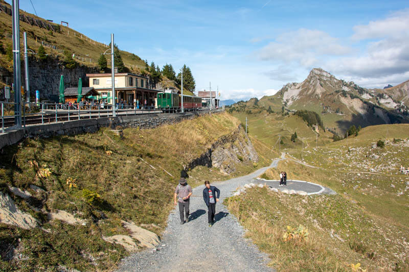
1. Boarding mountain train at Wilderswil
Here is the train station in Wilderswil. You can sit in any cabin unless it is labeled “reserved”. The train operators will come by to check your ticket, then lock your door from the outside. Both sides of the train are nice, but the right side has better views at the top.

2. Arriving at mountain top
After about 50 minutes slowly climbing the mountain with lots of great views, you arrive here. There are free toilets here and a kiosk for snacks.
We were greeted by alphorns. The Panoramaweg is not on the initial trail signs. So instead, follow signs to Daube, which is the first viewpoint on the Panoramaweg.

Walk on the paved path north to the restaurant. The hike starts just beyond the restaurant.

The panorama terrace for the self-service café. I noticed that they had high-chairs.

3. Starting the trail
Start the trail just above the mountain train station, walking through the alpine garden.

When you reach these bells, follow the trail to your left that traverses the mountain, following signs to Daube.

Follow the trail here that leads to the peak ahead, called Daube.

Going up the switchbacks with my son and dad.

The clouds happily parted briefly to give us this beautiful view. A little treat as we climb.
A few minutes of switchbacks.

4. Arriving at Daube viewpoint
The end of the short hard uphill bit, ending at the Daube viewpoint.

You can look over the cliffs near the metal fence to see Interlaken and the lakes.

Great place to take a little snack break. Soon we’ll be hiking on the ridge you see below.
Picnic time.

5. Continue ridge to Oberberghorn
Now joining the trail heading east along the ridge. A nicely maintained path with some stairs.
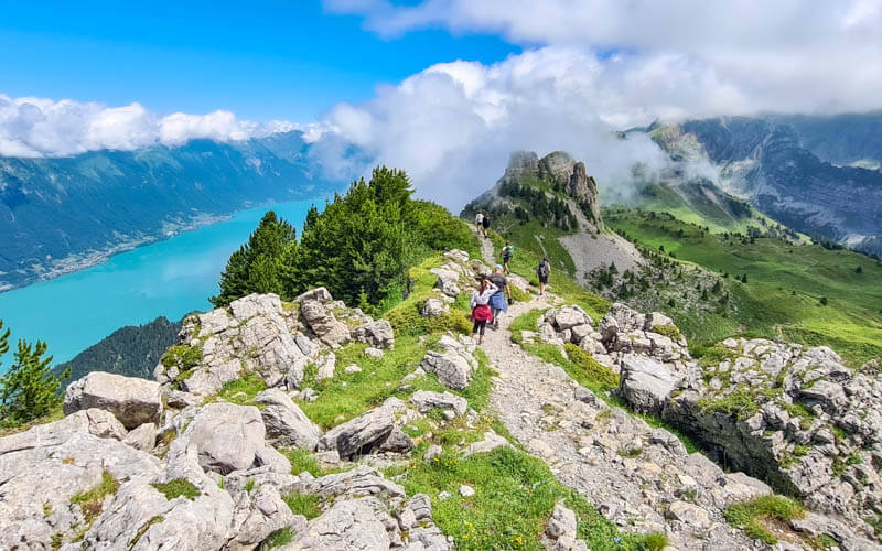
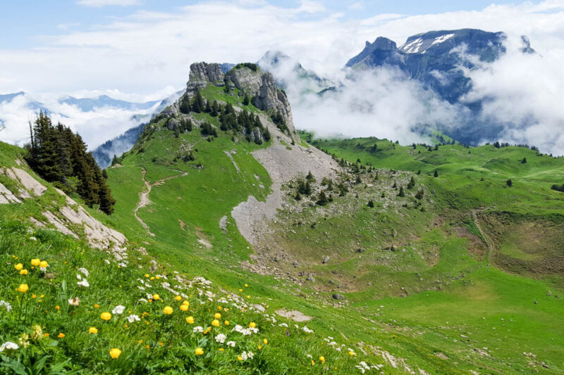
Cliffs dropping down to the Brienzersee on the left. Coming up is Oberberghorn, those pinnacles straight ahead.

The path is well set back from the cliffs, but keep little wild ones on a short leash.

6. Detour to Oberberghorn viewpoint
Just below those pinnacles, there is a short detour (go left at this sign) up to the Oberberghorn viewpoint. I think this detour is totally worth it.
Yes, the views are similar, but you get a bird’s eye view of the trail from up there. After the detour, retrace your steps back to this sign and continue walking straight ahead on the main trail around the base of those pinnacles.

After a couple switchbacks on the detour trail, some steep stairs to get to the top of Oberberghorn. Be careful and go slow, especially if they are wet.

The fenced in viewpoint at the top of Oberberghorn.

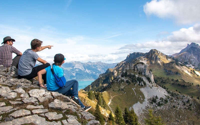
Looking back at the ridge trail and down to Interlaken and Thunersee lake.

View east from Oberberghorn, so spectacular.
7. Rejoin ridge trail
Now back on the main trail, walking east around the Oberberghorn above you.

Some of the nicest mountain views along this part.
Keep following the Panoramaweg signs toward Faulhorn even though you aren’t going all the way to that.

Looping back around to the ridge.

Back along the ridge after Oberberghorn. Now we can see the Brienzersee below.

Looking back toward Oberberghorn.

Yes, I am on this trail.

Looking back on the trail.

8. Loop back toward Schynige Platte
A few stairs, then you can see the fork ahead when the trail heads back to Schynige Platte.

We are going to turn around at that fork. If you keep going, you’ll be hiking to Faulhorn and First, a much longer hike (like another 4 hours!).
Heading back, through meadows instead of the ridge.

View toward the famous peaks, Eiger and Jungfrau.
There are a couple trails that split to the left and right. Just keep walking straight ahead, following signs to to Schynige Platte.

Nice place for family photos.

Almost done and looking back on the meadows we hiked through.

Here’s the picnic area just below the Schynige Platte train station. There is a box of wood next to the fire pit and grill. You don’t have a great view from the benches, but you can simply walk up this hill a bit to get the views again.

Ending the trail at the Schynige Platte train station. Remember that the train comes every 40 mins. So remember to check the schedule so you know if you need to hurry on this last bit or take your time. Last time we went in Sept 2019, the train came in the afternoon at 15:01, 15:41, 16:21, 17:01, and 17:30. Don’t miss the last train down!
Video of trail
Here is a short video of our Schynige Platte hike in late September 2019.
/vie
I hope you like it! Need more ideas for the Jungfrau Region?


50 responses
Great hike! Where do you find the actual weather to plan ahead as weather Apps tend to omit peaks? Google told me it would be cool 14 on Sunday, but it was blazing HOT and no water sources along the way made it quite dangerous for my dog.
I always use https://search.ch/meteo/ and https://www.meteoswiss.admin.ch/ for weather in Switzerland. They are much more accurate. The temp on the mountain isn’t always given. If it’s a sunny summer day, it can be very hot even at high elevations. For future summer hikes, I suggest always bringing a water dish for your dog so you can provide water from a bottle during the hike.
This is easily the best blog/youtube content for planning hikes and excursions in Switzerland. I followed some of your advice for a trip last year and am back again planning the hikes I missed last year! This is definitely on the list. Thanks!!
Hello
Can we buy train tickets up to Schynige plate at the station when we arrive?
Kind regards Emma
Yes, you can buy tickets at the ticket office next to the train station. But there may be a line, so go a bit early.
Hello,
Thank you for all the content. I will be in the area for a few days and was hoping you could shed some light on a few things. I was considering Augstmatthorn, Oeschinesee, Brienzer Rohorn and came across now the Schynige Platte Panorama trail. How would you decide between these? Furthermore, if I was planning on doing Schynige Platte to Faulhorn First trail, is the completely different than the panorama trail. Any insights would be greatly appreciated. Thank you!
The Schynige Platte to Faulhorn hike is great. You’ll do part of the Schynige Platte loop trail so no need to do both. Just pick the distance you want to do any choose one of those. I think Brienzer Rothorn is nicer than Augstmatthorn, which has a long ascent in the forest with no views until you reach the top. Oeschinensee panorama trail is very nice, but can be a bit crowded. Hope that helps.
Hello, I greatly appreciate your website. I plan to be in the area in late June 2023. Schynige Platte was my top choice for hiking. Unfortunately, I see that Schynige Platte will not be assessable due to construction until July 1st.
Is there another way to experience the Schynige Platte area by coming from another area that wouldn’t take all day? Or can you please provide some similar alternatives to Schynige Platte in the Jungfrau Region? Thank you
That’s unfortunate about the construction. You might enjoy the ridge trail at Niederhorn, which is also quite close to Interlaken: https://swissfamilyfun.com/niederhorn-ridge-hike/
Hey, thanks a lot for this post! I just came back from this hiking and it was absolutely beautiful.
Your page will be my number one reference for everything Switzerland related!
Thanks so much for coming back to leave this nice message. So glad you enjoyed the hike!
I am so thankful to have found your helpful site! Can you estimate how long you think it would take from Wilderswil to Schynige Platte – hike to Obergehorn and then back on the way to Wildersville train station? We are a family of five all experienced hikers /adults
Thank you!
I would suggest that you map your route on a mapping app so you know what to expect. I did a quick version and it looks like about a 7.5 km hike up from Wilderswil to Schynige Platte, about 4 hours, gaining about 1450m. Then probably 1.5 hr to Obergehorn. Then another 4 hours back down the mountain. I wouldn’t recommend this at all, unless you really need to save money on the mountain train tickets. There are much better hikes to do than spending a few hours trudging up a mountain in the forest. Better to skip to the good part and enjoy fab views during the whole hike.
Thank you for such a clear write-up! Used your guide during a recent journey, and I’m not sure we would have made it without you. Thank you!
Yay! So glad you found my guide helpful. It’s such a great hike, happy you got to do it.
Hello! Planning to do Schynige Platte trip this weekend with 3 years old and 6 months old 🙂 do you think that all-terrain stroller will fit in the train? Is there some stroller friendly path above? Doesn’t have to be long….
Thank you for great inspirations!
The stroller would not fit in the regular seated area. They might be able to loaded in their luggage section. But you cannot use the stroller on the trails there.
Hello! Are you able to hike to the restaurant from the parking lot, instead of taking the Wilderswil train? Thanks!
You can hike up the mountain from Wilderswil but it would take you a few hours.
Thank you for sharing! This hike looks beautiful. Would it be a bad idea to do this hike with rain in the forecast?
If you had light rain, it would probably be ok but not my first choice. Our first time we did this hike, we had a light drizzle for about half of the hike. With rain, I would choose a hike that has charms that aren’t disturbed by rain, like walking by a river or in a forest.
Thanks again for all your work documenting these amazing hikes. I did this one yesterday, but elected to keep going to First, which I highly recommend. Starting from Schynige Platte Station — without the Obergehorn peak detour — at 10 am I was at First by about 16:30 with a long picnic at Bachalpsee to wait for the clouds to clear. Also skipped Faulhorn peak due to the lack of visibility up there.
Hi Andy, so funny that you did this hike right before I did it. Great minds think alike!
Hi can you drive any higher than the train station? Is that only way up.
As far as I know, you cannot drive further up the mountain unless you have a special permit as a service vehicle or resident.
thank you very much! looks great! do you think it will be recommended for is? family with three, five and seven years old children…?
Hi, sorry for the late reply. I think a three year old would have a tough time finishing this hike and it could be dangerous. A five and seven year old with hiking experience would be fine as long as you watch them carefully when near the steep cliff edges.
Hallo!
Danke viel mals fuer diesen tollen Bericht! Das hat echt geholfen und wir werden diese schoene Route im July machen.
Super infos, klare anweisungen und hammer fotos.
Is there a shorter version of this hike? We are going end of May with a 5 year old and 3 year old. Thanks.
Hi Julie! Yes, you can definitely do a shorter version. I’ve mapped out a 3km loop that might work for you. https://www.komoot.com/tour/114851951?ref=wtd Of course, you could simply walk 1 km along the trail and turn around and walk back to make it even shorter.
Hi – Thank you for all the information. I am planning to do a 5-7 day trip in Jungfrau region. I would like to start in the morning, hike/transportation depending on the mood. My only problem is my luggage. Are there any same day luggage transfer services from door to door.
Where are you transferring your luggage? It’s probably easier to leave your luggage at your hotel and simply return each day to your starting point. But it depends on where you are going.
Hi there, What hiking trails do you recommend for hiking during April 9th -14th.
Thank You kindly
I’m working on a post for that, so look for that soon. Unfortunately, mountain trails will be closed then because it’s still ski season. But you could do some winter walks instead if they are still open. The winter walk from Grindelwald First to Bachalpsee would be a good choice if it’s open.
Hi,
Thank you for the information.
We want to go to this region with my family. We live in Lausanne and don’t have a car. We like to take Jungfrau train tickets from lausanne to Schynige Platte and then hike down to Interlaken. We don’t want a hard hiking. Is there a good path for that? Or any suggestion?
I haven’t hiked from Schynige Platte to Interlaken so unfortunately I can’t recommend a particular trail for that route. However, I would assume that hike would be quite difficult as it would descend about 1500m. I see that there is a hike from Schynige Platte to Breitlauenen, which is partway down the mountain train route back to Wilderswil. Here are the details. https://www.jungfrau.ch/shop/en/tickets/bergbahn/angebote/schynige-platte/wanderticket-breitlauenen-schynige-platte
I did this beautiful trail today, they added signes with the numbers and names of the different routes so it was easy to follow route 3.
I’m so glad to hear that! The signs were in a little disrepair last time I went. I hope I can do this trail again this summer. Glad you had a good time!
Hello, I just found your video ‘Top 5 Swiss Family hikes’, and loved it. We are going to that region for a week, we are a Family with a 5 years old with hiking expirience and a baby 9 months old with a Rücktrager. I want to ask you, if it is posible to do this 5 hikes for us and if there is a way where we kann go maybe uphill with the cableway and walking downhill. Thank you in advance.
Thanks! Which hike do you want to do? If it’s the Schynige Platte hike, you take the mountain train to the top, then do the hike, then ride the train back down. There isn’t more mountain transport at the top. Let me know which hike you were looking at and maybe I can give you more tips.
If we wanted to walk about 15 minutes out from the picnic tables or train station, and 15 mins back, which trail signs would you suggest that we follow where we would have the nicest views?
It just depends on what you want to see. If you go right, towards the restaurant and up the hill above the restaurant, you can see northwards toward the lakes. If you go left, you will see the Jungfrau region mountains. Both are very nice. I would probably hike a bit above the restaurant, then you can see both directions a bit. Hope you have a good time. Sorry for the lake reply.
hi. i’ll be in interlaken for four days. going to do this hike and other areas. what kind of rail pass would you recommend?
It’s best to compare the price of what you plan to do with the daily rail pass price. Some rail passes only make sense if you are visiting more than one mountain in the same day and traveling there and back using public transportation. If you are hiking in the Jungfrau region and are traveling by public transportation, the Jungfrau Travel Pass probably makes the most sense. You might find this website helpful in comparing Swiss rail passes. https://www.myswissalps.com/train/ticketspasses
Hi guys, thanks for your excellent reports. Full of great detail. I’m not a Mom with Tots but a Dad with two sons in their twenties! We’re off to Lauterbrunnen for 4 days at end of June 18 and will be doing many of the walks in this area. I’ve worked out the costs and as we don’t want to be walking hours uphill – will be buying the Jungfrau 3 day rail pass. It looks great value even if you want to go up and down a cable-car twice on each mountain! Yippee, Why not…..this is Mother Natures playground and cannot wait. Thankyou so much for sharing these.
Glad I could help! I should really change our name to be more inclusive. Our YouTube channel is called Swiss Family Fun and maybe I’ll get around to moving that name over here. In any case, wishing you a great time and good weather in the Jungfrau Region.
Thank you very much for sharing all your ideas. Even if I’m Swiss I love finding great inspiration here… do you think this hike is possible for someone who is afraid of heights? (How long is the steep part ?). Thanks a lot for all 😀
Nb your pictures are great 👍
Thanks for the kind words! If you are afraid of heights, you might feel a bit queasy on the sections that have steep drop offs to one side. But you don’t have to walk close to the edge and the other side is not a steep drop off. I only felt nervous when I walked up to the edge and looked over on purpose. If you stick to the trail, it’s not particularly dangerous. But I certainly can’t speak for everyone. I’m curious to hear if you like it.
Great post! thanks for sharing.