Starting at the San Salvatore viewpoint over Lake Lugano, this quiet trail wanders across the mountain to Morcote, considered one of the most beautiful villages in Switzerland.
Much of the hike is forested with occasional lake views, providing welcome relief from the summer heat. You’ll pass through a couple cute villages and a nature park, filled with azaleas and other flowering bushes in spring.
Near the end, you’ll descend a seemingly endless amount of stairs, a wonder of good trail maintenance (but not ideal for bad knees).
Finally a short wander through the narrow lanes of Morcote, visiting the chapel and swing overlooking the water. Grab gelato for your reward, then a relaxing afternoon lake cruise back to Lugano.
Keep reading for all the info you need for a successful outing.
Quick Info
| Region | Lugano Region, Ticino Switzerland |
| Start: | San Salvatore funicular – Via delle Scuole 7, 6900 Paradiso |
| End | Morcote village |
| By car: | Metered parking at San Salvatore funicular From Lugano 8 mins, Bellinzona 40 mins, Locarno 45 mins, Zürich 2h30 |
| By public transport: | Paradiso train station or Paradiso, Stazione bus stop or Paradiso ferry stop From Lugano 6 mins, Bellinzona 27 mins, Locarno 36 mins, Zürich 2h10 |
| Trail: | 3h • ⬇️ trail map |
| Distance: | 9.3 km one way |
| Difficulty: | moderate +245m -855m |
| Condition: | footpath uneven rocky terrain and stairs |
| Elevation: | highest point 884m |
| Open: | April to October • trail status |
| Cost 2026: | one way funicular ticket CHF 25 + boat or public transport back to Lugano |
| Discounts: | 50% off with Swiss Travel Pass & Half Fare Card 25% off with Ticino Ticket |
| Services: | restaurants at both ends of trail, no services on trail |
| More info: | www.montesansalvatore.ch • webcam • Lugano forecast |
Gallery
These pics are from our hike on the first weekend in June.
Trail Overview
Here’s the summer hiking map for the San Salvatore area.


Hiking map
Our trail map below shows the trail starting at the top of the San Salvatore funicular train. The trail ends at the lakeside village Morcote. You could also hike this in reverse.

See map on SchweizMobil • Komoot • OutdoorActive
Trail conditions
The trail is a well-maintained hiking path. The terrain varies between uneven rocky terrain, gravel paths, and a few sections on paved roads.
There are many stairs at the end, descending the mountain to the lakeside at Morcote. This trail is not a good option if you have knee issues.
The trail is not dangerous. Suitable for any casual hiker, including children.
Shorter options
To shorten the trail, you can do a short hike down from San Salvatore. There are two bus stops in the Carona village you pass through on the hike.
- Carona, Ciona – 35 mins on the trail
- Carona, Paese – 1h on the trail
You could also park in Carona and hike to San Salvatore, then hike back the same way.
Longer version
Instead of riding up the funicular, you could hike from Lugano to the San Salvatore viewpoint, adding 3km and about 600m elevation gain. See this longer trail map.
Also, this trail is part of the long-distance Sentiero Lago di Lugano around the region. You could plan a multi-day hike, including this as part of the itinerary.
How to get there
This trail is located near Lugano, in the Ticino region of southern Switzerland.

It’s a one-way trail, with public transport connecting the ends of the hike. Our instructions have you start by riding the funicular train from Lugano Paradiso to San Salvatore.
The trail ends in Morcote, where you can travel back to Lugano by boat or bus+train.
IMPORTANT: Note the closing times of the mountain transport so you don’t miss the last ride down the mountain.
By public transport:
Take a train to Lugano Paradiso, then a 5 min walk to the San Salvatore funicular station.
If you are in the Lugano old town:
- walk about 25 mins along the lakeside promenade to the funicular station
- short bus ride to the Paradiso, Stazion/Scuole stop and 2 min walk to the funicular
- boat to Paradiso, then 6 min walk to funicular station
When you end the hike at Morcote, we suggest the boat back to Lugano. Check boat schedule. Note that the boat is not included with the Ticino Ticket.
Or you can take a bus and/or train. Check connections.
By car:
There is metered parking at the San Salvatore funicular station – Via delle Scuole 7, 6900 Paradiso. If this parking is full, you could park at the nearby Mantegazza parking garage – Via Generale Guisan 2, 6900 Paradiso.
When you end the hike at Morcote, you can take a bus and/or train back to Paradiso. Check connections. Or ride the boat to Paradiso and short walk to the parking.
Boat Morcote to Lugano
When you end the trail in Morcote, you can ride a boat back to Lugano. It takes about an hour and is a lovely ride. Check boat schedule.
You’ll need a one-way boat ticket. In 2026, this cost CHF 27.60/adult.
Free with Swiss Travel Pass, SBB Saver Day Pass, and GA. Discount 50% with Swiss Half Fare Card. No discount with Ticino Ticket, unless you get a day ticket for the boat.
You can purchase tickets on the SBB app (also with the EasyRide feature) and on the boat.
Planning your day
When to go
This trail is usually open from May through October. Check trail status.
The San Salvatore funicular runs year round. Check operating times.
Costs
You’ll need a one-way ticket on the San Salvatore funicular. In 2026, this costs CHF 25/adult.
When you end the hike in Morcote, you can return to Lugano via bus+train or boat. You can buy tickets for those on the SBB app.
Discounts
Discount 50% on funicular with Swiss Travel Pass and Half Fare Card.
The boat is free with Swiss Travel Pass, Saver Day Pass, and GA.
With Ticino Ticket, 20% off the funicular and free train+bus back to Lugano. No discount on boat.
You can sometimes get a SBB Railaway combo offer, with a discount on the train here and hiking ticket.
Where to eat
Ristorante Vetta San Salvatore is at the top of funicular. They have a large outdoor terrace and indoor seating next to big panorama windows. Their menu has a nice variety of traditional Ticinese and Swiss dishes.


At the end of the hike in Morcote, there are several restaurants along the lakeside. We might suggest Ristorante Barcaioli or Osteria la Terrazza sul Lago.
Where to stay
For this hike, we would stay in Lugano, where you have a cute old town and plenty of restaurants and other services.
For convenience, Hotel Federale is a great choice, just a couple minutes walk from the Lugano train station and old town center.
Their rooms have comfortable beds and air conditioning. Their restaurant has a peaceful terrace, a nice place to breakfast before the hike. For families, they have rooms with three twins and quad rooms with a sofa bed.


If you prefer to stay lakeside, we would choose International au Lac or for a luxury splurge, Hotel Splendide Royal.
For a budget stay, try ibis budget Lugano Paradiso or Lugano Savosa Youth Hotel (slightly outside the city).
Photo story of trail
Our photos are from early June.
Riding up the funicular
This is the entrance to the San Salvatore funicular station. You can buy tickets here.

If you want to take photos and videos of the ride up, best to stand in the lowest car.


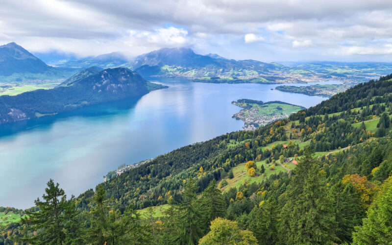
From the top of the funicular, it’s a 5 min walk up this viewpoint over Lake Lugano.

As you looking south, you can see our trail, wandering through the villages on the hill on the right.

Lunch
Before the hike, we had lunch at the restaurant near the funicular.

They have a big outdoor terrace. But if the weather is chilly, they have indoor seating with large panorama windows.

They serve classic Swiss dishes and regional specialties. Not fancy, but tasty and good value for Switzerland.
Starting the trail
From just outside the restaurant, follow trail signs for Route 52: Sentiero Lago di Lugano, direction Morcote.


We started with a little cloud cover.

Lots of forested section, great for a hot day. The Swiss flag markers are for Route 2: Trans Swiss Trail that passes through this same area.


Passing through this cute village, full of flowers.


Back into the forest


The trail cuts through Parco San Grato (free admission), full of azaleas flowering around the end of May.

There is a free public toilet at this building in the park.

Looking back at the San Salvatore peak.

Nice section through some grassy meadows.


Now a long stretch down hundreds of stairsteps, thankfully well built.


Along the way, a few breaks through the trees to catch lake views.

Ending in Morcote
The trail delivers you to the hills of Morcote, starting with a view of this much-photographed church tower and “Swing the World” swing. You can spend some time visiting the church and surrounding gardens.


Looking down to the Morcote village.

Wandering the narrow alleyways of Morcote, happily empty.


Stopping for La casa del gelato for cool treats. I had limon & sour cherry.


This “Grand Tour” sign is near the ferry dock. It swivels so you can take a pic of the lake and of the village.


You can catch the bus here. Check schedule.

Boat back to Lugano
We caught the last boat from Morcote at 18:05 (check schedule). Travel time about 1 hour to Lugano. We bought tickets on the SBB mobile app before boarding. Boat is free with Swiss Travel Pass, Saver Day Pass, and GA.


Gorgeous light in the evening.

The boat stopped in a few attractive villages along the way.


Such nice mountain views on the ride.

This boat ride was such a nice end to a great day! Hope you enjoy this hike.
See more of our favorite hikes near Lugano.