The “Schnitzlerweg Axalp” is an easy hike leading to a beautiful alpine lake surrounded by mountains, a lovely place for a picnic and refreshing swim.
Along the trail, you’ll pass more than 100 wooden sculptures carved by locals, a project started after big storms and avalanches in 1998/99 caused many trees to fall.
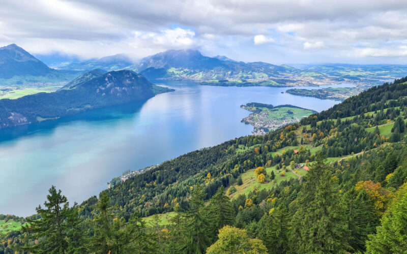
You walk through forest and fields, climbing high on the alp to admire panorama views down to Lake Brienz.
Keep reading for all the details you need to plan your outing.
Quick Info
| Region | Brienz region near Interlaken, Bernese Oberland Switzerland |
| Start: | Axalp village |
| By car: | Parking near Axalp Sportbahnen From Interlaken 35 mins, Luzern 1h15, Zürich 1h45 |
| By public transport: | Bus stop Axalp, Sportbahnen From Interlaken 1h, Luzern 2h, Zürich 3h |
| Trail: | 2h • ⬇️ trail map |
| Distance: | 6.1 km loop |
| Difficulty: | moderate +375m -387m easier version below |
| Condition: | dirt footpath, uneven rocky terrain |
| Elevation: | highest point 1723m |
| Open: | June to October |
| Cost: | parking fees or bus fare to reach trail head |
| Discounts: | bus to trail included with Swiss Travel Pass, Saver Day Pass, GA, and Bernese Oberland Pass |
| Services: | restaurant at start of trail and on trail picnic areas with fire pits at lake |
| More info: | www.axalp.ch • webcam • Axalp forecast |
Gallery
These pics are from our hike the first week of July.
Trail Overview
This trail starts in the Axalp village, directly from the parking and bus stop next to the chair lift (A).

It hikes out to the lake (B) in about an hour. For an easier day, just hike back the same way.
But we prefer staying on the official trail, looping back on the higher trail, which gives you bigger views. There is a short detour to a mountain cafe (C). Then descend to link back to the original trail, leading you to Axalp.
See map on SchweizMobil • Komoot • OutdoorActive
Trail conditions
The trail is a typical mountain hiking path. The terrain varies between uneven rocky terrain and gravel paths.
We suggest hiking sticks to help with balance on steeper sections with loose rocks and gravel.
No dangerous or exposed sections. Suitable for any casual hiker, including children.
Shorter option
For a bit shorter, a bit easier day, you can hike to the lake and back the same way. In this case, the trail is 5.2 km, 350m up & down.
How to get there
This trail is located in Axalp, a small mountain village near Brienz, east of Interlaken.

It does not require mountain transport. You start the trail directly from the parking and bus stop.
By public transport:
Take a train to Brienz. Then bus 155 to Axalp, Sportbahnen. The bus travels on a winding mountain road, not great if you get car sick.
The bus travels only a few times a day, so check schedule carefully. The schedule varies by day of the week and season.
- Timetable Bus 155 Brienz > Axalp, Sportbahnen
- Timetable Buss 155 Axalp, Sportbahnen > Brienz
The bus is regular public transport, so free with Swiss Travel Pass, Saver Day Pass or GA. Also free with Bernese Oberland Pass.

By car:
There is metered parking in the Axalp village. See location on map.
You will need to drive on a narrow winding mountain road for about 25 mins. There are regular passing areas, but it can be stressful driving this. Good luck!
Planning your day
When to go
This trail is usually open from June to October. Check trail status.
Costs
Your only costs are for parking or bus fare to reach Axalp.
Bus to trail included with Swiss Travel Pass, Saver Day Pass, GA, and Bernese Oberland Pass
Where to eat
Next to the parking, you’ll find Axalp Stübli, good place for drinks and simple snacks. We enjoyed their soft-serve ice cream!
Above the lake, you’ll find Restaurant Hilten Axalp, a mountain cafe (see on map). From the lake, it takes about 40 mins to reach the cafe.
Where to stay
For this hike, we would stay in Brienz, a cute lakeside village. It’s a good base for exploring the Bernese Oberland region.
Our friends enjoyed their stay at Hotel Walz Brienz, with simple but comfortable rooms right next to the lake. It’s a short walk from the Brienz train station, bus and ferry stops.
If you are driving, my other friends warmly recommend Hotel Lindenhof, which is slightly up on the hill above Brienz, so you get really nice views.
Photo story of trail
Our photos are from early July.


Arriving at the Hinterburgseeli.


Lots of lakeshore for people to enjoy.

Chilly but very refreshing. I could stay in a long time.


Hiking up
Now continue the loop by following the green “Schnitzlerweg” signs, direction Chruttmettli.

A bit steep here, but only about 25 mins up.


Looking back at the lake.


When you reach Chrumettli, turn right and follow signs to Axalp, walking down the mountain.


There is a short detour to the Hinten mountain restaurant.


Down a rocky trail.