A beautiful hike along Lake Lucerne visiting a big waterfall rushing through the Risleten gorge. At the end of this one-way trail, you can ride the ferry back to your starting point, a great way to end the day.
This trail a good choice for spring because of the low elevation.
I had low expectations for this hike because some of it is on a road and some stuck in a forest without views. But despite these flaws, there was lots to love about this trail, especially the lake and mountain views, and we thoroughly enjoyed it.
This hike is stage 7 of the long distance Waldstätterweg, that wraps around the north half of Lake Lucerne. This mirrors the Swiss Path that wraps around the south half of the lake. We’ve only done this one stage of this trail, but we’ll report back when we’ve done the others.
Contents
| Location: | Lake Lucerne Region |
| Address: | Beckenried ferry dock Seestrasse 1, 6375 Beckenried |
| Car: | Parking at Klewenalp cable car: Kirchweg, 6375 Beckenried |
| Train: | closest bus stop: Beckenried, Boden 50mins from Luzern, 1hr50 from Zürich |
| Trail: | 10.5 km |
| Elevation: | highest point 747m, 410m up, 370m down |
| Condition: | some rough dirt, some stairs, some paved, no strollers |
| Skill: | moderate |
| Open: | best April to November |
| More info: | www.luzern.com • webcam • weather |
We did this hike on 30 May 2019. Although you can do this hike as early as mid-April, it will be much prettier in mid-May.
Overview of trail
This is a one-way trail from Beckenried to Treib (trail 1 on the map below), where you can catch a ferry back to your starting point. The official stage 7 trail goes a bit further to Rütli, where you can also catch a ferry.

The map below shows the 10.5 km long trail, about 410m up, 370m down. At the Risleten gorge, there are some stairs and steep switchbacks in the forest. But besides that, it’s pretty easy walking the rest of the trail.
Shorter option:
You can hike from Beckenried to the waterfalls, then back. If you come by car, you can park just 2km from the falls along Rütenstrasse (46°57’44.1″N 8°30’19.2″E) shortening the hike to 4km round trip. If you start in Beckenried, it’s about 9 km round trip. It’s mostly easy walking on a road along the lake and skips most of the climb, except for a bit to the waterfall lookout.
Longer option:
The official trail (Waldstätterweg Stage 7) has you continue from Treib to Rütli and catch the ferry there, total 13 km. You could also join the Weg der Schweiz trail in Rütil and continue hiking along the lake as far as you like. See more info about the Swiss Path.
Getting There
By car: Drive to Beckenried and park near the Beckenried ferry dock (Seestrasse 1, 6375 Beckenried), where you return by ferry after the hike. It’s most convenient to park at the Klewenalp cable car parking (Kirchweg, 6375 Beckenried, CHF 5/day), which is a short walk from the ferry dock.
By public transport: If you are coming by train/bus, get yourself to the Beckenried, Boden bus stop, which is one past the ferry dock and a bit closer to the trail. Alternatively, you could ride the ferry from Luzern to Beckenried, a journey of about 1hr15.
In any case, check the current timetable. The trail ends at Treib where you can catch a ferry back to Luzern or over to Brunnen if that direction is more convenient for you.
Ferry from Treib to Beckenried
This trail ends in Treib where you can catch a ferry back to Beckenried or another stop that is convenient for you. The boat picks up about once an hour. The journey to Beckenried is 35 mins. In other seasons, this boat runs less frequently.
In any case, check the current timetable.
In 2021, a full fare ticket for this one-way journey costs CHF 21. The ferry is considered public transport and accepts SBB GA, Half-fare and Junior cards. If you have a Tell Pass or GA day ticket, the ferry ride is included. See current ticket prices here.
Sample timeline
- Ferry from Luzern to Beckenried – leave 9:12, arrive 10:26
- Hike from Beckenried to Treib, including breaks – arrive about 14:30
- Catch ferry from Treib to Beckenried – leave 14:57, arrive 15:31
Photo story of trail
Starting the trail in Beckenried
We parked near the ferry dock in Beckenried, so we started walking from there.

Follow trail signs with the green 98-Waldstätterweg marker.

The first 3km of the trail is on a quiet road along the lakeside.

I don’t love walking on a road, but the views were nice.

Continue following the main road, do not take any side roads.

Close to the forest there is street parking, which would be great if you are just hiking to the waterfall and back. But since we were taking the ferry back to Beckenried, it made more sense to park back there.

Walking under the freeway for a bit, looked like Empire Strikes Back.


Lots of big views across the lake.

The waterfall
About 4km from Beckenried, you’ll enter the forest and find these stairs that lead up to the waterfall.

It’s only few minutes to the waterfall lookout, very impressive!


We continued up the gorge on steep switchbacks through the forest. There are a couple more waterfall viewpoints along the way.

It’s about 300m elevation gain over 1 km.

When you reach a fork in the trail, follow signs to Treib.

After about 6.8 km (about 2 hours), you finally exit the forest and get this lovely view.

We had perfect weather for this hike, not too hot, not too cold.

Again on a paved road for a bit, again not my favorite.

Some impressive cliffs to your right.

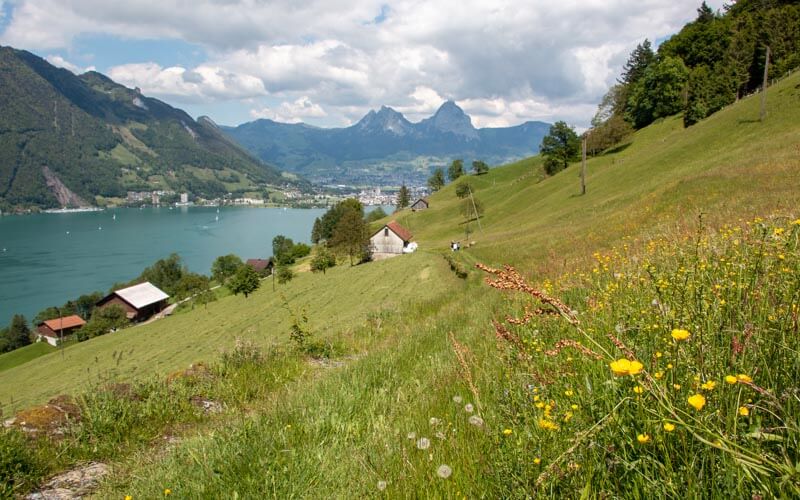
Constant great views of the lake for the rest of the hike.

View of the Grosser Mythen peak in the distance.

At this, we chose to take the shorter route to Treib instead of Rütli, saving about 2.5 km.

Lovely flower-filled meadows here.
Keep following signs to Treib.

Is there anything more Swiss than this landscape?


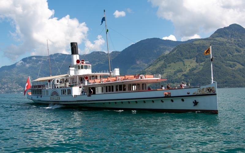
Ending in Treib
Arriving in Treib where we catch the ferry back to Beckenried. The boat only runs once an hour, so keep an eye on your watch. We missed the boat by 10 mins and had to wait 50 mins for the next boat. Check schedule on lakelucerne.ch

From the boat, you can see the trail you just walked along these hills.

Absolutely loved riding on the water back to our starting point.

Ending in Beckenried where our car was parked.

I hope you enjoy this hike.
See also 15 Spring Flower Hikes in Switzerland (April to June)


