It’s so frustrating when you see pretty pictures of Switzerland on social media, but they don’t tell you how to get there. In this post, I’ve selected the most popular Switzerland views, give you directions how to get there, and share tips on where to take the best pic.
All of these viewpoints are easy to reach for the average visitor, no long or dangerous hikes. And no drones necessary for a beautiful picture.
1. Appenzell – Berggasthaus Aescher
This restaurant built into the side of the cliffs has become quite famous on social media in recent years. The scene captures many typical Swiss elements in one shot: rustic wooden mountain hut, bright green alpine meadows, and dramatic mountain peaks.
It’s easy to reach with a cable car and short walk down though a cave and around the mountain on a wooden walkway. The best photo spot is on the path leading to the restaurant with the peaks in the background, as shown here.
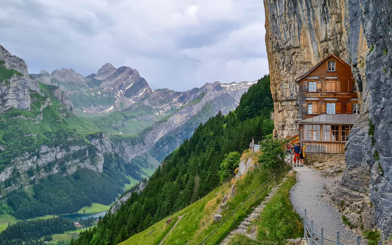
It’s a nice place to enjoy a traditional Swiss meal with a view of the Alpstein mountain range. But they don’t take reservations, so you may have to wait a long time on busy weekends.
If you like to hike, there is a steep trail down the mountain to the Seealpsee lake below. But it’s quite dangerous, so we only recommend it for experienced hikers with a head for heights.
How to get to there
Drive to take a train to Wasserauen. The Ebenalp cable car station is a short walk from the train station and metered parking lots.
Buy a ticket here and ride the cable car up the mountain to Ebenalp. Then follow the trail down to the cliff restaurant, abou a 20 min walk.
Learn more about visiting Berggasthaus Aescher
2. Aletsch Arena – Bettmerhorn Glacier Viewpoint
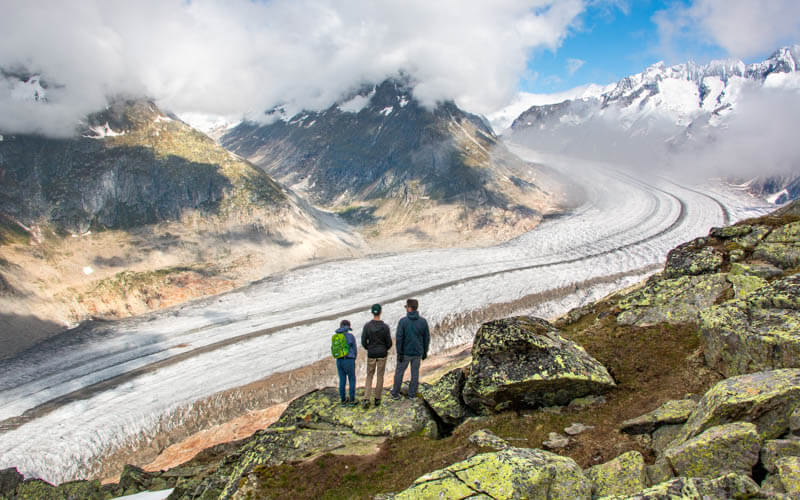
The Aletsch Glacier is the longest in the alps, currently at about 20km but sadly shrinking fast. You can see it from the Jungfraujoch near Interlaken. But our favorite photo spot is from the Aletsch Arena mountain resort on the southern side of the glacier. From here, you can really appreciate the big curve of the ice as it slowly snakes down the valley.
The Aletsch Arena has three viewpoints, Eggishorn, Bettmerhorn, and Moosfluh, each accessed from cable cars in different alpine villages. We like them all, but Bettmerhorn is probably the best choice for most visitors because it has more services and good hiking options.
From the top of the cable car, it’s a short walk on an obstacle free path to a fenced viewpoint over the glacier. But for a better pic in a more natural setting, wander on the rocks a little below this official viewpoint, as shown below.
How to get to there
The Aletsch Arena is located in southern Switzerland, about an hour drive north of Zermatt. Drive or take a train to Betten, where you’ll find the cable car station. Buy a return ticket to Bettmerhorn, which includes all mountain transport to get you to the viewpoint.
Start by riding the cable car up to the Bettmeralp alpine village. Then a short walk through the village to the Bettmerhorn gondola station (see on map). Then ride the gondola up to Bettmerhorn (see on map). At the top, there is a restaurant and right outside the gondola station, there is a short path leading to the glacier viewpoint.
Learn more about visiting Bettmerhorn
3. Zermatt – Riffelsee
The Riffelsee lake is the perfect place for a photo with the Matterhorn. If you’re lucky enough to have no wind, the peak will be reflected in the water giving you the classic shot.
This lake is easy to reach with a mountain train and five minute walk, no strenuous hiking involved. It’s a popular spot for tourists, so you might have to wait a minute to get a pic without a bunch of random people in it.
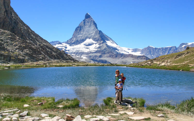
For a bit more peace & quiet, we suggest hiking at least a bit down the trail towards Riffelberg (the next train stop down the mountain). You’ll leave most people behind and get plenty more epic shots of the Matterhorn. See our suggested Zermatt hikes.
You can visit this area in winter, with a winter hiking trail passing by the lake. But since the water is covered with snow, it’s not quite the same look. .
How to get there
Get yourself to Zermatt (see on map). Since Zermatt is a car-free village, if you are coming by car, you’ll need to park in Täsch and take a train into Zermatt (about a 15 mins ride).
From the Zermatt train station, walk across the street to the Gornergrat cogwheel mountain train (see on map). Buy a ticket and ride up to Rotenboden, one stop from the top (see on map). Walk five mins on a dirt path down to the lake.
Learn more about visiting the Riffelsee
4. Grindelwald First Cliff Walk
The Grindelwald First cliff walk is one of the most dramatic viewpoints in the Jungfrau Region. It’s also extremely easy to reach, by riding a gondola up the mountain then a short walk on a metal walkway to the platform shown here. From here, you have a view of many huge mountains, including the Eiger directly in front of you.
People line up to take pictures at the end of the platform shown here. But it’s much better if the photographer takes the photo from the walkway below the platform. This angle shows where the people are standing high in the area, instead of just their faces against a pretty background.

You can visit this viewpoint year round, even in winter. But we prefer summer when the valley and meadows are bright green. If you have time and energy after the cliff walk, we suggest hiking the trail from First out to the Bachalpsee lake, where you can capture many more amazing pics (also possible in winter).
How to get to there
Get yourself to the Grindelwald village south of Interlaken. By car, we suggest parking at Parkhaus Sportzentrum: Dorfstrasse 110, 3818 Grindelwald. By train, ride to the Grindelwald station, not Grindelwald Terminal. Then a 10 mins through the village to the Grindelwald First gondola station (see on map).
Buy a return ticket to Grindlelwald First. Ride the gondola to the final station at the top, about a 30 mins ride. The cliff walk is on the mountain below the gondola station. Just follow signs to the cliff walk, walking straight out of the gondola onto the dirt path that leads towards the mountains.
After a couple minutes, take a sharp left, leaving the main path (which leads to the Bachalpsee lake), and enter the metal walkway that marks the start of the cliff walk. The walkway is a loop that ends at the restaurant and gondola station.
Learn more about visiting Grindelwald First
5. Valle Verzasca “Ponte dei Salti” bridge
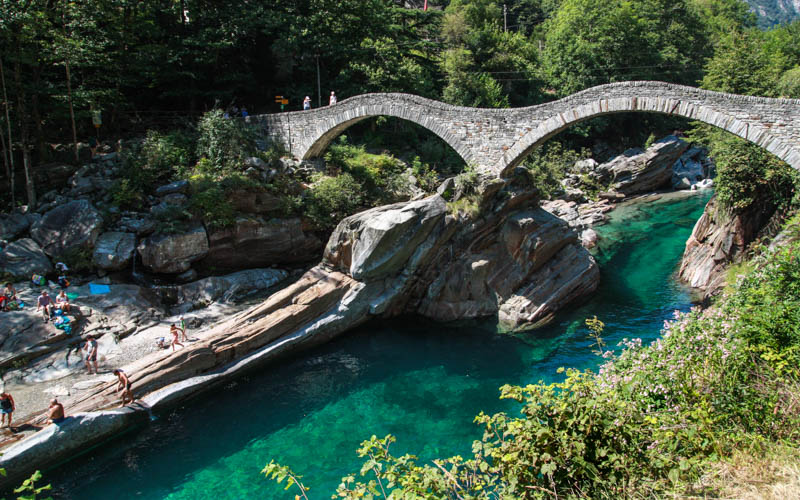
You’ve probably seen videos of people diving off this bridge into the crystal clear water below. This iconic bridge is located near Locarno in the Ticino region of southern Switzerland. You can drive or take a bus directly to the bridge, which is right on the side of the road.
You can get nice pics from the road. But even if you aren’t swimming, we suggest crossing the bridge and walking bit on the rocks down river. Then you can get a picture with the clear water in the foreground as you look up at the bridge.
How to get to there
The bridge is located in Lavertezzo in the Verzasca valley (see on map). By car, there is a metered parking areas near the bridge at 46°15’44.6″N 8°49’51.7″E. Or take a bus from Locarno and get off at Lavertezzo, Paese.
Learn more about visiting Valle Verzasca
6. Saxer Lücke
When I first saw these spiky peaks on Instagram, the pics made it seem that it was quite difficult to hike there. But turns out, there’s a cable car nearby and only a pretty easy 3km hike to get there. I even took my 73 year old father with bad knees on this trail and it was fine as long as we kept a slow pace.
The trail is a rocky path with stairs and often steep slopes on the sides. So best with hiking experience and no fear of heights. But it’s not super difficult and has minimal elevation gain/descent.
We think the best photo spot is on the little hills a few minutes before you reach the peaks. It’s slightly off trail, so no one else will be in your photo. If you have a flaire for the dramatic, there’s plenty of room to change into a costume and do your favorite poses: headstands, running with a flowing dress, jumping in the air, etc.
AdLooking for the best online services?
Explore top-rated platforms and secure your discount before it expires.
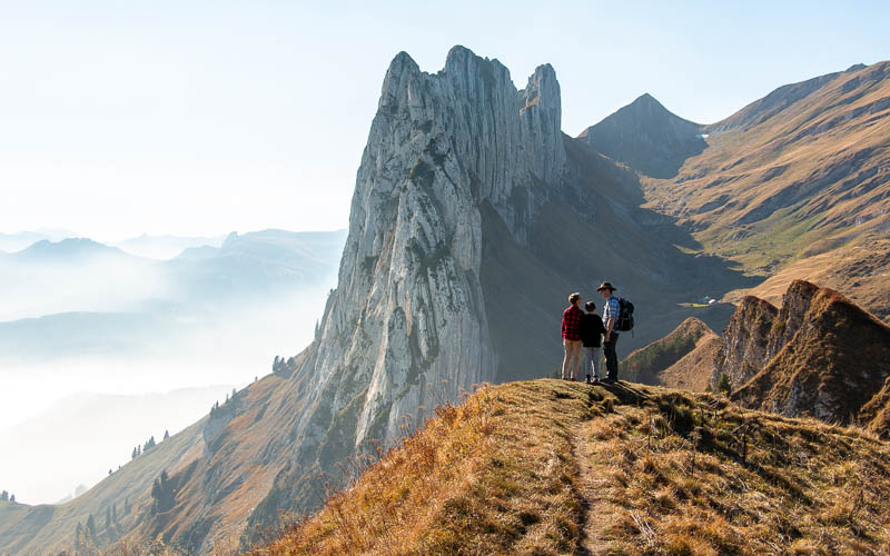
If you have time and energy, we highly recommend hiking a bit past the peaks, down to the lovely Fälensee lake. The mountain restaurant there has the best Rösti in the alps, deep fried if I’m not mistaken. Absolutely delicious.
How to get there
The Saxer Lücke peaks are located in eastern Switzerland, near the Liechtenstein border. You reach the trail with the Frümsen-Stäubern cable car (47°14’51.5″N 9°28’14.0″E). There is limited parking next to the cable car. The nearest bus stop is Frümsen, Luftseilbahn Staubern, about a 500m walk from the station.
Buy your cable car ticket from the machine and scan it at the turnstile to enter. There is a hotel/restaurant at the top, with nice views, hearty food and a toilet. Follow the yellow trail signs to “Saxerlücke,” a little over an hour depending on your pace. Return the way you came.
Learn more about the Saxer Lücke viewpoint
7. Lungernsee
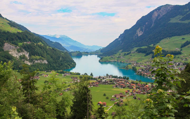
This popular viewpoint is free to visit, since it’s right on the side of the road, no gondola required. Many people and bus tours stop here on their way as they drive over the mountain pass connecting Lucerne and Interlaken.
The view is of the beautiful Lungernsee lake and surrounding countryside that has that classic super green Swiss look. If you have time, we also suggest walking around this lake for many more lovely pictures.
How to get there
This viewpoint is located at 46°46’32.4″N 8°08’35.4″E. It’s a small turnout on the road leading over the Brünig pass, just west of the Lungern village. You can only reach this by car as there is no bus stop nearby.
8. Stäuben Falls near Lucerne
Maybe it’s just me, but I saw so many Reels and TikToks of these falls in the last couple years. After searching for hours online, I couldn’t find any clear info about how to get there. So I did a reconnaissance mission and it turns out, it’s pretty easy to get to the falls.
The falls viewpoint is located in a tiny hamlet called Äsch (see on map), where you’ll find a restaurant, picnic area and a few farm houses. My picture shows how close we could get to the falls, which was not very close. The land near the falls is private property and fenced off.
To reach this viewpoint, you can start in a neighboring village and walk up a service road. Or you can ride a cable car up the mountain and do a beautiful hike that loops down to the viewpoint.

I’ve seen videos of people frolicking up the path shown in my photo. But there is a sign next to that path asking you not to trespass on their property. I suggest you respect that request.
How to get there
If you are coming by public transport, take a train to Altdorf, then a bus to Unterschächen, Ribi. Then walk up the service road about 3 km to the falls.
If you are coming by car, there is a road leading directly to the falls viewpoint in Äsch and a small parking area near the cable car there (see on map). My understanding was that you have to pay a small fee to drive on this road. But the last time we visited in 2022, this road was closed to tourist traffic due to risk of rock fall. It is possible that this road may again open to tourist traffic. So consult the signs near this road carefully before driving on it.
If you cannot drive to Äsch, park in Unterschachen, then walk on the road to the falls. It looks like you might be able to park at 46°51’48.1″N 8°46’09.3″E, but I’m not positive. So definitely look at the signs to make sure it’s allowed to park there.
There is a small parking lot in Ribi, which is a bit closer to the falls (46°51’51.2″N 8°46’54.6″E). But only customers of the cable car are allowed to use this lot.
Learn more about visiting Stäuben Falls
9. Zurich city
Zurich is full of fantastic photo spots, with grand cathedrals and attractive old buildings set against the lake, river, and mountains in the distance. Once of the most popular photo opps is at the Lindenhof park (see on map), where you get a view of the old town and Grossmünster cathedral towers. This spot is part of every city walking tour, so it can be quite busy with tourists.

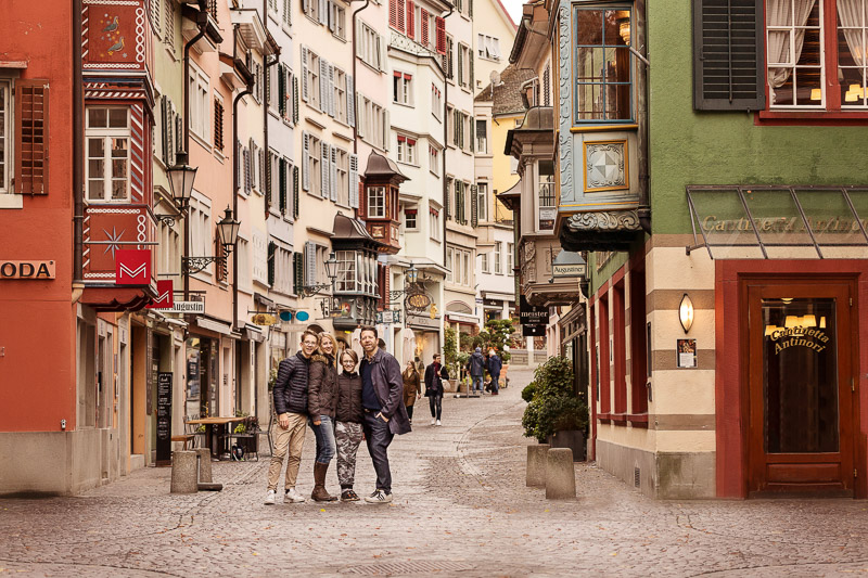
My other favorite photo spot in Zurich is on Augustinergasse (see on map), a charming pedestrian-only lane downtown. It has colorful facades, bay windows, vintage street lamps, and cobblestone.
This area is part of the bustling downtown shopping district. So best to visit before the shops open around 9:00 to get more empty streets. Even better on a Sunday when shops are closed, since delivery vehicles won’t be there either.
How to get there
These photo spots are close to each other and a short walk from the Rennweg tram stop. If you are coming from out of town, you can walk here from the Zurich HB main station in about 7 minutes.
If you are coming by car, the closest parking garage is Parkhaus Urania at Uraniastrasse 3, 8001 Zürich.
10. Lucerne Wooden Bridge
Lucerne is known for the Chapel Bridge, a long wooden bridge stretching across the Reuss river with a stone tower (see on map). It’s one of the main tourist attractions in the city and country.
We suggest taking the picture from the east side of the bridge. This angle means that Mt Pilatus is in the background, as well as the very attractive Jesuit church.
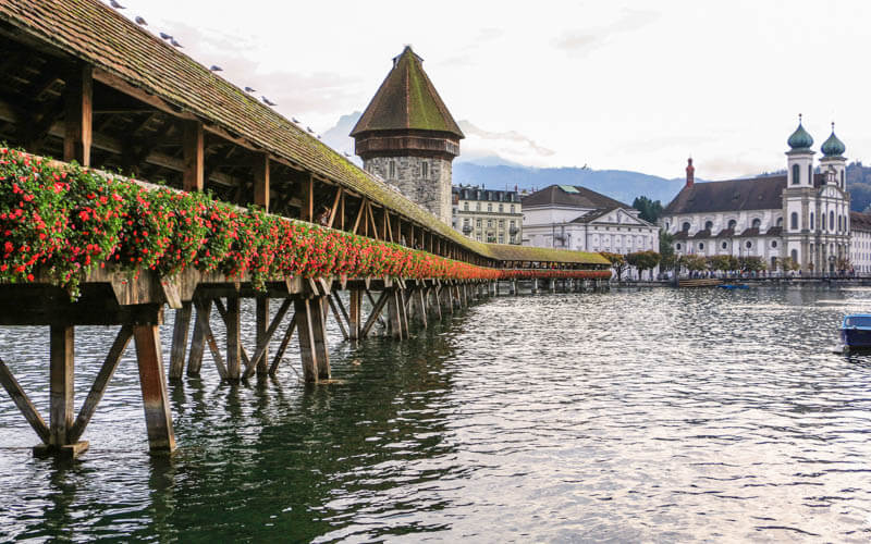
If you are there near sunset, we prefer the west side of the river, so you can get the warm light on the tower and bridge.

How to get there
The wooden bridge is a short walk from the Lucerne main train station. If you are coming by car, we suggest parking in the garages at the Lucerne train station or Parkhaus Altstadt (Baselstrasse 4, 6003 Luzern), which is a short walk down river from the bridge. There is also short term street parking along Bahnhofstrasse near the bridge. But it’s usually full.
See a Lucerne walking tour
Montreux Chillon Castle
The Chillon Castle sits on the shores of Lake Geneva, one of the most visited castles in Switzerland and Europe (see on map). You can tour the inside, seeing objects dating back to Roman times and visiting the pisson from the 16th century.
Many people take pictures with the castle from this small rock walkway near the boat dock, as shown below.
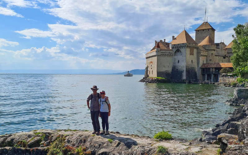
But we suggest walking to the north side of the castle, so your picture has the mountains in the background, as shown here. There are a couple rocks sticking into the water where your family can stand if that’s important.

How to get there
The castle is just south of Montreux, about 5 mins by car and 13 mins by train. The closest train station is Veytaux, Château de Chillon, which drops across the street from the castle. By car, there is metered street parking just south of the castle near the ferry dock – 46°24’46.3″N 6°55’47.5″E.
Learn more about Chillon Castle





