The Rochers de Naye is the highest mountain peak near Montreux, at just over 2000m. The vintage mountain train takes 55 mins to travel from Montreux to the top, with fantastic views the whole ride.
At the top, there are panorama viewpoints, two restaurants, a marmot enclosure, and alpine flower garden. Casual hikers can wander the top to peer over the cliffs, while serious hikers can start epic treks from here. We loved our visit and think it’s a must-do for any trip to the Montreux Riviera area.
Contents
Our visit was in collaboration with Montreux Riviera tourism, who hosted our trip.
| Location: | Montreux, Lake Geneva Region, western Switzerland |
| Address: | Montreux train station |
| Car: | Parking at Montreux train station (Avenue des Alpes 72, 1820 Montreux) 1hr mins from Geneva, 1hr10 from Bern, 2hr30 from Zürich |
| Train: | Montreux train station 1hr from Geneva, 1hr35 from Bern, 2hr40 from Zürich |
| Trail: | optional 1.5km wander at the top |
| Services: | restaurant, alpine garden, marmot enclosure |
| Cost 2024: | Adult CHF 72.80 Discount with Montreux Riviera Card, Swiss Travel Pass, Swiss Half Fare |
| Open: | train runs year round, hiking June thru October |
| More info: | mob.ch • webcams |
Overview of Rochers de Naye
The Rochers de Naye mountain list located above Montreux in western Switzerland (see on Google Maps). It is accessed with a cogwheel mountain train from Montreux.

It takes 55mins for the train to travel from Montreux to Rochers de Naye. This map gives an overview of what you’ll find at the top. The blue line is the train and yellow dotted lines are hiking paths.

This diagram shows the complex at the top of Rochers de Naye. There aren’t a lot of amusements like you find at other mountain peaks. There are just two restaurants – one with outdoor seating near the train stop. The other restaurant is built into the side of the cliff and is reached by a tunnel from where the train drops off.

At Christmas, Rochers de Naye hosts a special visit with Santa in the grotto at the cliff restaurant. For details, see my Montreux Christmas Market post.
Getting there
By train: Get yourself to the Montreux train station. Switch to track 8 where you can board the Rochers de Naye mountain train.
By car & cogwheel train: Drive to Montreux and park in a parking garage near the Montreux train station. The closest is Parking de la Gare (near Avenue des Alpes 72, 1820 Montreux). If that’s full, try Cite Center at Grand’ Rue 86, 1820 Montreux. Walk to the Montreux train station, buy your tickets and go to track 8 to board the Rochers de Naye mountain train.
Planning your day
Ticket Prices
In 2024, a round trip ticket to the top costs CHF 72.80/adult.
Discounts with Montreux Riviera Card, Swiss Travel Pass, Swiss Half Fare Card and children 6-16. Kids with a SBB Junior Card or under 6 ride free.
This journey is free with GA Travelcard.
You can buy tickets for the mountain train online on the MOB website or at the Golden Pass Center in the Montreux train station.
Check MOB website for current prices and operating times.
Operating times
The mountain train runs year round.
The train leaves hourly from Montreux. One hour at the top is sufficient if you are just catching the views. If you plan to eat and visit the alpine garden, maybe two hours.
Hiking options at Rochers de Naye
Most tourists simply ride up to catch the views, enjoy a meal with a view, and ride back down. But this area is popular for hiking as well. Here are a few we can suggest.
Rochers de Naye peak mini loop. From the restaurant, it’s a short climb 400m to the peak, then wander down the ridge to another cliff overlook, then traverse back to the mountain past the marmot enclosures. It’s a 1.5 km loop, easily done within an hour before the next train leaves. See trail map.
Panorama trail to Haut-de-Caux. This trail descends the west side of the mountain to the Haut-de-Caux train stop, 6.75km and 800m of descent. See trail map.
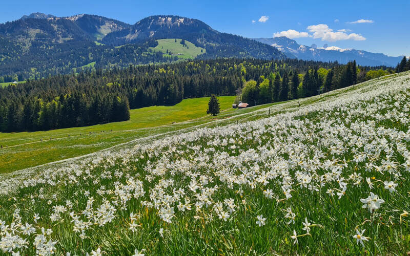
Narcissus trails. When you ride the train down, you can stop at the Haut-de-Caux or Glion stops to do one of the narcissus flower trails, which bloom late May to early June. Even if the flowers aren’t blooming, the trails are very beautiful. See trail map.
Via Alpina to Rossin. More serious hikers can trek from Rochers de Naye 19km to Rossiniere, which looks like an amazing journey. See details on SchweizMobil.
When we visited once at the end of May, there was still a lot of snow at the top and the trails weren’t nearly ready. When we visited again the first weekend of July, everything was green and the trails were in great condition.
Prime hiking season starts in late June and continues through mid-October. As always, check the trail and weather conditions before planning your outing.
Video of the trail
Photo story
1. Riding the cogwheel train to the top
At the Montreux train station, go to track 8 where you will board the vintage cogwheel train that goes up to Rochers de Naye. On sunny weekends, best to arrive at least 20 mins early to get tickets and queue for a good spot on the train.

It doesn’t matter where you site. Views are great on both sides of the train.

The views over Lac Leman get bigger and better the higher you climb.

You’ll pass a few mountain peaks on your way. This is Dent de Jaman which you could hike another time.

Arriving at Rochers de Naye
The train drops you off at a small complex at the top of the mountain shown here. There is a restaurant and toilet. From the train station, walk up the stairs to the restaurant terrace and to the viewpoint.

Near the restaurant, you get views like this down the mountain towards Lake Geneva.

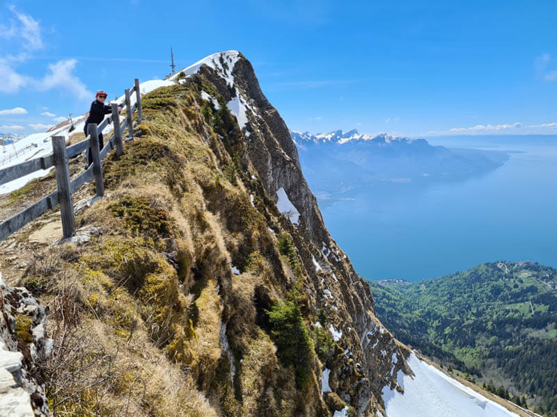
Hike up to Rochers de Naye peak
Behind the restaurant, there is a short path leading up to the peak above with a tower. The views are much better from up there. So if the trail is clear of snow, I highly recommend the short walk up.

This picture shows the path to the peak above the restaurant. It only takes about 10 mins but it climbs 70m of elevation, so it may feel a bit steep.

The path is a well built dirt path, a little rocky but not difficult.

Looking back at the train station.

The path leads to this enclosed observation deck.

The deck has fences making it a safe place to look over the cliffs.

View of Lake Geneva from the deck.

From the deck, you can walk back the way you came or follow the path along the ridge, which is more difficult.

The path along the ridge looks like this and leads down to a wider path below.

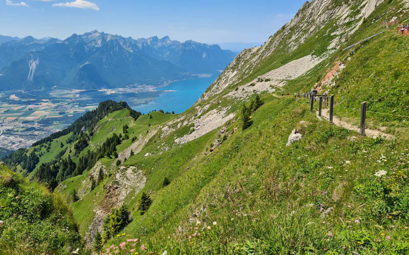
Easy walk to cliff overlook
Without or with the peak climb, you can follow a relatively easy path that traverses the mountain to this cliff overlook next to the cross. It takes about 10 mins from the restaurant and is easy walking in summer

From that viewpoint, you get this view of the peak and lake.

You can safely enjoy the cliff views from behind the fence and pretend that it was really hard to get here.
Looking back along the path back to the station.

When we were there in late May, the path had snow.

Keep walking along the ridge
You can continue walking along the ridge past the viewpoint. But the path gets narrower, more lumpy, and a bit steep in parts. So best if you have some experience hiking. The path leads down to the next train station below. But it’s quite steep and we wanted to visit the alpine garden, so we chose to just hike out and back.

I love ridge trails, so this part was really fun for me.

We walked until the path started to descend the mountain here. Then walked back the way we came.

Short walk to alpine garden
Starting around mid-June, the alpine flower garden opens, with many varieties of high elevation flowers and plants on display. It’s free to visit and is usually open from about mid-June through end of September.

It’s a 400m walk from the restaurant along the ridge on the path shown here, easy walking.

Picnic table along the path to the alpine garden.

Entrance to the alpine garden is free.

You wander on stairs through the garden built into the mountain.

There is a short loop path through the garden that wraps around the back side of this mountain. It’s a great view and well worth the extra steps.

View from the far side of the garden path, looking back at the Rochers-de-Naye station.

Hiking down from Rochers-de-Naye
If you want a longer hike, you can hike down from Rochers-de-Naye on the panorama trail to the Haut-de-Caux stop. The start of that trail is shown here. It’s 6.75 km with 800m of elevation descent – a proper mountain trail best done with sturdy shoes and hiking sticks. See trail map here.