Just outside Lucerne, this easy hike delivers unusually big views for such low-effort and low cost.
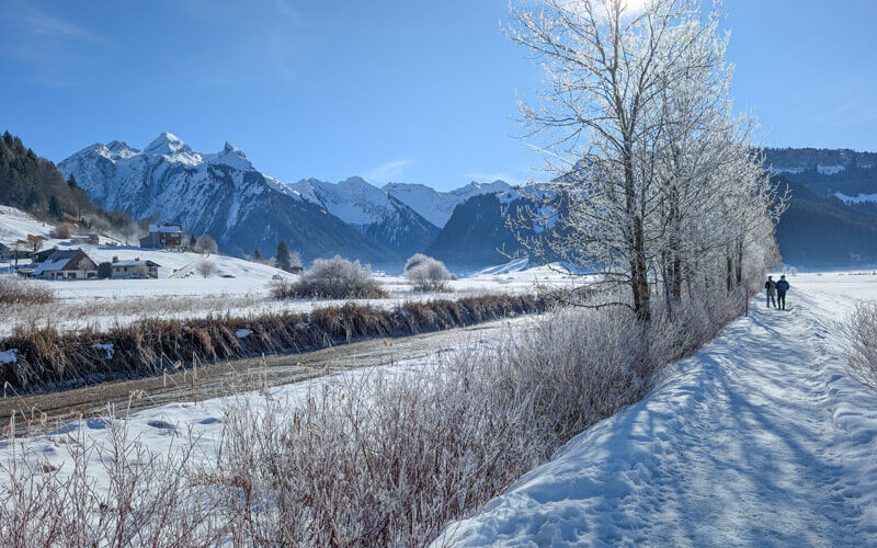
From open hillside paths, you’re looking straight across Lake Lucerne to Mt Pilatus, Stanserhorn and Mt Rigi, with no crowds or tourists.
The route is mostly used by locals, passing through meadows, farms pastures, patches of forest and quite neighborhoods, before finishing on the lakeside promenade in Lucerne city.
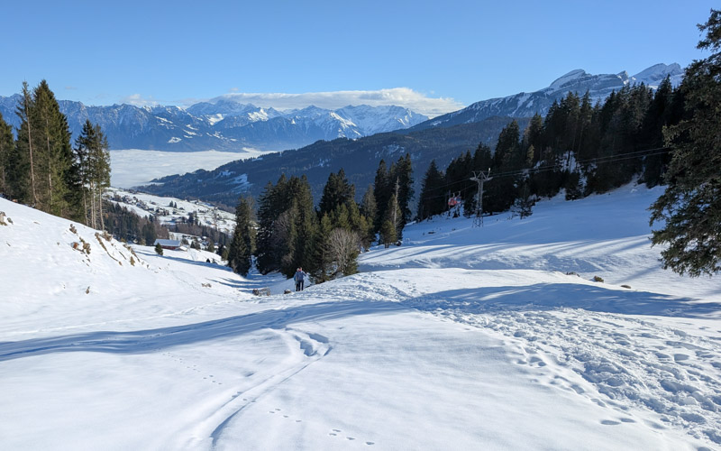
It’s a particularly good choice for spring, when the fruit trees are in bloom and mountain trails are still closed. Here, the open terrain means more sun and clear views.
Great for a budget, as costs are minimal, just parking or a short train ride. For a shorter day, I’ve included two loop variations, so you can walk as little as an hour.
Contents
Quick Info
| Region | Lucerne |
| Starting point: | Horw train station (6 mins from Luzern) |
| By car: | parking at Luzern Altstadt garage (Baselstrasse 4, 6003 Luzern) From Zürich 40 mins |
| By public transport: | Horw train station From Luicerne 6 mins, Zürich 53 mins |
| Trail: | 3h • ⬇️ trail map |
| Distance: | 11.4 km one way (shorter versions below) |
| Difficulty: | moderate • 325m up & down |
| Condition: | gravel and paved roads, some footpaths with uneven terrain |
| Elevation: | 435m to 600m |
| Open: | year round • trail status on SchweizMobil |
| Cost: | parking and train to connect ends of hike |
| Discounts | train free with Swiss Travel Pass, Saver Day Pass, GA |
| Services: | restaurants, playground, picnic with fire pits, swimming areas |
| More info: | SchweizMobil • weather • webcams |
Gallery
My pics are from our hike in late March. It’s much nicer starting mid April when the fruit trees are blooming and meadows more full of wildflowers.
Trail overview
This trail starts at the Horw train station and ends at the Luzern train station. If you arrive by car, you can park in Luzern and ride the train to the start of the trail.

I’ve included a few variations.
For a shorter hike, you can do just the panorama loop near Horw. By car, you can park on the hill, making for a short and easy walk (trail B). By train, you first need to hike up the hill before doing the loop (train C). I included trail maps for both below.
FAMILY TIP: These shorter loops have a puzzle path for kids – Raiffeisen Sumsi Trail. There are several puzzles to solve along the way (German only). Afterwards you can enter to win a prize.
For a longer hike, you can do the full Waldstätterweg Stage 4: Alpnachstad to Luzern, which is 21 km (trail D). Our trail here is the second half of this stage.
Hiking map
Our map shows the trail starting at the Horw train station and ending at the Luzern train station. Of course, you can hike in the opposite direction, which would be just as nice.

See map on Komoot • SchweizMobil • OutdoorActive
Shorter versions
You can do a much shorter version and still catch all the views. These loops are also convenient and less expensive if you are arriving by car (no fee for the train ride).
By car, you can park on the hill (Längacher parking) and do an 3km loop, easy and mostly flat. See trail map on SchweizMobil or Komoot.
By public transport, you can do a 5.7 km loop from the Horw train station. See trail map.
Longer version
My hike is the second half of Waldstätterweg Stage 4: Alpnachstad to Luzern, which is 21 km long. In this case, you would ride the train to Alpnachstad instead of Horw, then hike back to Luzern.
How to get there
This one way trail is located just outside Lucerne city, accessed by train.

By public transport:
Get to Luzern, then ride the train to Horw to start the trail. Or start hiking in Luzern and at the end, take the train from Horw back to Luzern.
The train ride between these stations is 6 mins, departures about every 15 mins.
By car:
For the one-way trail, we parked in the Luzern Altstadt parking garage (Baselstrasse 4, 6003 Luzern), which is the most convenient in the city.
Then we walked about 12 mins to the Luzern train station and rode the train to Horw (6 mins, departures about every 15 mins).
If you are starting in Horw, you can park at the Horw train station. If you are doing the short loop on the hill, you can park in the Längacher parking, shown below.

Planning your day
When to go
You can do this hike all year round. It’s a good choice for spring, especially in April when the fruit trees are blooming. In summer, it would be fun since you have the change to swim in the lake near the end of the hike.
Costs
Your only costs are for parking and/or train to connect the ends of the trail.
In 2026, we spent CHF 14 on the Luzern Altstadt parking garage for 6 hours. The one-way train tickets from Luzern to Horw were CHF 3.40/adult with Half Fare Card.
Farm shops
There are several self-service farm shops along the way where you can buy cheese, honey, jam and other farm products. Some accept TWINT, others cash only.
Where to eat
If you want to picnic, there are a few picnic areas with fire pits and endless benches at scenic points. If you need picnic supplies, best to go to the Coop at the Luzern station as there are no services in Horw.
If you end in Luzern, there are many restaurants in the city. In summer, there are a few cafes at the parks near the city.
If you end in Horw, you could eat at Seehotel Sternen Horw, which has a nice outdoor terrace for their restaurant. It’s about a 15 min walk from the Horw train station.
Photo story of trail
While the t
Train Luzern to Horw
It’s a one-way trail, so we chose to park in Luzern and ride to train to Horw. Then end in Luzern for lunch.
Before the hike, we had a quiet walk from the parking through Luzern old town to the train station. I stopped at SIP cafe for delicious coffee (also a breakfast menu here). If you need a proper breakfast, Mill’Feuille would be a good choice, with cozy indoor seating and nice outdoor tables along the river, as shown below.


On Saturdays, Luzern has a farmer’s market along the river, very fun to browse.


At Luzern train station, we caught the next train headed to Horw. They leave about every 15 mins, so you don’t have to plan ahead too much.


Starting trail in Horw
From the Horw train station, start by following signs to Kastanienbaum. You will walk through the neighborhood, about 15 mins to reach the lake. I found it helpful to check the trail on my mobile app a few times to make sure we were going the right way.


After a couple mins, the trail signs will have the green “Waldstätterweg” label. Follow those all the way to Luzern.


There are lots of attractive buildings to enjoy on this section.


You’ll pass a pretty nature reserve (Steinibachried). It has a wooden boardwalk that allows you to enjoy it without disturbing the nature.

Here’s where you’ll start having fantastic views of Mt Pilatus

The trail forks left before you reach the lake. But I suggest a little detour to the lakeside to get some pics. Seehotel Sternen Horw is here – their restaurant has an outdoor terrace with this view.

Hiking up to Dickiwald forest
Now you leave the lake and hike uphill towards the Dickiwald forest. You start on this service road.


Looking across to the Bürgenstock Resort on the cliffs.

Some of the farms you pass have self-service fridges and shops, like the one shown below.


The trail winds around the hills.

Looking back on the trail.


Now a short bit through the forest.

Walk through Horw neighborhood
Then dip down through the Horw village, walking on paved roads and sidewalks for a few minutes.


It’s not my favorite to walk along roads, but there are pretty things to see in this section.


At this point, the trail leaves the road and heads into nature again.

A bit uphill.

Some nice benches on this section.

A tiny bit in the forest.


Some of my favorite views of the lake on this part.


Now down through a neighborhood to the lake.

Keep an eye on the trail signs leading you to the lake. We checked our trail app a couple times to make sure.

Lakeside walk
Now you follow the lakeside all the way back to Lucerne.

Loved how quiet this part was. Great views and no crowds since you are still a couple km from the city.

You’ll pass by Strandbad Tribschen, a lakeside swimming park with a cafe, playground, volleyball, etc. In summer (from early May to early September) there is an entrance free, so you may have to walk around it. I’ll let you know about the detour after I do this trail again.

Lots of green space with lake views.

Tree lined promenades and parks that will be much nicer in late April then the leaves fill in.


Many pretty places to relax with a view of the city and lake.

You’ll pass by Ufschötti park, which has a large sandy beach where you can swim, no entrance fee.

Back in Lucerne city
When you get close to the city, you’ll pass by the boat docks.

Then the Inseli park near the train station.

This view is in front of the KKL center with art museum and performance space, next to the train station.

All done! Now enjoy lunch in the city before heading home. Mill’Feuille is also a favorite for lunch. See more restaurant recommendations in our Switzerland Travel Guide.