The “Küsnachter Tobel” trail is an easy walk along a stream through a forested ravine near Zurich. Although you can hike this trail year round, we usually visit in late April or May while we wait for the mountain snow to melt.
This trail is a good choice for families since it’s easy and all slightly downhill. With small kids, it can be a little long so you may want to bring an all-terrain stroller, which can be used on the mostly wide dirt path (only a few stairs near the beginning).
| Location: | Zurich Region |
| Address: | Start: Forch train station, Alte Forchstr 20, Forch, Switzerland End: Küsnacht train station, Bahnhofstrasse 1, 8700 Küsnacht |
| Car: | ~20 mins from Zurich |
| Train: | ~30 mins from Zurich |
| Trail: | 7 km one way, about 3 hours |
| Condition: | dirt, obstacle-free |
| Skill: | easy |
| Open: | year round, weather dependent |
| More info: | weather |
Location
This trail is very close to Zürich, just a little way down the Gold Coast.
Trail map
This trail starts at the Forch train station and ends in Küsnacht by Zurich lake. Click on the map for a bigger version that you can print.
Along the way, there are several picnic areas with fire pits and wood. But no toilets or restaurants until you arrive in Küsnacht.
Getting There
Since it’s a one way trail, it’s best to take the train so you don’t have to retrace your steps back to your car.
By public transport
From Zurich Stadelhofen tram stop (not the train station), ride the S18 Forchbahn train to the Forch, Bahnhof train station. It leaves every 15 minutes and the journey takes 26 mins..

The trail ends in Küsnacht, where you can either ride a train (see train station) or ferry back to Zurich (see ferry station).
The ferry runs about every hour- You can check the connections between Küsnacht ZH (See) and Zürich Bürkliplatz (See) on SBB.ch. Or check the current ferry timetable PDFs.
You can purchase a one way ticket from Stadelhofen to Forch (Zones 110 + 130). Then buy a one-way ticket back from Küsnacht to Zurich (Zones 110 + 140) – this works for either the ferry or train. Or you could buy a day ticket that includes Zones 110 + 130 + 140 (4 Zones). Either way, this ticket costs CHF 17.60/adult full price. Regular discounts apply.
By car
Since there is not an efficient bus/train connection between Forch and Küsnacht, it’s probably best to parking near Zurich Stadelhofen and use the instructions above for public transportation.
Alternatively, you could park at the Forch station at the beginning of the trail. At the end of the trail, you could take a bus/train back to Forch, about a 45 – 60 mins journey.
Video of trail
This short video shows our day on the trail in mid May 2018.
Photo story of the trail
Some of our pics are from the third week of March when the trees were still bare. The green pics are from mid May.
This is the Forch train station. Exit the station to the south and pass under the main road, walking towards the farm fields.

Follow the yellow trail signs toward Küsnacht.

You’ll walk on a dirt road through a long field as shown below…

Here’s what it looks like in May when the fields have started to grow.

The path through the fields leads you to this paved road. Turn left and walk along the street for a couple minutes, still following the yellow trail signs.

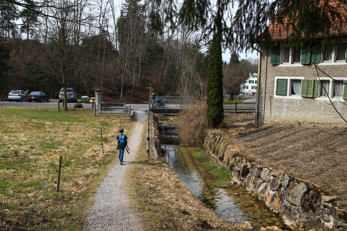
Walk along the sidewalk for a minute until you pass over a little river. The yellow trail sign points to your right, down some stairs to the river. You are now in the “tobel” ravine.

The trail should now look like this:

Or this in March and early April

Now just follow the river all the way to Küsnacht. It’s easy, just following the yellow signs.
The river has lots of little waterfalls along the way.

The trail comes out of the forest at one point and passes a fountain

You’ll pass a little farm with chickens. Just keep following the river.


Here are some of the trail signs you’ll see. Follow signs to Küsnachter Tobel. Don’t worry about the orange sign. It’s just telling you to keep your dogs on the leash or you’ll be fined.

Now the trail is back in the forest on a wide dirt road.

One of the picnic areas with a grill pit.

There are a few bridges to cross. There’s only a hand rail on one side, so with small children, you’ll need to help them cross safely.

Exploring the Dragon Cave
About two-thirds down the trail, you’ll find the “dragon cave” as shown above. The dragon sign faces the opposite way you are walking, so don’t miss it like we almost did. I had been promoting this dragon cave the whole trail and my boys would have been pretty upset if we didn’t find it. You have to scramble up the hillside to reach the cave and it’s not much, but kinda fun. The other dragon sign pictured above on the right, was next to a grill pit a few more minutes down the trail from the cave.


The cave in May.

There are a lot of grill pits along the way, some with tables and grills, others just fire pits. None with chopped wood as far as I could see. But you should be able to gather enough from the forest to make it work.

At the end of the trail, there is a “Steingarden,” aka stone garden, which is a collection of big rocks, all numbered and labeled with their geological details and where they came from.

It just looked like a bunch of rocks to us.

At the end of the Tobel trail, you emerge in Küsnacht village. Head straight west and in a few minutes you are at the train station to return home.
Or you can continue a couple more minutes to Lake Zurich, where there is a playground, lots of grass to run around on

Also a a lakefront restaurant.

Just north of the playground, you’ll find the ferry dock, where you can catch a boat back to Zurich. Check the schedule beforehand as the boats can run quite infrequently depending on the day and season.

I hope you enjoy the walk!






24 responses
Your website is a heavenly discovery for us! Already quite a few times our family used it for quick nature escapes from Zurich.
This river walk was fantastic. Very easy, eye pleasing and.. our kids didnt get bored:! So many waterfalls. Lots of gorgeous dragonflies; we were lucky to even see a deer, a crane and a squirrel.
Thank you once more for putting this route in the list!
ps we also almost missed the dragon cave. It was quite an exciting experience for kids!
What a lovely trip report! So glad your family enjoyed this outing. And so exciting to see so much wildlife.
Great walk – thanks for the tips 🙂 This is always the first place I come when planning hikes with kids (5&8) and this time also with their grandpa.
Some 2021 updates:
– the first (after around 2km) and third (after around 3km) fire pits have chopped wood to use. The third has it in a box so it’s nice and dry for days when it’s wet (unfortunately we only discovered this after a lot of hard work fire-starting at the first grillplatz).
– Right after the first fire pit there is a compost loo which was GREAT. So much easier than trying to help my daughter squat in the forest.
Thanks for all the helpful updated info! I should definitely do this walk again soon.
This is one of my favorite paths ever because it is so beautiful! We were there last Sunday and saw a ton of people (every fire pit we passed was occupied, which was fine because we hadn’t planned on grilling that day anyway). I’ve done it in the past with a stroller (no problems, the little one slept much of the way) and most recently with a 4 year old and grandparents, and everyone enjoys it. It’s a tad long for kids who are not used to walking (my 7-year old started complaining at the rock garden a few years ago but my 4 year old made it no problem this time around because we’ve been hiking a lot this summer) but totally do-able. There was a plastic container full of children’s books at the rock garden part this time, which was fun.
Cool tip about the children’s books. Wonder who did that.
Hey Tanya! Planning on going on this hike tomorrow. Just wanted to say thank you so much for all the information as well as the track on GPSies. It makes it so easy to just download the track to my Garmin. Gives me peace of mind knowing I’m on the right path, especially since a wrong turn with little ones can be painful! Thanks again!
So glad you like the GPSies maps! I love them and happy to know someone else also likes having detailed maps to help navigate.
I loved this trail. In the beginning before reaching the forest it was super hot, but then along the river it was fine. The signs were not to Küsnachter Tobel, but only Küsnacht. At one point the sign “Küsnachter Tobel” pointed away from the river, but we stayed on the path following the river. If we didn’t have the stroller we would maybe went to Wulp castle, that could be interesting. A new feature on the trail – at one of the picnic areas there is the water fountain with two different water origin – Quellwasser and Seewasser.
Thanks for the report! I’ll update the post about the trail signs. I’m excited to look for the new water fountain next time, very cool.
We were here yesterday with 3 yr old.. She did on her balance bike. Though 7 km was little long for her but we managed. Thank u for your posts which keeps us going..
Sounds fun! Yes, it’s a bit long for a 3yr old but proud of her for doing it. Good job all of you.
I am loving reading all about the many different hikes. We are new to Switzerland and are keen to explore. I wondered if this hike is possible for our four year old to go on his balance bike? He is not a great walker
I think a balance bike would probably work on this trail. It’s mostly a smooth dirt road and it’s relatively flat, so I don’t see why not. Let me know how it goes.
We did this lovely walk today and really enjoyed it. Took a bit longer than we thought as we planned to have lunch in Kusnacht but in hindsight we should have brought lunch with us as this would have made the walk a bit more relaxed. We took bus back to Zollikon where we live and this worked really well. Thanks for the great recommendation!
Thanks for the update. I should definitely go do this one again.
I did this walk again today, this time with my 2 week old, mother and dog. The rains this season have made their mark on the river but the trail is open again. One grand new addition to the walk is a huge boulder that came down the hill and landed on the side of the river. There are construction barriers at the moment as they are trying to make the area less susceptible to future mud/rock slides during rain. You can still get around it though and enjoy the impressive change in scenery.
We did this walk today with some family friends and we quite enjoyed it. There are loads of little waterfalls along the way, and it is very stroller friendly.
With a stop for lunch, and 5 kids and two strollers in tow, it actually took us 3.5 hours to complete!
I wouldn't mind taking the kids here again when the trees are in full bloom.
Thanks for this post Tanya!
We did this walk this weekend with our baby in the carrier and our 3-year old in the stroller. We loved it although our 3-year did often ask where the ducks were – the goal of the walk was to feed the ducks at the lake at the end of the walk. I think if it was any longer she wouldn't have been too happy. Thanks for the recommendation!
Thanks for the comment. I added the “stroller-friendly” label back in. Sorry about that. I also removed the “under construction” note. Thanks for being so helpful. I'm glad you enjoyed the hike.
Hello Tanya,
Some time ago I found this hike on your site. As we wanted to get out of the house yesterday I tried to find it once more but failed doing so at first. Luckily I remembered vagely what the trail is called otherwise I would not have been able to find it as it is not mentioned in the categorie 'stroller-friendly' (any longer). So perhaps you can add it once more to that list as it is an absolute perfect hike with a stroller. We enjoyed every minute of it! By the way no part of the trail is under construction anymore.
Hanneke
This is something I will definitely take friends and family to when they visit, and we'll go again. We did the whole thing with a 1 year old and the dog. The dog played in the water almost the whole way, we had a snack at the little farm by the road mentioned above- there's fresh water, grass, a bench and shade- we walked past the rest of the river (being sure to check out the caves too) and all the way down to the park at the lake, played a bit, had a bigger snack at the restaurant by the boat wharf then went home. We left Greifensee at 9:44 this morning and got home at 4:44 this afternoon. What a perfect day trip. Thanks again Tanya.
I'm glad you enjoyed this walk too. I agree, the view of the Greifensee is very nice. 🙂
Thanks for the detailed description! We also made this walk about a month ago (after you gave a link to the website with the route description) and had a good time as well.
Though, we were too lazy to walk close to the memorial, so we went half of the way and took a few pictures from the distance. 🙂 I would only add that it is a nice view on the Greifensee from the hill near the memorial.