This high elevation trail visits seven alpine lakes in a beautiful rocky landscape near the Gotthard pass. You start at a dam and large reservoir then hike up the mountain to discover a series of small alpine lakes nestled between peaks (Laghi Orsino, Valletta, & Orsirora).
Make sure to take the small detour to the Gatscholalücke, a mountain pass where get panorama views to lots mountains and glaciers on the other side.
The hike takes some effort, with switchbacks and uneven terrain. But the total elevation gain is not extreme, moderate difficulty suitable for older children and casual hikers.
Bring a picnic and take your time, stopping to enjoy the unique beauty of each lake along the way.
Contents
- Services
- What to bring and wear
- When to go
- 1. Walking to the dam
- 2. Walking along Lago di Lucendro
- 3. Hiking up the mountain
- 4. Lake 2 – Part 1 of Laghi della Valletta
- 5. Lake 3 – No Name
- 6. Lake 4 – Part 2 of Laghi della Valletta
- 7. Gatscholalücke mountain pass
- 8. Lake 5 – Part 1 of Laghi d’Orsirora
- 9. Lake 6 – Part 2 of Laghi d’Orsirora
- 10. Lake 7 – Lago d’Orsino
- 11. Loop back to dam
Quick Info
| Region | Gotthard Pass, Ticino Switzerland |
| By car: | Parking near dam: 46°33’38.5″N 8°33’31.1″E 1hr15 from Lucerne, 2hr10 from Zürich or Lugano |
| By public transport: | Bus stop: Gotthard Passhöhe + extra 1km to trail From: Lucerne/Lugano/Locarno 2hr20, Zürich 2hr50, |
| Trail: | 11 km loop • trail map |
| Duration: | about 4 hours |
| Difficulty: | moderate • 630 m up & down |
| Condition: | narrow mountain path, uneven terrain, rated T2 |
| Highest point: | highest point 2530m |
| Open: | July to mid October |
| Cost: | Free |
| Services: | no services |
| More info: | webcams |
Hiking map
This trail starts at the dam for Lago di Lucendro near the Gotthard pass. You start by walking to the top of the dam, then along the lake on a dirt road.
About halfway down the lake, you turn right on a footpath that climbs up the mountain, direction Bassa Valletta. It’s a narrow dirt footpath with switchbacks. Just follow the red/white trail markers as you visit three more lakes on your way up.
At about 5km, there is a fork in the trail with a trail sign. For a short detour, turn left direction Gatscholalücke and hike up about 10 mins to the mountain pass.
Enjoy the view, then hike back down to the trail sign and continue the loop, direction Laghi d’Orsirora. You pass three more lakes as you loop back to the dam.
See trail map on SchweizMobil • Komoot • AllTrails • OutdoorActive
Shorter, easier option (obstacle-free)
If you need an easier option, you can walk up to and along the first lake, where the path is a either a paved or dirt road, possible with strollers. From the parking, it’s 4km to the far side of the lake. But you can simply walk as far as you like then walk back the way you came.
Getting there
This hike starts on the Gotthard pass in northern Ticino (see on Google Maps). You can reach the trail by car or bus.

By car: Drive to the Gotthard Pass and park on the road leading to the dam (46°33’38.5″N 8°33’31.1″E). There are signs in Italian that indicate that you are not allowed to drive to the dam. We parked on the side the road, next to these signs.
By public transport: Get yourself to the Gotthard Passhöhe bus stop at the top of the Gotthard pass. Most connections will have you take a train to Airolo and transfer to the 110 bus that goes up the pass. In 2021, this bus runs from Airolo->Gotthard Passhöhe every 2 hours, at 8:10, 10:10, 12:10, etc. Check current schedule on SBB.ch.
When you get off the bus, use the map below to walk about 1.8km to reach the dam where the trail starts.
Planning your day
Services
There are no services along the trail – no mountain huts, no water, no toilets. There are services at the Gotthard pass including restaurants, hotel and WC.
What to bring and wear
Bring at least 1L of water and food to sustain you for at least 5 hours of hiking. Even in warm weather, bring layers include a rain jacket. The temperature and weather can change very quickly on the mountain pass and it can be very windy. I would bring a first kit including an emergency blanket to keep warm in case of injury while you wait for assistance.
Since the path has lots of uneven terrain and rocks, which can be slippery in wet weather, I suggest hiking shoes with good tread, hiking boots with ankle support if you have them. I found hiking sticks helpful some of the downhill sections that were steep with tall steps. If the weather is particularly warm, I could imagine that you might like to take a quick dip in the lake, so perhaps bring a swim suit and towel.
When to go
Since this is a high elevation trail, you may find snow here as late as mid-July and as early as mid-September. So make sure to check the weather and webcams carefully before heading out. The best time to hike here is late July through August.
Photo story of the trail
1. Walking to the dam
If you came by car, this is the closest you can park to the dam. That red circle sign means “Don’t drive down this road!” So park on the side of the road and walk to the dam. If you came by bus, you have to walk about a km before you get to this road.

At base of the dam, follow the paved road up to the top.

At this trail sign, keep on the road direction Lago di Lucendro, which is the big reservoir behind the dam. You will loop back later on the trail to your right.

2. Walking along Lago di Lucendro
The road leads to Lago di Lucendro shown here. Just keep walking on the dirt road along the lake.

There are lots of places to stop and lounge, good if you doing a short outing and not the whole hike.

3. Hiking up the mountain
At this trail sign, take the footpath to your right heading up the mountain, direction Bassa Valletta.

It’s a narrow dirt footpath, often with rocks and steps. It’s some work to go uphill but not dangerous.

View back down to Lago di Lucendro.

After about 40 mins, you reach this beautiful little marsh with millions of cotton flowers. So beautiful!!! I took so many pictures here but I’ll just put one here because we have a lot of lakes still to visit.

Follow the trail uphill over the rocks. You’re almost to the second lake.

4. Lake 2 – Part 1 of Laghi della Valletta
At the top of the climb, you can see the second lake – Lago Valletta

A rocky descent to the water.

Lovely views across the water.

The colors change as you walk around the lake.

The trail goes back up again but not too steep. Don’t get discouraged.

Looking back at lake 2.

5. Lake 3 – No Name
This mini lake is a surprise just after you leave lake 2.
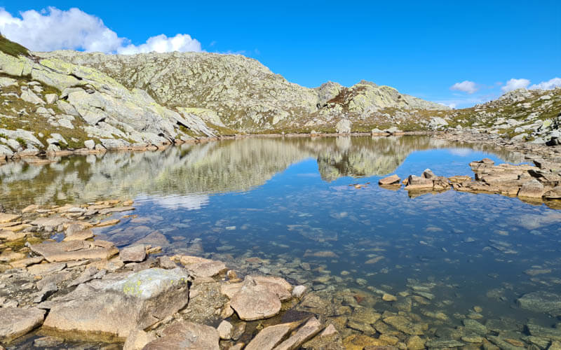
The best reflections here!

Back on the trail, heading to the next lake.

6. Lake 4 – Part 2 of Laghi della Valletta
This lake is technically also called Valletta but it’s quite separate from lake 2.

Make sure to leave the trail to get a pic of these cotton flowers on the far side of lake 4.

7. Gatscholalücke mountain pass
After lake 4, you’ll come to this trail sign. For a short detour, follow signs to Gatscholalücke, which is a mountain pass. It only took us 10 mins to get up there, definitely worth the tiny extra effort.

On the trail up to Gatscholalücke, looking back at Lake 4.

At the pass, you can look over the other side and see lots of other mountains.

That road you see in the distance leads to the Furkapass.

After enjoying the view from the pass, turn around and hike back down to that trail sign. Then continue the loop direction Laghi d’Orsirora.

8. Lake 5 – Part 1 of Laghi d’Orsirora
The trail continues across some lovely meadows with more cotton flowers.

Then you descend to Lake 5, part of Laghi d’Orsirora.

The trail goes down the water and walks around one end of the lake.

If you have time, it would be nice to leave the trail and explore more around this lake.

9. Lake 6 – Part 2 of Laghi d’Orsirora
Follow the trail to this rocky descent where lake 6 comes into view. This one is also part of Laghi d’Orsirora.

The trail stays high here and doesn’t go down to the water.

The trail continues through the rocks.

10. Lake 7 – Lago d’Orsino
The final lake: Lago d’Orsino.

This rock road was an interesting section of the trail.

The official trail stays high above the lake. My husband took that path and said it was really nice. My son and I took the other path down to the water and we really like that as well. The trails join up a few minutes after the lake.

More cotton flowers down by the water.

A few people were picnicking and lounging in the sun by the water here.

So beautiful with the golden hills in late September.

11. Loop back to dam
After the lake, you can see the Gotthard pass again. It’s a steep rocky descent for a few minutes.

More beautiful golden colors.

Now the path traverses the mountain, easy walking.

Last climb, just a few minutes to join the road that leads to the bottom of the dam.

Good job! You’re all done. I hope you enjoy this trail as much as we did!