This mountain trail visits six beautiful alpine lakes, each with their own character. Some big, some tiny, some busy with picnics and children splashing, others with quiet corners for relaxing. You’ll get panorama views across the whole region and reflections of the spiky peaks above.
It’s a proper hike with a little huffing and puffing as you climb the mountain. But you’ll see lots of average people and small children making their way, not just serious hikers. We combined this trail with the Corvatsch panorama trail, which is a nice option that I also describe below.
| Region: | Engadin, Graubünden, Switzerland |
| Start/end: | Sils Maria-Furtschellas cable car |
| Car: | Parking at cable car: Via Pas-chs 7514 Sils im Engadin (46°25’57.9″N 9°46’20.7″E) 15 mins from St. Moritz, 3hr30 from Zürich |
| Public transport: | Bus stop: Sils/Segl Maria,Furtschellas 35 mins from St. Moritz, 4hr from Zürich HB |
| Trail: | 6 km loop, about 3 hours |
| Elevation: | highest point 2650m |
| Skill: | moderate red/white mountain trail, Swiss trail rating T2 |
| Condition: | narrow footpath, no strollers |
| Services: | restaurant at start, no services along the trail |
| Cost 2022: | Round trip cable car CHF 39/adult Reductions for SBB GA, Half-fare and Swiss Travel Pass. Junior card accepted. Included in the Engadin Mountain Railways Included pass |
| Open: | July to mid-October, weather dependent |
| More info: | www.corvatsch.ch |
Location
This trail is located near St Mortiz in the Engadin region of southeastern Switzerland (see on Google Maps). It is accessed by the Sils Maria-Furtschellas cable car.

Hiking map
Here is the trail map provided by Furtschellas. It is a loop trail starting and ending at the Furtschellas cable car station, where you’ll find a restaurant, playground and WC. There are two official picnic areas with fire pits at the S-Chagila and Rhodonit lakes, as marked on the map. There are no other services along the trail.

Here is an interactive map you can download on your phone.
See interactive map on Komoot • SchweizMobil • OutdoorActive
Getting There
By car: Drive to Sils Maria and follow signs to the cable car – Via Pas-chs 7514 Sils im Engadin (46°25’57.9″N 9°46’20.7″E). There is a parking lot adjacent to the cable car station.
By public transport: Take a bus to Sils/Segl Maria,Furtschellasb., which is adjacent to the cable car station. This bus runs rather infrequently, so check the schedule carefully. In 2020, the last bus leaves Furtschellas at 17:32.
Ticket prices
You need a round trip ticket from Sils Maria to Furtschellas. In 2022, this costs CHF 39/adult. Reductions for SBB GA, Half-fare, Day pass, Swiss Travel Pass and children. SBB Junior Card and children under 6 ride free. You can pay with cash, credit cards and Reka checks. Check current prices.
Operating Times
The cable car runs every 30 mins from 8:30 – 16:30 (until 17:00 in summer). Summer season is from the end of June through mid-October. Check current operating times.
Photo story of trail
Starting at Furtschellas
At the top of the Furtschellas cable car, you’ll find a restaurant and a little playground. But best to get on the trail now. You’ve got some work ahead of you.

The trail starts straight up the mountain. Follow yellow signs with the green box – 721 Wasserweg.

After a few minutes, the trail splits into the loop. It doesn’t matter which way you go. I would probably suggest counterclockwise (direction Lejin Cristal – lake 1), so you visit the lakes in order 1-6 and end up at the picnic areas later in the hike. However, we hiked it backwards so some of my pics will show us hiking the wrong way.
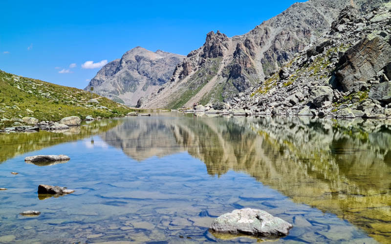
Lake 1 – Lejin Cristal
It’s steep climb up to the first lake, gaining about 300m of elevation over about 1.5km (took us about 40 mins walking down it). But the good news is you only have about 30m of elevation left of climbing then it’s basically all downhill the rest of the hike.

This is your first view of lake 1 and I must say, I was a little disappointed at first. It did not look like much until we got much closer.

For a pretty picture, get as close as you can get to these pretty cotton flowers with out destroying the marsh, then cleverly keep the cable car lines out of the picture.

Lake 2 – Lejin Magnetit
It’s only about 500m to the next lake, takes about 10 mins. Here’s the trail to lake 2, much easier than the first section (remember we walked this trail backwards, that’s why my husband is walking the “wrong” way).

This was my favorite lake because of the amazing reflections. You’ll need to tromp around to the various corners to get the best angles.
See how the reflection changes when I stand in a different place.

This lake has a baby sister pond next to it.

Lake 3 – Malachit
Now about 15 mins down to lake 3 (800m in distance, dropping 100m in elevation).

The lake looks a little hum drum from above, but it’s very pretty up close.

This was the largest lake, lots of people milling about and a couple even swimming.

I recommend walking all the way around as it has a very different look from different angles.

Looking back up the trail.

Lake 4 – Rhodonit
Now about 15 mins to lake 4 (about 700m, about 85m elevation descent). The trail down looks like this.

This lake was my least favorite because you have the ski lifts in view. But if you walk to the far side away from the trail, you get some nice reflections and it’s rather pretty.

This lake was the most crowded, probably because of the Feuerstelle (picnic area with fire pit).


Lake 5 – S-Chaglia
About 5 mins more to the smallest “lake”, more of a pond I’d say. So small that I wasn’t sure it actually was lake 5. The map shows a picnic area near here, but its not near the water. The fire pit by lake 4 is probably a better choice.

Lake 6 – Epidot
Sorry folks, but we skipped this lake. The trail splits and we took the lower trail because it was less climbing and our kids were tired. So I only got a picture of it from afar. We’ll just have to visit it next time. From Lake 5, it’s only about 10 mins but we didn’t know that at the time.

At the end, just follow trail signs back to Furtschellas where you can catch the cable car down the mountain. It takes about 60 mins from lake 6 to Furtschellas.


4 responses
Hi,
We are visiting St. Moritz this June and your website is super informative for us, especially these posts on hikes.
When was the time for your visit when you took picture of lake 1 with cotton flowers in this post? I am a big fan of cotton grass and am wondering what is the best season for that?
Thanks!
I was there in late July. So I think any time from July to August you should probably see these flowers. Good luck!
How do you access this trail from the Corvatsch Middle Station? I see the Panorama Trail, but can we cut over from that to the water trail?
Yes. When you reach the Lejin Rhodonit lake, instead of continuing straight to the Furtschellas cable car, you can turn left and follow signs up the mountain to Legin Malachit and keep following the Wasserweg loop to Furtschellas.