This hike was a surprise! Normally hikes to Swiss mountain huts are quite arduous. But this was one was so much easier than I expected – no steep climbs, just rolling hills most of the way. It’s long at 15km, but relatively mild and frequented by all ages.
We took the loop route recommend by my friend who has a chalet in area. I wholeheartedly agree with her suggestion, though it’s a tad longer than the most direct route. The views were gorgeous in both directions. I can’t wait to stay overnight in the hut someday and explore this area more.
Below you’ll find all the info you need to do this hike. I hope you enjoy it!
Contents
| Region: | Heidiland, Eastern Switzerland |
| Starting point: | Tannenboden-Maschgekamm gondola |
| By car: | Parking: Tannenboden, Flums (47°05’34.0″N 9°16’50.8″E) about 1hr15 from Zurich |
| By public transport: | Train station: Unterterzen + gondola to Tannenboden about 1hr15 from Zurich HB |
| Trail:1 | 15 km loop |
| Time: | 4.5 hours |
| Difficulty: | moderate |
| Condition: | narrow dirt path, uneven terrain |
| Elevation: | highest point 2116m |
| Open: | last June to mid October |
| Cost 2023: | CHF 33/adult, CHF 21.50/teen, children under 12 free Reductions for SBB GA and Half-fare card. |
| Extras: | food at hut and cable car |
| More info: | www.flumserberg.ch • webcam • forecast |
Gallery


Location
This trail is located at Flumserberg, a mountain resort in Eastern Switzerland, about 1 hour southeast of Zürich (see on Google Maps). You can drive or take a train to the gondola, which takes you to the start of the trail.

Trail overview
This trail starts at the top of the Tannenboden-Maschgenkamm BergJet gondola. It hikes out to the Spitzmeilen hut and loops back. You can eat lunch at the hut before looping back. You can also sleep at the hut (advanced booking required).

1. Tannenboden – parking and cable car station
2. Maschgenkamm – top of cable car and start of hike
3. Spitzmeilen hut
Hiking map
This hike is a 15 km loop. Since the elevation gain is distributed over a long distance, there are no particularly steep climbs or descents. It’s a dirt path that is often narrow and rocky with lots of uneven footing. It’s not particularly dangerous, but there are a few parts where the mountain slopes to one side off a narrow path.
View interactive trail map: Komoot • SchweizMobil • OutdoorActive
See more hikes at Flumserberg
How to get there
This trail is accessed from the Tannenboden-Maschgenkamm gondola (not to be confused with the Tannenheim-Prodalp gondola that also belongs to the Flumserberg resort).
By car
Drive to Flums, then up the mountain to Tannenboden. It’s a well-maintained two lane road but lots of winding curves, about 20 mins. Park in the metered lot next to the gondola. In 2022, it was CHF 6 for 5 hours.
If you prefer to not drive up the mountain, you can instead park at Unterterzen in the valley (near Walenseestrasse 18, 8882 Quarten). The parking is metered in Unterterzen, don’t forget to pay. At Unterterzen, you can ride a gondola up to Flumserberg Tannenboden, about a 20 min ride. There is an extra charge for this part of the journey. Once in Tannenboden, walk about 250m up the road to the Maschgenkamm gondola.
By public transport
Take a train to Unterterzen. The cable car station is conveniently adjacent to the train station. Take the gondola up to Tannenboden, then walk about 250m up the road to the Maschgenkamm gondola.
Ticket prices
From Tannenboden, you need a return ticket on the BergJet gondola from Tannenboden to Maschgenkamm. In 2023, this ticket costs CHF 33/adult, CHF 21.50/youth (age 12-18). Children under 12 accompanied by an adult ride free.
In all cases, reductions for SBB GA, Half-fare, children and other Swiss travel passes. SBB Junior card rides free. See current Flumserberg prices.
Opening hours
The Flumserberg lifts usually run from mid-June to mid-October. However, hiking trails may not be accessible until July. So check trail status before heading out. The BergJet gondola to Maschgenkamm usually runs from 8:15 to 16:45. See current operating times.
Where to eat
There is a self-service restaurant at the Maschgenkamm cable car station. At the hut, you can also get food and drinks. No other services between these two.
Photo story of trail
Riding up the gondola from Maschgenkamm.

Here’s the top of the Maschgenkamm gondola. There is a self-service restaurant here and toilets.

From Maschgenkamm, the trail starts on the easy Ziger Rundweg and Alpine Flower trail. You might be able to spy the hut way in the distance to your left.

As you reach the far side of the loop, you’ll see two parallel trails heading to the left. Both lead to the Spitzmeilen hut. We started on the higher trail and looped back on the lower trail.

The trail sign to Spitzmeilenhütte points to the lower trail. It’s about 30 mins longer if you start on the higher trail.

You can see the two parallel trails here. Both are narrow footpaths. Don’t take the trail that heads straight up the mountain to Leist – that’s the 7 Peak trail.

It’s a popular trail and we passed a lot of people. But mostly we were walking on our own.

The trail is rocky at times, but not super difficult.

Passing a few ponds.
Looking back at the trail passing under some peaks.

Hiking up and down lots of rolling hills.
After about 1 hour, you’ll reach this little lake, Sächserseeli. Some people were picnicking here and a few took a little swim. Looked cold!
Now heading downhill to join with the lower trail. Then we walk together the rest of the way to the hut.

This part of the trail had a lot of cows and sheep in early September.

Sheep on the other side of the trail. You walk along a cattle fence for awhile.

At this sign, turn right and you should see the hut very soon.

Make sure to follow signs to the Spitzmeilenhütte SAC, not the Spitzmeilen peak, which is quite a bit farther away.

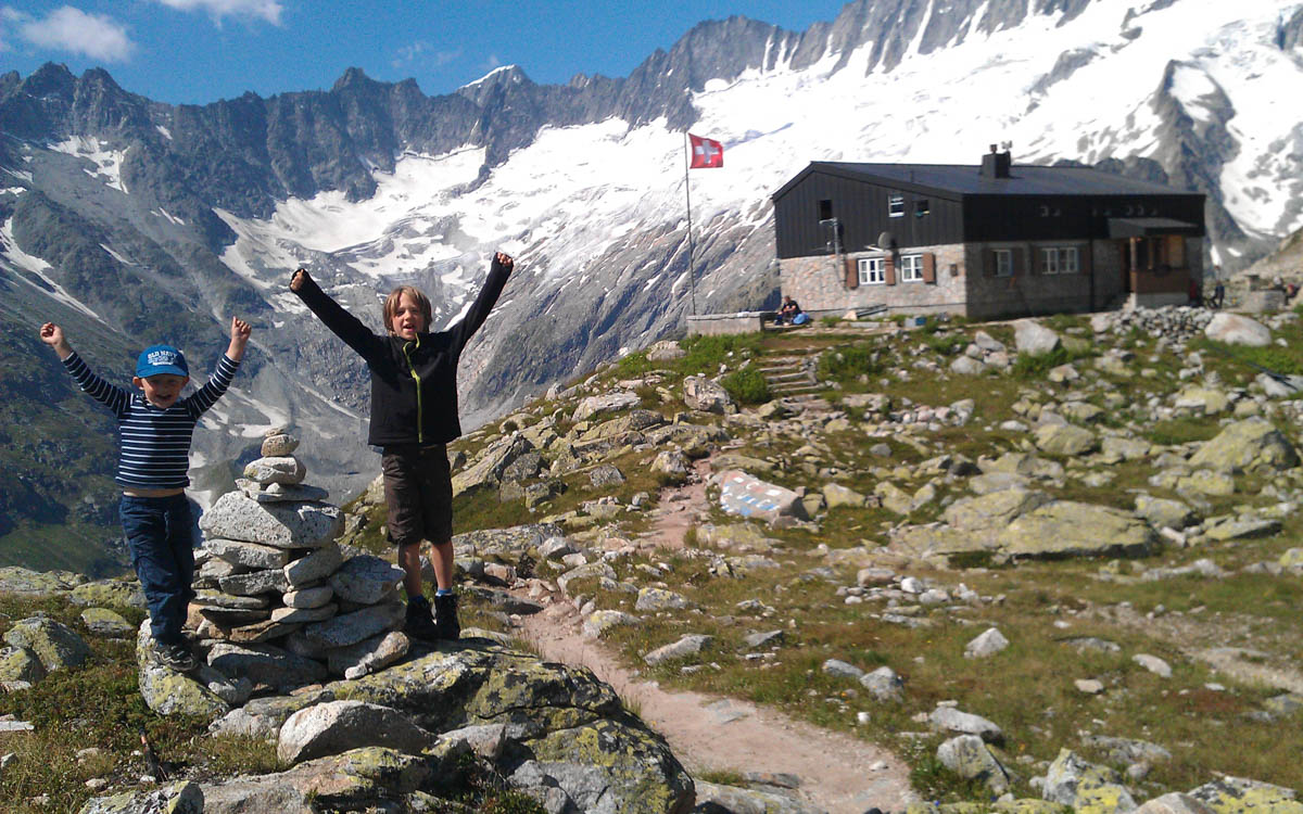
Arriving at the Spitzmeilenhütte. We hiked pretty fast and got there in 2 hours. Might take as long as 3 hours depending on your pace.

Very nice setting for this hut.
We arrived at noon on a busy Saturday, but we didn’t have trouble getting a table.

Hiking options from the hut. I’d love to hike up to the peak next time.

Menu at the hut. You can pay by cash or card.

We had the Spitzmeilenplättli with cheese. So pretty! It’s a lot of food, easy to share with 3-4 people.

Indoor seating at the hut if you are chilly.

Cliffs under the hut.
Now heading back to our starting point.

One trail branches left and heads to Proalp and Prokamm. That would not get us back to our car.

Same trail back but seemingly different views since we are facing a different direction.

Very serene landscape except for the occasional cow bell.
The path back on the lower trail was a bit smoother and easier.

Joining back to the Ziger trail where we have an easy 15 mins back to the cable car.

FAQ
Can I bring dogs on this trail?
Yes, dogs are welcome in the gondola and on the trail. Please keep dogs on the leash near cattle and hikers.
Can I bike to the hut?
Maybe. Although the trail to the hut is not an official biking trail, several mountain bikers passed us on the trail. I suggest asking the ticket office staff for advice. Learn more about mountain biking at Flumserberg.
What to wear
This hike is best done with hiking shoes with good tread. I found my hiking sticks helpful, but not entirely necessary.
Dress appropriate to the weather forecast. Since weather and temperatures can change quickly in the mountains, bring layers like a fleece and windbreaker/rain jacket even if you don’t expect bad weather. I found shorts ok since there were no sections with forests or thick brush.
Since there is no shade on the trail, it can very hot in summer. Make sure to bring sunscreen, sun hat, and sunglasses. Bring at least 1 L of water per person. You can purchase drinks at the hut and restaurant near the cable car.