We’ve had this lake on our list for years and finally we made it happen and it’s fantastic! From the alpine village Braunwald, we’ve done three different trails to the lake and each was beautiful with big mountain views and lots of wildflowers.
I have details for the three trail versions below, each with it’s advantages. I hope you make it there soon!
The lake is gorgeous, a perfect place for a picnic and skipping rocks. I’d also recommend a quick dip in the chilly water if you are brave, a great way to cool off after the hike.
Contents
| Location: | Glarnerland, Eastern Switzerland |
| Address: | Start: Linthal, Braunwaldbahn funicular (Stachelberg 2, 8783 Glarus Süd) End: Luchsingen-Brunnenberg cable car (Achern 11, 8775 Glarus Süd) |
| Car: | I suggest parking at Luchsingen-Hätzingen train station, the end of the hike about 1hr10 from Zürich. |
| Train: | Train station: Linthal, Braunwaldbahn 1hr30 from Zürich HB |
| Trail: | about 7.5 km one way, about 2h30 walking time |
| Elevation: | highest point 1900 m, total climb 70m, total descent 890m |
| Condition: | red/white mountain trail, dirt path, no strollers |
| Skill: | moderate |
| Open: | mid June to October (see website for trail conditions) |
| Cost 2023: | from CHF 19.30 – 35/adult SBB GA, Half-fare, Swiss Travel Pass, and Junior cards provide a partial discount |
| More info: | braunwald.ch • webcam • forecast |
Gallery


Trail Overview
There are three trails that lead from Braunwald to the Oberblegisee lake. In all cases, you start by riding a funicular to the Braunwald village. Then you can ride a mountain lift to Gumen or Grötzenbüel and start the hike there. Or you can start hiking directly from the Braunwald village. All versions converge before the last push to the lake.
We’ve done all three. Option B from Grötzenbüel is the most popular and easier trail. We like the version starting at Gumen (option A), which has the best views.

Map key:
- 1 = Braunwald parking, train station and funicular
- 2= Braunwald village
- 3 = Grötzenbüel gondola
- 4 = Gummen chair lift/gondola
- 5 = mountain restaurant
- 6 = Oberblegisee lake
- 7 = Brunnenberg – Luchsingen cable car top station
- 8 = Luchsingen cable car parking
- 9 = Luchsingen-Hätzingen train station
Hiking Maps
Here are the three trail options to get to the Oberblegisee.
Option A – “Panoramawanderweg” from Gumen
From the Braunwald village, you walk about 15 mins to the Gumen lift. Ride up the mountain to 1901m. Then hike across and down the mountain through beautiful alpine meadows. The trail joins the other trails at the river at Böbächi. Then about 30 mins to the lake and another 45 mins down to the Brunnenberg-Luchsingen cable car.
This version has the nicest views but has much more elevation descent and a more lumpy trail. It’s also the most expensive version.
Hike: 3 hr • 7.6 km • 70m up, 890m down
Trail map: Komoot • SchweizMobil • OutdoorActive
Option B – “Familienwanderweg” from Grötzenbüel
From the Braunwald village, walk about 10 mins to the Grötzenbüel gondola (see on map). Ride up to Grötzenbüel at 1559, where there is a restaurant. Follow the green Braunwald Oberblegisee Weg 810 signs.
You’ll traverse the mountain, descend through a forest, then cross a river at Böbächi. Then uphill another 30 mins to the lake, passing a mountain restaurant on the way. Then about 45 mins down to the cable car.
Hike: 3 hr • 8.3 km • 90m up, 570m down
Trail map: Komoot • SchweizMobil • OutdoorActive
Option C – “Ahornwanderung” from Braunwald
Instead of taking another mountain lift, you start the hike directly from the Braunwald village, walking on the village roads towards the Schweftiberg lift. Follow signs to Oberblegisee. It’s not as pretty at the start because you are walking on road for awhile before reaching the trail. After about 45 mins, you’ll join the “Familien” trail from above.
This is the least expensive version because you don’t pay for an additional lift above Braunwald. But it has the most elevation gain, as you have to walk from the village up to the trail.
Hike: 3 hr • 8.8 km • 300m up, 480m down
Trail map: Komoot • SchweizMobil • OutdoorActive
How to get there
This trail is located in Braunwald, an alpine village in the Glarnerland region of eastern Switzerland (see on Google Maps). You can access this trail by riding a funicular to the village, then a gondola to where the trail starts.

This is a one way hike, so you’ll need to use public transportation to return to your starting point. The trail starts at Linthtal, Braunwaldbahn and ends at Luchsingen-Hätzingen.
By public transport
Take a train to Linthal, Braunwaldbahn. The funicular to Braunwald is above the train station. If you pre-purchased a combo ticket that includes the funicular, you need to exchange your printed voucher for a funicular ticket (with a bar code for entry) at the ticket booth. On busy days, a staff member may be standing near the entrance with the tickets for you.
At the end of your hike, ride down the Brunnenberg cable car to Luchsingen. Then a short walk to the Luchsingen-Hätzingen train station where you can catch the train back to your starting point.
Trains from Luchsingen going east out of the Glarnerland valley generally leave hourly on the xx:51 (every 30 mins in the afternoons). Check current schedule.
By car
I recommend parking at the Luchsingen-Hätzingen train station, near your end point. Then when you finish your hike, your car is waiting for you instead of you waiting for the train back to to your car. There is a large dirt lot next to the train station where you can park.
From the Luchsingen-Hätzigen stop, take the train to Linthal, Braunwaldbahn, which drops you off near the funicular. This train connection goes about once an hour, sometimes every 30 mins. Check current schedule.
The Braunwald funicular entrance is directly above the train station. Ride the funicular up to Braunwald and start your day. You hike ends at the Brunnenberg-Luchsingen cable car, which you ride down to the valley. Then a short walk down to the train station to your car. Just follow the yellow signs with the train station symbol.
Planning your day
Ticket prices
For this trail, you’ll get a round trip “combo” ticket, which includes all mountain transport required for the hike and the train between Luchsingen and Linthal Braunwaldbahn.
The price is different depending on which hike version you choose. So when buying tickets, show them the trail you plan to do and you’ll get the right ticket.
Sample prices for 2024:
- Oberblegisee aia Gumen or Grötzenbüel – CHF 32/adult, CHF 16/child, under 6 free
- “Ahorn” trail from Braunwald – CHF 21/adult, CHF 12/child, under 6 free
You get a discount with GA, Half-fare, Swiss Travel Pass, and Junior Cards. Show these cards at the ticket office to get the discount.
SBB Railaway Combo Discount
Most years, you can book the “Familien” version of the Oberblegisee trip through SBB Railaway and get a discount on the train journey and mountain transport. See current prices on their website.
Opening times
This trail is usually open from late June to early October.
The Luchsingen lift at the end of the trail has the last ride down at 18:30 during summer and 17:30 starting in September. Don’t miss the last one down.
Photo story of the trail
In this photo story, I show the “Familienweg,” option B from above.
1. Riding up to Braunwald
The Braunwald funicular leaves on the :25 and :55, ride lasts 7 min. The funicular drops you off in the alpine village of Braunwald. At the top, you’ll find a kiosk and WC.

View from the top of the funicular.

2. Walk to Hüttenberg-Grötzenbüel cable car
Then a short walk to the Hüttenberg cable car (about 10 mins, 580m) on a dirt road, as shown on the map below. Follow the yellow trail signs to Hüttenberg.

It’s a bit uphill but not difficult.

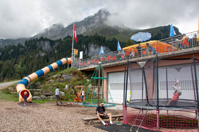
From Hüttenberg, ride the cable car up to Grotzenbüel. It runs every half hour on the :00 and :30, the ride is 10 mins up. At Grotzenbüel, you’ll find a nice playground with a trampoline, bouncy castle, swings, slides, picnic area, restaurant and WC.

View from the restaurant.

3. Start trail to Oberblegisee
To start hiking, follow trail signs to Oberblegisee. We followed this dirt road behind the restaurant.
Later I realized there is also a footpath leading from the east side of the restaurant as shown on the map below. That probably would be nicer.

Either way, they both join up at some barns and turn left at the crossing shown below. Make sure you are following signs to Oberblegisee.

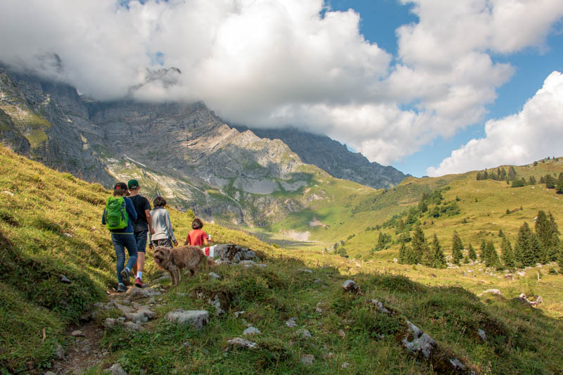
Making our way around the mountain.

A bit in the forest.

Coming around the corner for more mountain views.
4. Detour to Picnic Area
This little brown sign points to Flueboden, 2 min detour to a viewpoint to the valley and a nice picnic area with a fire pit, wood, tables, benches, and shelter.


5. Down to the river and back up
Back on the main path heading down to the river.

Crossing this river. Might be nice to explore up there another time.

Cross the river, then walk through the barn buildings to join the dirt path leading up the hill shown below. Do not take the dirt road, which leads to the cable car Brunnenberg, skipping the lake.

At the top of that little climb after the river, there is a mountain restaurant with a beautiful view (at about 4.4 km, about 1 km before the lake).

A bit more pretty hiking before we get to the lake.

On more narrow lumpy paths.

Some forest and rocks add some interest.

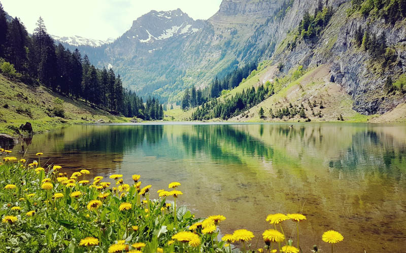
6. Arrival at the Oberblegisee lake
Almost there…
We were so happy to see the lake!!! The clouds had cleared and it was even warm enough to swim in the icy water. It took us about 2 hours with our kids to hike the 5.5 km to the lake, going slow and taking breaks.

There are no services at the lake, so make sure to bring a picnic. We’ve seen people building fires here but in summer 2018, there was a fire ban.

Lots of rocks to throw.

Lots of rocks to climb too.


I jumped in first but all the kids were hesitant because of the gooey mud on the lake bottom and little fish that were nipping their toes. Also the cold water was intense. But we all got in and laughed!!!

Even if you don’t plan to swim, maybe bring the suits just in case. Our boys swam in their underwear then had to hike the rest of the way without them. Not so comfortable. I’d also recommend bringing at least a small towel, which really helped us warm up faster after the cold water.
7. Hike down to Brunnenberg cable car
After the lake, follow trail signs down to Brunnenberg (about 2.8 km, about 40 mins) to catch the cable car to Luchsingen cable car (leaves on the :00 and :30, last car 17:30 or 18:30 in July/Aug).
We left very late and almost missed the last one down. We ran the whole way and luckily a local held the car for us.


You walk on a dirt road to Brunnenberg, a bit steep, descending over 300m over the 2.8km.

Pretty views in all directions.

Here’s the Brunnenberg cable car. It runs hourly on the half-hour, but we saw it run more frequently on off-schedule. I think they have a camera, so maybe they run it if they see people there. There’s no operator. We just got in the car and waited for it to automatically close.

It’s a short ride down to Luchsingen. Then a short walk to the Luchsingen train station where you can catch a train or pick up your car. Below is the path to the train station, which is on the right side of the map. Just follow the yellow trail signs with the train station symbol.

Please leave a comment if you do this hike and let me know how you like it.
Video of the trail
Here’s a video of our hike to the Oberblegisee in 2018.


2 responses
We did this today. Thanks for the detailed instructions.
Hope you had a great time! I love that lake.