
This ridge trail at Melchsee-Frutt is a beautiful mountain hike with a variety of terrain: ridges, rocky landscapes, rolling grassy hills, and quiet lakeshores. Even on a partly cloudy day, it was still really pretty as the clouds rolled over the peaks. It was perfect for our tweens at the time, a little more effort but not too difficult.
If you need something easier, try the short, easy stroller path around the lake.
| Location: | Central Switzerland |
| Car: | Parking: next to cable car: Stöckalp, 6067 Melchtal (46°48’11.8″N 8°16’45.8″E) 35 mins from Lucerne, 1hr20 from Zürich |
| Train: | Bus stop: Stöckalp 1hr10 from Lucerne, 2hr15 from Zürich |
| Trail: | 10 km loop, about 4 hrs with kids (shorter options below) |
| Elevation: | highest point 2150m, total climb/descent 300m |
| Condition: | red/white mountain trail, rocky dirt path, not suitable for strollers |
| Skill: | moderate |
| Open: | mid June to mid October |
| Cost 2023: | Day pass CHF 39/adult. Kids under 16 ride free. Discount for SBB GA & Half-fare. Free with Tell Pass. |
| More info: | www.melchsee-frutt.ch • webcam |
Gallery


And a little video to peak your interest.
Hiking map
Here is the summer hiking map for this area. See a larger interactive map here.

This trail starts at the top of the Stöckalp-Melchsee cable car, follows the ridge past the Bonistock hut, then down to a restaurant at Tannalp. This first half is a rocky alpine path, not suitable for strollers. Then you walk around the Tannalp lake and through cow pastures back to the Melchsee-Frutt village. This second half is easy walking on wide dirt paths.

See interactive trail map on SchweizMobil • Komoot • OutdoorActive
Trail alternatives
Skip the climb with cable car:
You can skip the first 200 m of elevation climb (over 2 km distance) by riding up the Distelboden cable car to Bonistock, which runs every 30 mins. You’ll need the slightly more expensive “day ticket” to cover this cable car ride. We took this cable car but later thought it would have been faster and cheaper to simply hike the full loop instead.
Shorten with shuttle bus:
At the far end of the loop, reach a restaurant and road. It’s another 5km along the lakes back to the Melchsee-Frutt gondola. Or you can ride the Fruttli-Zug shuttle that picks up here. This shuttle ride is covered by the “day ticket.”
Short & easy option:
Skip the ridge and just walk around the lakes. See details for Melchsee-Frutt Lake Walk.
Planning your day
Ticket prices
At a minimum, you need a return ticket on the Stöcklialp to Melchsee-Frutt gondola. In 2023, this costs CHF 37/adult.
If you want to skip the climb and ride the Bonistock cable car to the ridge, get the “day ticket” instead. This ticket also includes the Fruttli-Zug shuttle along the lakes, if you want to shorten your trail even more.
Discounts: Kids under 16 ride free. Discount for Swiss Travel Pass, Swiss Half Fare Card and GA. Free with Tell Pass.
Opening hours
The cable car runs from mid May through Mid October, daily from about 8:10 to 17:20. See current prices and operating hours here.
How to get there
The Melchsee-Frutt mountain resort is south of Lucerne, accessed by the Stöckalp cable car.

By car:
Drive to Sarnen, then turn east on Sarnenstrasse following signs to Stöckalp (46°48’11.8″N 8°16’45.8″E). There is a large metered parking lot next to the cable car station.
By public transport:
Take a train to Sarnen, then a bus to Stöckalp. The bus drops off at the cable car station.
Photo story of trail
1. Arrival in Melchsee-Frutt
The Stöckalp cable car drops you off in a little sleepy village full of vacation homes. Follow trails signs through these homes toward the first lake.
Note: If you are hiking up to Bonistock, instead of riding the Distelboden-Bonistock cable car, follow trail signs to Bonistock from here up that mountain straight ahead instead of walking toward the lake.

We planned to ride up the Distelboden cable car, so we walked out to the lake.

This free “panorama lift” takes you down to the lake.

The trail to Bonistock walks on the top of the cliffs on the left. We instead rode the elevator down to the paved road below, which leads to the Distelboden cable car, about a 1.4 km walk from Melchsee-Fruit. Took us about 20 mins to walk there. Since that cable car runs only every 30 mins (on the hour and half-hour), keep an eye on your time so you don’t have to wait too long.
At the lake shore, there are sun beds, pedalos for rent, a kiosk, etc. Keep following the paved road to Distelboden.

Last time, there was a wedding at this chapel.

2. Riding cable car up to Bonistock
Here is the Distelboden lift. Remember it runs every 30 mins on the hour and half-hour from 9:00–13:30 pm / 14:30–16:30. On busy days, it runs continuously.

This cable car drops you off at Bonistock, where you join the ridge trail. If you hiked up from the Melchsee-Frutt cable car, you join the ridge trail here.
At the top of the cable car, you’ll find this restaurant with a panorama terrace. We had some lunch there and it was nothing special. I’d bring a picnic if I were you.

3. Hiking the ridge
The ridge trail continues behind the restaurant, with the ridge and lake on your right.
Sometimes the trail is below the ridge.

The trail sometimes goes close to the edge, but not too close. But with little kids, keep them close to you just in case.

4. Down to Tannalp
At these trail signs, make sure you turn right, following signs to Tannalp.

After a couple switchbacks, you’ll continue walking east under the rocky cliffs. If you turn right (west) instead, you’ll walk back to Melchsee-Frutt under the cliffs.

I’m missing some pictures here (sorry!), but you join a service road for a bit, then an unmarked faint trail heads off into the grassland. If you miss it, you’ll be on the service road all the way to the lake, missing a bit of the trail but not a disaster.
This faint trail continues through the grass until it joins the road at Tannalp.

Here is Tannalp with a restaurant (and WC).

It’s about 5 km back to Melchsee-Frutt. It’s a more direct route walking on the road, but prettier if you walk on the dirt path around the lake. Follow the signs to Tannensee to walk around the lake.

If you are tired and don’t want to hike back, you can catch this tourist “train” bus back to Melchsee-Frutt. It runs about once an hour.

Here is the train schedule and prices, also online here.

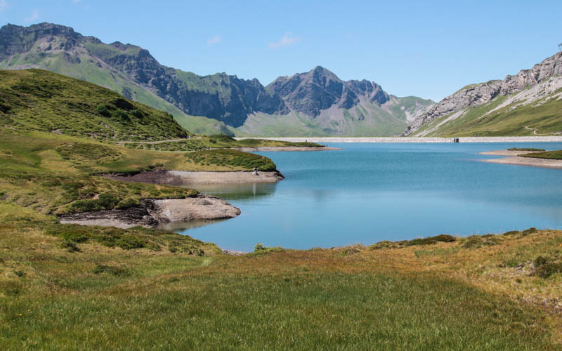
5. Walk around Tannalpsee lake
Here’s where the dirt path around the lake veers off the road.

Just follow this easy path down the lake.

Looking up to the ridge where you were walking earlier.

Looking back at Tannalp.

6. Fork at end of lake
At the far end of the lake, you can continue straight ahead on the dirt path. Or you can cross the dam to connect with the road. There is another bus station there if you want to catch the bus. We kept walking straight as shown below.

The path continues around this mound on some cow tracks.
Eventually you join back up with the paved road and make your way back to the first lake near the cable car. Follow signs back to the Melchsee-Frutt cable car.

There is a theme trail, the Fruttli-Weg, for children around this other lake with some fun play stations. Kids get a free booklet they can use during the trail and turn in for a reward, or something like that. A bit more about this trail on their website.

I hope you enjoy Melchsee-Frutt. Leave a comment and let me know what version of the trail you did.


