This beautiful mountain trail is close to Zürich and easily accessibly by car, no mountain transport needed. It climbs into the foothills, through field and forest. Then ascends the Chli Aubrig peak, giving you panorama views across rolling hills, a lake and many mountain peaks. Then you loop around the other side of the peak and hike back through more forest and boggy fields before returning to your starting point.
It’s a great choice for early spring before gondolas open and the snow melts elsewhere. It’s a tough climb at times, but well within the normal range and we saw a few families out there. We loved this trail, rivaling many hikes higher up the mountains that are more expensive to access.
Contents
| Location: | Zürich Region |
| Address: | Sattelegg Pass, Vorderthal |
| Car: | 40 mins from Zürich to Sattelegg Pass |
| Transit: | not possible |
| Trail: | 9.5 km loop (about 3 hrs) |
| Elevation: | highest point 1600m |
| Condition: | narrow dirt paths, no strollers |
| Skill: | moderate, 410m up/down |
| Open: | best late April through October |
| Cost: | free |
| Services: | restaurant at parking, cafe & water at half-way point, no fire pits |
| More info: | webcam |
Location
This trail is located southeast of Zürich in the hills near Einsiedeln.
Hiking Map
The trail is a loop, starting at the Sattelegg pass, as shown on the map below.
The trail is mostly a narrow dirt mountain trail, with some stairs. Not suitable for strollers. Best with sturdy shoes. Trekking poles are not necessary but helpful on the descent from the peak.
Services
There is a restaurant near the parking that reopens 13 May 2020. I didn’t see toilets near the parking, but you could probably use the ones at the restaurant.
At the halfway point near the peak, there is a small cafe and water fountain. The cafe wasn’t open when we were there and they didn’t post their opening times.
I didn’t see any fire pits or official picnic areas along the trail. Best to bring a cold picnic.
Getting There
Unfortunately, you cannot reach the trail head by public transportation.
By car: Drive to Sattelegg Pass as shown on the map below (GPS: 47°07’38.4″N 8°50’48.4″E). There is free parking at the pass, across from the restaurant. The trail starts there.
The day we were there, you could only drive on the west side of the pass. The east side from Siebnen was closed.
Starting the trail
Here’s the parking area. There are two trails leading from the south end of the parking, both leading to Chli Aubrig. We started on the west trail (on your right if you are facing the trail). We prefer that side.

Starting on a dirt road.

Headed up this hill to the left on some switchbacks.

Looking back on the trail

Now we can see our destination, Chli Aubrig, the peak on the left.

Once you reach the base of the peak, you wrap around the peak to the right.

You’re in the shade for a bit, with nice views across the valley.

Some stairs and some goats.

Looking back on the trail.

Arrival Wildegg & climb to peak
After about 3.4 km, you arrive at Wildegg shown below. I think that house is a little cafe in summer but it was closed when we were there. You’ll detour off the main trail to climb the peak, then return here and continue the loop.

It’s a tough climb up but short, only about 700m distance, gaining about 80m of elevation.

The last bit along the ridge to the very top.

Here’s the top.

Don’t forget to sign the guestbook.

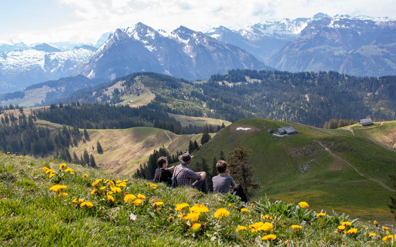
Now find a little space to chill with the view.
Have someone take your picture.

It’s a gorgeous view on the way back down.

Continue the loop
After you’ve hiked back to Wildegg, continue hiking on the trail to your left, following signs to Sattelegg. If you prefer, you could hike back the way you came.


At the next fork, follow signs to Sattelegg and head down to your left.

You’ll pass by a couple structures, nothing happening here.

You’ll descend through the forest for awhile.


Passing through Unter Alten 1310m, about 3 km left to go.

Then we enter the muddy, boggy fields. So much mud!

Across this whole field, for a good 10 mins or so, we had to choose our steps very carefully to avoid sinking deep in the mud. There were some sections with wooden walkways that were very helpful. But the rest was a wet, boggy mess.

Last bit of gradual uphill before the end, near that restaurant on the right.

Last few steps before reaching the parking lot. If you want to just drive up for a picnic, this would be a great spot for it.

Other hikes in this area…
Etzel Kulm loop hike – shorter and easy, still great views
Grosser Mythen – steep climb but shorter hike, lots of drama, cafe at the top
Pin this for later…


25 Responses
Hi! I did this hike two days ago, and it was amazing. I’ve checked the webcam many times and was afraid to go because the weather looks discouraging. When I arrived, everything looked much optimistic. I did the loop even in was raining the night before and yes it was really muddy but eventually it made my hike more challenging and fun. I think it’s a pitty to miss the loop because the forest parts on the way back were beautiful and maybe I like this side even more because of the amazing view of the Gross Aubrig and mix of forest, plains and other types of lndscapes. The path was empty the whole time, really relaxing and calm experience, I felt I am the only person on this planet :-)-
Thank you so much for your tips and ideals, it was incredibly helpful and much easier for me to do my hike alone as I felt couraged and knew what to expect thanks to your blog.
Can’t wait to go for another one!
Loved reading the report of your hike! I agree that the second half of the loop is pretty and gives nice variety to the hike. Just best to have waterproof shoes. A few people complained to me about that boggy section so I felt I had to say something about it.
Here is a bit of information about the house at Wildegg: https://march24.ch/articles/78280-auf-der-wildegg-zu-hause Lovely bit of history. The ex-owner is (or was) a well-known amateur musician (https://www.youtube.com/watch?v=QKLe0PqreqM)
Thanks for the fun background info about Wildegg. I’m sure our readers will enjoy this insight.
Hi!! Thank you very much for the blog and the amazing recommendations.
I would like to ask you whether this trail is open the whole year and you mean by “best” just the best time to go, althought it is open the rest of the year?
Thank you!
Ana
Good question. You can do this trail anytime there isn’t snow on the mountain. Any amount of snow or ice would make parts of this trail quite dangerous. This winter, there is very little snow, so you might be able to do this already in March. But usually, I wouldn’t try this trail until May and I would carefully check nearby webcams to see if all the snow has melted in this area.
Hi!
I was doing this track last week and I would highly discouraged anybody to take after any rain. I got stuck in a swamp (I was on the trial), I went as deep as 80cm and it was a really bad experience.
Hope it helps others.
Best
Kris
Very good point and thanks for sharing. It was so boggy when we were there and it hadn’t rained recently. I think if it has rained, it’s better to hike up and back rather than doing the loop.
We did this hike today, it was lovely, except that the muddy fields were likely ~45 minutes or even an hour long, likely because it rained heavily last night. Other than that, the hike was so pretty and perfect. And the restaurant had great food as well!
Those muddy fields are so annoying! Wish they would build more walkways there. I’m sure hikers are ruining the ground and the walkways would help.
I have biked up to Sattelegg many times, but had never seen this hike – and then, found it on your website. My wife and I did it, and it was exactly as you described. Perhaps the best hike I have done in this neighborhood.
So happy to help you find this hike and glad you enjoyed it!
My husband and son went there. It was beautiful, it was not the right time 😂 descending the summit, they were riding their asses in the snow and when the son fell into the snow up to his waist, they turned back 🙈 It is better to plan this trip in June – September 😅
Agreed, you need to wait for the snow to melt for this one. Better late May or early June.
Hi Tanya,
thanks for all the great work on the site. My family and i use it constantly.
I was looking around today and found that this and potentially other hikes may be missing from the main Map. Any ideas why?
thanks
josh bouchard
Thanks for letting me know. Sometimes I forget to add hikes to the map. I wish it happened automatically. I’ve been looking for a good plugin that automatically puts all my posts on a map but I haven’t found one yet.
Actually, Chli Aubrig is on the map. Possibly you had some of the categories on the left side of the map unchecked?
About how long does this hike take?
It took us about 3hrs walking time, with about another hour for lunch and other breaks.
Hello Tanya, thank you for the great experience! I was so happy to manage and enjoy it!
Your guides are extremely helpful, thanks a million!!!
Irena
So glad you enjoyed it! I think it’s such a special place even if it’s a bit of hard work.
Hello family, I just wanted to see thank you so much for all information and beautiful pictures. Really awesome. I am going to do this tour next week! We are Dutch family living here for 12 years now. Never a dul moment with me, us but lately girls ( twins) I need to convince more to go hiking. I did many, many trips but also in for new tours. ALl is very well described so I put a couple on our list!!! Since the weather now is great we are back in our shoes tomorrow! What a luck we have to live here. Sunny regards from Zurich, Astrid, Isabelle, Fillou
Thanks for the nice comment! Wishing you many happy adventures with your girls.
Looking to visit Switzerland as soon as it’s safe to travel. Who knows when that will be.. 🙁 We were supposed to come this month, but travel from the US not possible. Your posts are amazing and pictures just beautiful! Thank you for all the insight!
Thank you! Hope travel opens up soon so you can see our beautiful country.