This is the easiest walk to a glacier that you’ll find in Switzerland, perfect for families. It’s a wide gravel path, suitable for strollers, that leads directly to the glacier ice tongue feeding the river. There are 16 signposts along the way showing how the glacier has receded. Children can get an activity booklet to stamp at various posts along the way. The hike itself is beautiful, surrounded by mountains and forest and following a rushing river. A great choice if you are staying in the area.
Contents
| Location: | Engadin, Graubünden Switzerland |
| Address: | Morteratsch |
| Car: | Parking: 46°27’12.1″N 9°56’28.8″E 15 mins from St Moritz, 3 hours from Zurich |
| Train: | Train stop: Morteratsch 25 mins from St Moritz, 3hr40 from Zurich HB |
| Trail: | 6 km round trip, about 2 hours |
| Elevation: | highest point 2023m, 155m up/down |
| Condition: | wide dirt path, suitable for strollers |
| Skill: | easy |
| Open: | late June through October |
| More info: | engadin.ch |
Gallery


Trail overview
The trail starts at the Morteratsch train station and parking and leads up the valley to the glacier ice as shown here.

Hiking map
The trail is a wide dirt path, obstacle free and suitable for strollers. It’s about 3 km each way.

See map on Komoot • SchweizMobil • AllTrails • OutdoorActive
For a longer hike, consider the 5 km mountain hike to the Boval hut above the Morteratsch glacier.
Children’s theme trail
You can get a children’s activity booklet for this trail at the Pontresina Tourist Information, many hotels in the area and Camping Morteratsch near the trail. The booklet has a story, puzzles to solve, and stamps to collect various posts along the trail. You can return the booklet for a prize at the Pontresina Tourist Information office.
Getting There
The Morteratsch glacier is located near St Moritz in southeast Switzerland (see on Google Maps). You can easily reach the trail by car or train.

By transit:
Take a train to Pontresina, then another local train to Morteratsch. The train station drops off directly at the trail head.
By car:
Drive south of Pontresina and turn off at the Morteratsch sign. This takes you down a narrow paved road, past a camping area, to a big metered dirt parking lot near the train station (Morteratsch 4, 7504 Pontresina). You can park here for up to 5 days. The other small parking areas along the road are limited to a few hours.
To reach the trail, walk on the road up river past the hotel and cross the train tracks.
Photo story of the trail
The trail starts directly across from the train station and hotel restaurant. Cross the tracks to access the trail.

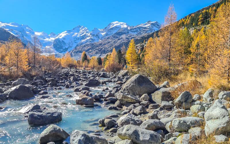
The trail follows the river all the way to the glacier.

The river is raging near the start of the trail. This is a nice place for a picnic before you head out, but no swimming, the water is too rough and cold.

Along the path, there are markers showing where the glacier was at various years. There are also QR Codes you can scan to get audio texts about the area.

Just stay on the wide gravel path in the valley, you won’t get lost. We were there on a hot day and the heat was a little relentless. Consider going on a cool day with some cloud cover.
The trail parallels the river.
Make sure to take a short detour to the water for nice photos.

Lots of places to stop for a picnic.

A view of the valley from above when we were hiking to the Boval hut.

And view down the valley, also from that same hike.

Just keep moving ahead.

How the trail looks in mid October.
The path leads directly to the ice.

Photo by Hansueli Krapf – CC BY-SA 3.0, Wikimedia
You can walk very close to the ice. But don’t walk on the ice without a guide and special equipment – it can be very dangerous!

Photo by Hansueli Krapf – CC BY-SA 3.0, Wikimedia
When you’re ready, walk back the way you came.


For a longer hike, consider the 5 km mountain hike to the Boval hut above the glacier.
See also: 10 Best Glaciers to Visit in Switzerland
Video of trail
Video from our hike the third weekend in Oct 2021.


4 responses
Hey Tanya, I just did this trail yesterday. And it was absolutely glorious. For the first time in 9 years I’ve actually seen the whole of the larch trees golden. What a sight. 😍. The train journey too was magnificent. I also noticed a lot of people getting off at Preda, which I hope is the right stop name. Would there be lovely trails there too.
I also seen your message that you’ve been interviewed and your blog and trial maps have been recognized. I wanted to say congratulations and way to go girl!!! All the best and wishing you all success. 🫡
Hi Jennifer, Thanks for all the kind words and congrats. I’m so happy you got to see the golden larches at their peak. I think people get off at Preda to visit the Palpuognasee, which is very lovely. I have a post on that too. It’s not too far of a walk from the Preda stop.
I am planning to be in St Moritz from 28 to 29 May, and would like to walk to the Morteratsch Glacier
Will this be possible and what other suggestions might you make while in the town of St Moritz. I am enroute by train from Tirano to Bremen with this short stopover in St Moritz
Thank you for your help
Elizabeth ……. from New Zealand
I think this path should be walkable when you go. It’s also possible as a winter trail, so it has been maintained as a walking path in winter. Might be muddy, but you can probably manage.