You’ll love this easy walk through the Rhine valley vineyards near Zürich, with mountain views and lots of places to lounge and picnic along the way.
The trail meanders through old villages filled with wineries (some open for tastings) as well as forests, fields and paths though the vineyards. The path is mostly paved, but I offer a completely obstacle free option below if you have a stroller or wheelchair.
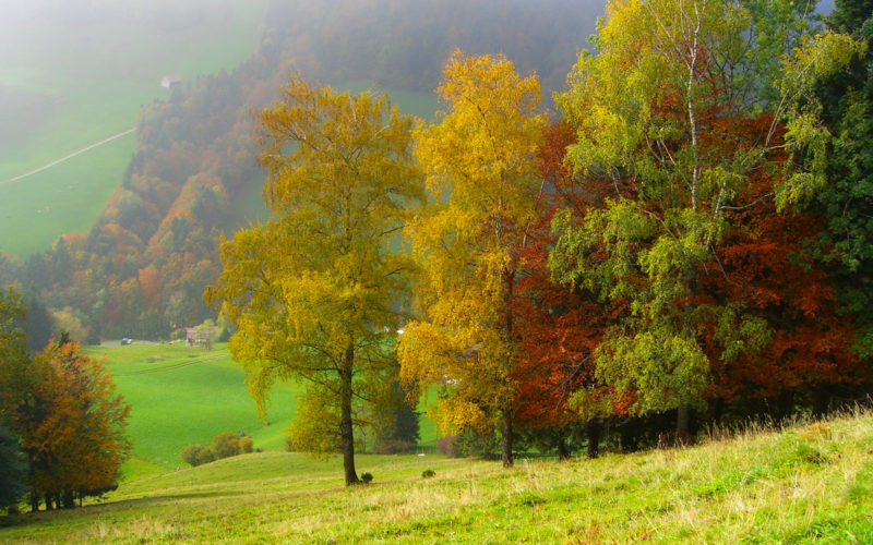
We went in late November and the fall colors were still very pretty even though the grapevines were bare. This hike would be also be very nice during fall harvest season when the grape leaves turn colors.
Also, this area is often sunny even when Zürich is stuck in the fog (check the webcams).
| Region | Rhein Valley, Eastern Switzerland |
| Address: | Maienfeld train station |
| By car: | Parking at Bahnhofstrasse 1, 7304 Maienfeld about 1hr from Zürich |
| By public transport: | Maienfeld train station about 1hr30 from Zürich HB |
| Trail: | 3h • ⬇️trail map |
| Distance: | 11 km loop |
| Difficulty: | easy (2/5) • 160m up/down easy |
| Condition: | mostly paved, short sections on narrow dirt path, stroller variation below |
| Elevation: | highest point 600m |
| Open: | year round, particularly nice in September/October |
| Cost: | free |
| Services: | along trail: restaurants, picnic areas, water fountains, WC |
| More info: | Heidiland.com • webcam• weather |
Trail map
I’ve marked the trail starting at the train station, where you can also find parking (details below).
The trail starts by wandering through the narrow streets of the Maienfeld old town. Then it heads into the countryside, passing through vineyards until it reaches a public park with a large grassy hill with benches, water fountain, grill pits and a WC.
Then a bit through the forest until you reach the village Fläsch, where you’ll pass a lot of wineries. Then up through the vineyards on the side of the mountain with great views of the valley.
The trail loops back on a parallel route, ending back at the Maienfeld train station.
See trail map on SchweizMobil • Komoot • AllTrails • OutdoorActive
Note: My map makes some adjustments/improvements to Heidiland’s suggested route, staying in the vineyards on the way back instead of walking down the river and crossing under the freeway. However, Heidiland’s map does mark all wineries and restaurants along the route, which you might find helpful.
Trail conditions
Most of the trail is paved or a wide dirt path, easy walking. Not too much elevation gain.
Shorter option:
You can easily shorten this by parking along the route and doing a shorter loop. For example, you could start at the Heidibrunnen park, where there is a bus stop and parking. Or start in Fläsch and just do the loop through the vineyards on the hill.
Stroller variation:
If you have a stroller, the only section that is not suitable for strollers is just before and just after the Heidibrunnen park, as circled in blue below.
In the first blue circle, the trail narrows to a small footpath and you have to go over one stone wall with steps. In the second blue circle, the trail is a lumpy dirt path in the forest, not difficult but not smooth.
You can easily avoid this section by staying on the paved paths through the vineyards below the forest (the return route), following the Route 2 Bike Route.

Longer option:
This trail is part of the 27km long “Weinwanderweg Bündner Rheintal“, which stretches from Chur to Fläsch
For kids:
Although this hike is easy walking, if you are with kids, you might prefer the 6.2km Heidiweg circular hike, which is in the same area. This hike visits the Heididorf tourist attractions. The sign below shows the Heidi trails and attractions. I’ll try to do this next year and report back.

How to get there
The Maienland Weinrunde hike is located in eastern Switzerland southeast of Zürich, near Bad Ragaz and Chur. The trail starts in the Maienfeld village, which is easily accessible by car or train. The trail is free and does not require mountain transport.
By public transport
Take a train to Maienfeld. Start the trail by walking on the Bahnhofstrasse, following signs to Fläsch.
By car
Drive to the Maienfeld village. There is parking near the train station at the Heidiland Tourism Info Point (Bahnhofstrasse 1, 7304 Maienfeld). It costs CHF 2/6 hours. You can pay with coins, Twint or the EasyPark or ParkingPay mobile apps.
If you want to shorten the hiking route, you can park at Heidibrunnen park or in the Fläsch village at Steigstrasse.
Services
There are restaurants in the Maienfeld and Fläsch villages. There is a picnic area with grill pits at the big Heidibrunnen park. In Maienfeld, there is a Spar grocery (Städtliplatz).
There is a public toilet near the Maienfeld train station at the Heidiland Tourism Info Point (Bahnhofstrasse 1, 7304 Maienfeld). Along the trail, there is a free public toilet at the Heidibrunnen parking lot.
What to wear & bring
Just dress appropriate to the weather forecast. Since you are in the valley, the weather should be more temperate and less volatile than in the mountains.
You can wear any comfortable walking shoes. You don’t need hiking shoes. There are a few water fountains along the way if you need to fill up your water bottle.
Photo story of the trail
Here’s the Maienfeld train station where the trail starts.

From the train station, start by following the Heididorf sign along the Bahnhofstrasse.

Here is the parking next to the tourism office, just one block from the train station (see on map).

Through Maienfeld old town
The signs lead you up the hill, through the old town.

You walk on the cobblestone streets through the old town. The sidewalks aren’t consistent here, so be careful with little kids.

Lots of cute doors and other details.

Eventually you’ll see the light blue Weinwanderweg signs, which you can follow for a bit.

Start through vineyards
The trail leaves the old town and heads up into the vineyards. This starts on a paved path, but it soon narrows to a small footpath with one rock wall to step over.
If you have a stroller, you’ll need to stay on the lower paths that follow the #2 bike route, as described above. Or bump the stroller over the rocks and carry it over the stile.

So pretty with the mountain views.

Narrow bit through forest
Now the path leaves the paved road and continues on a grassy path.

Then the path narrows to a small footpath and you step over one stile as shown below.

Now on a gravel, rocky path through the forest.

The view opens up quickly to reveal the mountains.

Heidibrunnen park
After the short forest section, you reach the Heidibrunnen park. There is a car park here and bus stop. There is also a free public toilet at the parking.

This is a huge park with benches and mountain views in all directions. Even in November, this was a popular place for families to be picnicking.

You can see one of the grills here and some benches.

Heading to Fläsch village
From the park, the path is not obvious or well marked. We just rambled across the grass until we found a path leading through the forest, following other hikers. Eventually our path joined the path shown below.
Or just walk down the hill a couple minutes to the vineyards and take one of the paths along the vineyards that lead to your right. All these paths lead toward the Fläsch village, your next destination.

Our path led to this lovely riverbed. Walk down river to the bridge.

We passed this cute wine barrel turned into a little hut.

Looking back up the river bed to the mountains, so pretty in fall!

Through Fläsch village & hillside vineyards
Cross the bridge and walk into the Fläsch village, where you’ll find lots of wineries. My understanding is that during season, many of them have wine tasting stands.

You’ll see displays of the wine bottles and lots of signs pointing to the various wineries.

After a short walk through the village, you head up into the hillside vineyards, walking on a paved path.

Gorgeous views from this part of the trail.

There is some tree coverage on this part of the trail, nice for a warm day and nice in fall when the leaves turn colors.

Looking back along the trail towards Fläsch. There are a few benches along the path, nice place for a cold picnic.

Way back to Maienfeld
From Fläsch, it’s about 25 mins walking along the vineyards before you loop back. You can walk back on the same trail you came on or loop back on the lower path, as marked on my map, also through the vineyards. Both lead you back to Fläsch.

Walk through the Fläsch village again and cross the bridge over the river bed. Then walk straight ahead through the vineyards as shown below.

You are now on the Bike Route #2 as marked by these signs. It’s easy walking here. Look out for bikes and mopeds that might be going a bit fast.

Looking back along this paved path.

Just keep following this road all the way back to the Maienfeld village. This pic is looking back along the trail, with a pile of old vines cleared from this field.

That’s it. I hope you enjoy this vineyard hike as much as we did!