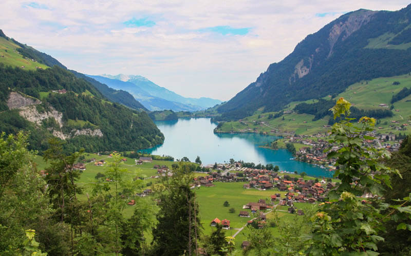
This beautiful lake in the Swiss mountains is a great choice for an easy stroll with mountain views. If the lake wasn’t enough, there is a even a short detour to two beautiful waterfall viewpoints.
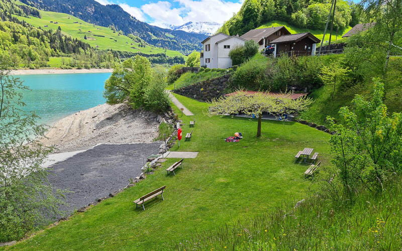
Along the lakeshore, you’ll find lots of picnic areas with fire pits plus restaurants on both ends of the lake. Since there is public transportation on both ends of the lake, you can easily just walk half the trail instead of the full loop.
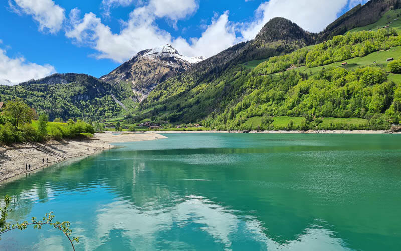
In summer, you can camp next to the lake and swim at the badi with a big waterslide. A great choice for May and early June when higher elevation trails are covered in snow.
| Location: | Obwalden, Lucerne Region |
| Address: | Lungern |
| By car: | Parking: Loppstrasse, 6078 Lungern 35 mins from Luzern, 1hr10 from Zürich |
| By public transport: | Lungern train station 48 mins from Luzern, 1hr40 from Zürich |
| Trail: | 9.5 km, about 2hr30 (shorter version below) |
| Elevation: | highest point 765m, 140m up, 140m down |
| Condition: | gravel |
| Skill: | easy |
| Open: | April to October |
| More info: | obwalden-tourismus.ch • webcam |
Location
Lake Lungern (aka Lungerersee) is located in central Switzerland, halfway between Luzern and Interlaken. It is easily accessible by car or public transportation.
Many will be familiar with this lake from a popular viewpoint from the road that leads to Interlaken.
Trail map
The trail loops around the lake, easy walking, mostly on a gravel path, sometimes paved. It is suitable for strollers with minor adjustments as detailed below.
See trail map on Komoot • SchweizMobil • AllTrails • OutdoorActive
There are restaurants and swimming areas on both ends of the lake and lots of picnic areas with fire pits and wood scattered along the trail. There is a public toilet near the swimming badi in Lungern and one at the Kaiserstuhl restaurant.
Tip: The west side of the lake gets really shady in the afternoon because of the angle of sun. So if you want lots of sun, do the west side in the morning when the sun is hitting that side. We were thankful for the shade because it was a hot day. But maybe you prefer it sunny.
This labeled maps shows all the important points along the way. I didn’t mark the picnic areas because there were so many!

Shorter version
There is a train station at either end of the lake, Lungern and Kaiserstuhl OW. You could walk just one side of the lake and catch the train back to your starting point.
For strollers
If you have a stroller, you can do the whole loop except the short section where the trail heads into the hills, which I show in the photo story below. Instead, stay on the sidewalk on the main road.
The paths will converge after about 1.5 km, about 20 mins. The path on the west side of the lake is wider, so a little easier with strollers than the east side.
Waterfall detour
Make sure to do the detour to the waterfall viewpoints as shown on the map below. The lower falls viewpoint takes about 2 mins and is very easy. The upper falls viewpoint is 430m, 99m elevation gain (about 10 mins) and is more difficult, climbing uphill on a narrow, slippery path. I would do both, but if you just do the lower falls, it’s still really good!

How to get there
By car: We drove to Lungern and parked in the free parking near the swimming area on Loppstrasse, 6078 Lungern. If that parking is full, there is a larger metered lot (CHF 5/day) next to the campground at Hinterseestrasse, 6078 Lungern. There is also limited parking on the Kaiserstuhl side of the lake near the restaurant and train station.
By train: Take a train to Lungern. It’s a short walk downhill from the trail station to the trail as shown here. Alternatively, you can take the train to Kaiserstuhl OW, a very short walk from the trail.
Photo story of trail
1. Starting in Lungern
Here’s the parking near the swimming area in Lungern. As far as I could tell, it was free to park here.

If that parking is full, you can park at the nearby campground parking. Some is public parking, some is reserved for the campground.

Here is the swimming area. In spring, the water level is very low. So the slides look crazy in my picture, apparently dropping you off a couple meters onto the ground. But in summer, they release more water from the reservoir into this lake bringing the water level up so you can swim here.

Starting our walk on the east side of the lake through the Lungern village.

The path narrows but still possible with a stroller.

There is a little “almost” island sticking out into the water. Great for a hot day with lots of grassy spots in the shade.

There is a firepit next to the island with wood.

Continuing our way around the lake. The water level was really low in late May.

So many great picnic areas with lots of wood.

View back down the lake, so pretty here!!!
2. Trail going uphill – strollers stay near the water
After about 1.5 km (20 mins) from the parking, you’ll see a trail sign and a faint trail going up the grass to the road. If you want to follow the “official” trail, take the fork to your right and follow yellow trail signs to Kaiserstuhl as we did. For strollers and those wanting to skip the climb, stay on the main path to your left following the white sign to Kaiserstuhl. You will join a sidewalk along the road. In about 1.5 km, the two trails meet each other again on a footpath along the lake.

The trail up starts on this road, up the hill.

You pass a dairy with a self-service cheese fridge. You can pay with Twint. It was delicious! Keep following yellow trail markers as shown here.

The path goes above the train tracks and is one of the prettiest parts of the walk.

So many wildflowers up here! Eventually the trail descends on a narrow footpath through the forest.

Then down and under the train tracks back to the lake shore.

Follow the road under the train tracks, then turn right and follow trail signs to Kaiserstuhl.

3. Trails merge, continue along water to Kaiserstuhl
All paths merge again near the road and follow a footpath near the water until you reach Kaiserstuhl on the north end of the lake.

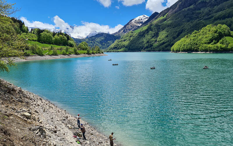
Lots of people fishing on this side of the lake.

I was slightly grumpy on this very short section next to the road. The path was actually very well made (thank you Obwalden Kanton!), but walking next to the road is not my first choice.

4. Take a break in Kaiserstuhl!
At the north end of the lake, it’s quite busy. Lots of people starting and finishing their day here, others taking a break. You’ll find this restaurant, which as a self-service cafe where we ate and also a sit-down restaurant with indoor/outdoor seating.

We had the fried fish, since this lake is so popular for fishing. The portion was very large, more than enough for two people in my opinion. They had a very nice house-made iced tea and some pretty cakes. The restaurant has a large menu with traditional Swiss dishes.

View of the lake from Kaiserstuhl.
5. Back on the trail
Keep following the path along the water to the west side of the lake. There is a water fountain here to refill your bottles.

On the path below the road for a bit.

There is a swimming area on this north end. It looks free but since we were there out of season, I’m not 100% sure of that. In summer the water comes up to meet the grass.
The “trail” continues on a paved road for about 10 mins. It was also extremely busy, which was odd because the rest of the trail was so quiet. The road and trail forks at the sign shown on the left below. For the lake trail, stay left. The trail to the right goes straight up the mountain.

Still a road for a few minutes, but quiet and pretty.

So many nice views of the lake on this side.

Then the paved road turns into gravel, nice wide path, easier for strollers than the east side. A few picnic areas with fire pits on this side too.

More pretty views.

We were just walking on that other side, remember?

6. Detour to waterfalls
Just before you reach the south end of lake, you’ll see some signs pointing to the waterfalls. You can’t see them directly from the main path you are on.
To reach the lower falls, it’s a very short and easy path directly up the river flowing from the falls. It takes not even 2 mins to get this beautiful view of the falls.

For the upper falls, backtrack a bit to this sign and follow signs to Dundelbachfälle on the narrow footpath. It’s about 430m and 99m of elevation gain. The sign said 20 mins but it only took us about 7 mins, not walking fast at all. I’d say maybe 20 mins round trip with a few minutes at the falls.

The path is steep and slippery, with some stairs.

Last bit in the sun that leads you to the upper falls shown here, totally awesome. You could hypothetically scramble down to the water but there are signs warning you that the “TRAIL ENDS HERE!”. I’m guessing some dum-dums got hurt so they put up that sign. Switzerland is not big on warning you about danger. So when they do, you know they are serious.

7. Ending the trail in Lungern
Retrace your steps back to the road and follow it all the way back to your car or Lungern train station.

Looking back at the falls, such a pretty spot.

Apparently there is a footpath that cuts through the campground so you can walk near the water instead of the road. But we missed the turn off. So we continued on the road to our car.

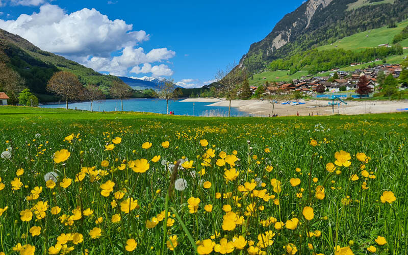
But it was a happy accident because I got this sweet picture with all the yellow flowers. Love this place!
Video of the trail
Here’s a video of our Lungern lake hike.
I hope you like this lake walk! Come back and leave a comment and let me know what you think of it.
See more alpine lake walks


10 Responses
Hi
Really nice home page you have here, so helpful!
I will visit my sun in Zurich in early oktober. Im coming with train from Sweden. Having a interrail pass. Want to take the PE-train from Luzern to Interlaken on a day excursion. But also want to hike a bit. is this path a good idea? and if I just go one way and continue with the train wich side should i choose? i want nice views, also on mountains around.
thanks in advance for helping!
Hi Marianne, If you are traveling from Lucerne to Interlaken, you could get off the train at the Kaiserstuhl stop, which is very close to the lakeshore. You could wander along that side of the lake and get back on at Kaiserstuhl. Or you could walk along the lake down to Lungern and get on the train station there. That might take about 90 mins. I like walking on the east side of the lake a little better. Have fun!
Hey, it’s a awesome blog with so much details, its very helpful!
We are planning to visit Lungern in the 3rd week of April. If we could do just a single side of the lake, do you suggest east or the west side ?
I prefer the east side. In that case, I would probably start at the north end of the lake and walk towards Lungern.
Hello! Does anyone know if dogs can enter? Thank you in advance!
I don’t of any restrictions for dogs entering the water here and I saw at least one dog swimming last time I went.
Hi Tanya and crew,
I’m new to your site and LOVE it!
We’re not that new to Switzerland, and have traveled about quite some, but your routes have re-invigorated our weekends. Thanks!
We did this hike yesterday, and FYI, there’s a huge white canvas tent over the car park you have pictured so others may find that helpful to locate. The parking schema on-site seems completely ignored, but it’s still free as far as we could ascertain.
Many cheery wishes and thanks for a super site!
Thanks for the information from your visit. I wonder if that white tent was temporary for an event or permanent for summer.
Thanks for the guide, this was a very nice hike. Quite a hidden gem too as I’d never been recommended it until now. Nice website btw 👍
Glad you enjoyed it! And thanks for this kind comment about my website.