This hike starts in Flims, with an easy walk through fields and forests to the dramatic Il Spir lookout over the Rhein Gorge. Then continue hiking down the gorge to the river below, where you can admire the interesting cliff formations from a different perspective. Then return by public transport to Flims or your home base elsewhere.
The view from below was just as beautiful and interesting as the one from above. We loved lounging at the river’s edge, throwing rocks and watching the kayaks go by.
It wasn’t as difficult as I expected. Our 4 year old hiked the whole thing pretty easily, with a couple lollipops for encouragement. This is a particularly nice option if you are staying in the Flims region and are looking for a little variety.
| Location: | Flims Laax region, Graubünden Switzerland |
| Start trail: | |
| End trail: | Versam-Safien train station |
| Car: | Park at Reichenau-Tamins train station (instructions below), then 20 bus to trail start from Chur 12 mins, Zurich 1hr15 |
| Train: | to from Chur 32 mins (Express bus), Zurich 1h51 |
| Trail: | 7.8 km one way, about 3 hours |
| Condition: | half dirt road, half narrow dirt alpine path, no strollers |
| Skill: | moderate |
| Open: | best late April to October |
| Prices: | tickets for train & bus for start and end of trail – about SBB Halbtax and Junior Card accepted |
| Services: | restaurant, fire pits, small playground |
| More info: | www.flims.com |
Trail Overview
This is a one way hike from Flims Waldhaus to the Rhein Gorge lookout, then down gorge to the river below. You could hike back up but we prefer to take the train back.
We hiked to Conn (about 1 hr), then down to the river (about 1hr15), then to the train station at Versam-Safien (about 30 mins), took the train back to Chur (about 20 mins), then another train to Zurich (about 1 hr).
Unlike the trail to Conn, this second section of the trail is not entirely stroller-friendly and the last section is a narrow footpath, with lots of bumps and switchbacks. So if you must use a stroller, just do the loop back to Flims Waldhaus as described in the other post.
How to get there
This is a one-way hike. So even if you arrive by car, you’ll need to take public transportation to access the trail.
By public transport:
Take Bus 81 or 411 to
The trail ends at Versam-Safien train station. If you are going to Chur or Zurich, catch the train headed to Chur, travel time 24 mins.
If you are going back to Flims, ride the train to Ilanz. Then bus to Flims.
By car:
We find it best to park at the Reichenau-Tamins train station.
Then walk about 12 mins to the Tamins, Underdorf bus stop. Ride Bus 81 to (21 mins) to start the hike.
The hike ends at the Versam-Safien train station. Ride the train to Reichenau-Tamins train station, where you left your car. This train departs once an hour, so check the schedule beforehand on SBB.ch so you can time your arrival.
Alternatively, you could park at the Chur station and do the round trip from there.
Photo story of trail
So assuming you made your way to the Flims Waldhaus bus stop, you follow signs to Conn. We started the trail in snow this time – I was worried but my husband was sure it would all work out.

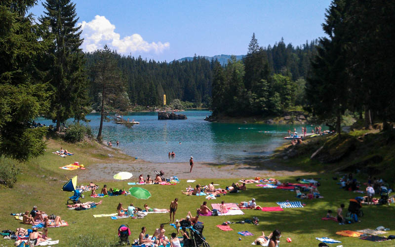
You will pass by the Caumasee lake. During summer (mid May to mid September), they charge a fee to get into the lake area. But off season, the gates are open and you can walk around freely.

When we did this hike in late April, we did a little detour down to the lake.

a little detour to Caumasee is nice
When you reach Conn, there is a good restaurant with indoor and outdoor seating. The service was timely and food delicious. We really liked the housemade raviolis. There’s a bit of play equipment behind the restaurant and some lounge chairs in the field.

restaurant is in this beautiful field … my super yummy lunch of fluffy polenta with mushrooms … gorgeous mountains in the background
Then follow signs to the lookout tower (Aussichtsplatform) and enjoy the view of the “swiss grand canyon” and surrounding mountains.

Aussichtsplatform and view of swiss grand canyon
Now you either retrace your steps and go back to Flims Waldhaus as I described in the first post. Or you can hike down to the river, as we did this time. Although the trail to Conn was very stroller friendly, your stroller will not make it all the way down to the river. It’s not particularly difficult but you will need to help small children on the last section. So just know what you are getting into. If you want to hike down to the river, leave the lookout tower and take the first marked trail to your right, away from Conn. After awhile, the trail signs will start listing “Versam Stn” as a destination. Follow that.

the train down to the river has wide and narrow sections … right before the really steep part, there is a nice Feuerstelle with firewood and tables, as shown above

strollers need not apply in the section of the trail … there were a few silly sculptures along the trail
After 10 minutes or so, the trail to Versam will head right off the main trail. It will descend rather quickly alternatively on dirt roads and narrow switchback paths until you reach the train tracks crossing the river. Go up the steps and cross the bridge next to the train tracks. On the other side, descend the steps and join the trail.

reaching the river, crossing the bridge and looking back up to the lookout tower at the top

After the bridge, the trail continues through a forest and passed another picnic area. The signs are good and have maps showing you exactly where you are on the map.
After a couple minutes, the trail spills into a picnic area where you can explore the river’s edge and get a good view back up to the lookout tower. The river is too dangerous for swimming, so watch small children carefully. There are lots of places to build a fire and plenty of wood. There’s sand to dig in and lots of rocks to throw.

We spent a couple hours here, made a fire and roasted marshmallows, watched kayaks, got sunburnt, etc.

we found some fun sparkly rocks that split apart when you knock them together
When you’re ready to go home, rejoin the trail and walk on the narrow path over a little hill and back down to the river, following signs to Versam Stn. It’s a very lovely walk right along the river, but keep small children close.

The train runs about once an hour. So check the schedule beforehand do you don’t have to wait too long. There is a cafe next to the train station, but services are very limited. The train ride back to Chur takes about 20 minutes. I recommend getting some Bundner Nusstorte at the Chur train station – so yummy!

Happy hiking!






10 responses
Hi! Thank you for this very informative post. Any idea why Google Maps does not show this path going down from Il Spir to Versam Station?
Do you have pictures of the very steep part?
I am planning to do this hike alone and I cannot find much information on this.
I don’t know why Google maps does what it does. I included pics of this trail in my post, probably the best you’re going to find. I’ll have to take more next time I do this trail.
Thank you so much for the very useful and detailed information! We have done this hike today with our 7 year old and have loved it! The downhill part has been a bit challenging but the view and the final hike by the river worth the effort.
I’m so glad you enjoyed this hike! thanks for taking the time to come back here and leave a comment. It’s always so nice to hear about people’s experiences.
Hello!
Thank you for the wonderful information and photos you provided! I am wondering if hiking here is a free activity? And you just have to pay for the train at the end of the hike? If it is not free to hike, where would I purchase tickets in advance?
Thank you!
Hi. There is no fee to hike in this area. You only need to pay for public transportation to access the trail. Have fun!
Dear Tanya, my name is Tanya too, from Brisbane Australia. My daughter and i are planing to travel around Swissland for 20 days by STP from 28 sep to 19 oct. We will arrive in milan from brisbane. Then travel from milan to tirano then st Moritz will visit Diavolezza and ospizio berninaand chur ( plan to visit Rhine gorge, albula tunnel landwasser viaduct.
Should we stay over night in st Moritz and Chu. Or somewhere near ?
I would like to have you advise. Thank you
Hi! I would probably stay in St Moritz for the activities you have in that region (we love Hotel Waldhaus on the lake). Pontresina would be a good second choice. For your activities near Chur, you are right that Chur is probably the most convenient to access those activities. Good luck!
great hike for the family. Thanks for the fantastic write-up, we really enjoyed it.
I did this hike backwards and it was pretty steep. The views and the food at the restaurant in Conn made it worthwhile. I love this area. Great pictures, Tanya!