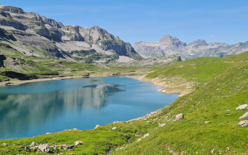
This hike loops around a beautiful alpine lake with views of the surrounding spiky peaks. It’s easy walking with minimal elevation gain, suitable for beginner hikers and families. One side of the lake is a wide gravel path, possible with all-terrain strollers.
There is a mountain restaurant before you reach the lake, but no other services. I’d suggest a bringing a picnic to enjoy lakeside, while the kids throw rocks and dip their toes in the chilly water.
Contents
| Location: | Muotathal, Lake Lucerne Region |
| Address: | Sahli-Glattalp cable car – Sahliboden, 6436 Muotathal |
| Car: | Parking next to cable car: 46°54’49.9″N 8°50’47.7″E 1hr10 from Zurich or Lucerne |
| Train: | Bus stop: Bisisthal, Sahli Seilbahnstat. (very infrequent) 2hr from Zürich |
| Trail: | 7 km loop, about 2 hr walking time |
| Condition: | partial dirt/gravel, partial rocky alpine trail option for all-terrain strollers as described below |
| Skill: | easy |
| Services: | restaurant near cable car |
| Cost 2025: | Cable car round trip: CHF 24 Adult, CHF 12 Child no discounts |
| Open: | June thru October |
| More info: | glattalp.ch • webcam • weather |
Gallery


Trail map
This trail starts at the top of the Glattalpsee cable car and loops around the lake. The full loop is 7 km but you don’t have to walk all the way around the lake.
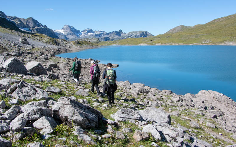
The trail is mostly a wide gravel path suitable for strollers. However, the trail on south side of the lake is a narrow, rocky path. So with strollers, stay on the north side.
There is a restaurant near the top of the cable car but besides that, no other services. You can build fires here, but there are no official fire pits and no wood. I don’t know if swimming is allowed in the lake, but the water is sure to be chilly, even in summer.
There is a trail from the valley if you prefer to skip the cable car in either direction.
Getting there
The Glattalpsee lake is located in the Muotathal valley near Lucerne (see on Google Maps). The hike is accessed by a small cable car, easily reached by car or bus.

By car:
Drive to Schwyz, then follow signs to Muotathal, driving all the way down this valley to the end (46°54’49.9″N 8°50’47.7″E).
Note: there are a couple speed cameras along this route, so monitor your speed. Near the end of the valley, the road narrows to one lane and you’ll need to drive carefully and watch for cows and tractors.
By public transport:
You would need to take a train to Schwyz, Bahnhof, then Bus 1 to Muotathal, Post, then Bus 506 to Bisisthal, Sahli Seilbahnstat. The bus runs infrequently, so check the schedule carefully.
Planning your day
Ticket prices
In 2025, a round trip ticket on the cable car costs CHF 24/adult and CHF 12/child aged 6-15.
No discounts for travel passes or cards. See current prices.
Opening hours
The gondola is typically open for summer season from June through October.
It runs every 30 mins from 8:02-17:02, until 18:02 on weekends, holidays and high summer. They take a break for lunch from 12:00-13:00. The gondola may run more frequently if there are at least 3 adults.
Photo story of trail
Here’s the cable car station. You buy your ticket at the window. They will give you a numbered token, which indicates which cable car you will be on (1 to 12).

With this system, you don’t have to wait in line to hold your spot. When they call the number, then get in line for the next arriving cable car.
The cable car is tiny, fitting only 8 people. On a busy day, you may have to wait awhile for your turn.

At the top, follow the signs to the “See,” aka lake, on the wide gravel path shown here.

The trail signs are ridiculously tall, presumably because they get a lot of snow in winter. They were so tall, we couldn’t read the text. But the trail is easy, you won’t get lost.

The restaurant is very close to the cable car station. It doesn’t have a view of the lake, so you might prefer to picnic when you get to the lake.

At about 1 km, the trail splits. If you have a stroller, take the left fork, which remains a wide gravel path all the way to the end of the lake.
If you take the right fork, it turns into a narrow, rocky footpath when you reach the lake. The trails connect at the far end of the lake.

It’s about 2 km before you reach the lake. Here’s our first look at the lake from the path on the left.

Showing how the path cuts across the hillside, very flat and easy walking.

Looking back from whence we came.

Reaching the far end of the lake, where the wide smooth path ends and the narrow footpath begins.

Looking down the water.

One time we hiked upstream for a few minutes towards the pass.

It’s a nice place to take overview pics of the lake.

At the far end of the lake, you have to cross the river to continue the loop. The first time we went on 15 Sept 2015, the bridge was gone so we had to walk over these steps.

The second time I went on 12 Sept 19, there was a bridge. So I suspect in summer season there is a bridge, then they remove it in fall.

Someone went a little cuckoo with painting the trail markers.


The path back along the south side of the lake is very rocky, but still quite easy.

Looking back at the far side of the lake.

Also fun in the fog.

We had our picnic in the rain, cuz we’re crazy like that. I’m sure you’ll have better weather.

My boys enjoyed climbing around on the boulders along the path.

Passing a smaller lake on the way back.

In fall, the water levels can be quite low.

Another little pond on the way back.

We wandered around the hills a bit, off script. From up there, we had this nice view down to the main trail.

Make your way back to the cable car and ride back down. If you want to keep walking, there is a trail down the mountain to the valley station, as shown in the picture below. We were almost tempted to hike down but we decided to save our knees.

I hope you like this one!


One Response
This summer this lake was overflowing everywhere and there was quite a lot of snow. We had a picnic there and passed it to go all the way and the end of the valley and passed it to spend the night with our tents in a great spot. Exhausting and a bit sketchy with the snow, but unforgetable! We went on in the Glaris for 2 more days but there were signs to go back down on the other side of the valley, in the Oberblegisee area I think. If interested in info or crazy photos some day, let me know!