Creux du Van is an impressive natural rock arena in northwestern Switzerland, with a long half circle of sheer cliffs 150m tall.
For an easy outing, you can drive and park just 300m from the cliffs. Then a short walk to the viewpoint and optionally stroll along the cliffs, either on the edge or behind a stone wall for safety.
For a longer adventure, you can hike up from the valley and earn your view. Details for both paths below.
Contents
| Location: | Western Switzerland |
| Address: | Val de Travers region |
| Car: | Parking near Restaurant Le Soliat (46°56’09.8″N 6°42’56.5″E) 1hr15 from Bern, 2hr15 from Zurich |
| Train: | Closest stop: Noiraigue train station, then 4km hike to cliffs. 1hr10 from Bern, 2hr from Zürich |
| Trail: | 300m to viewpoint, optional 2 km each way along cliffs |
| Condition: | dirt rocky trail, best without strollers |
| Skill: | easy |
| Open: | April through November, weather dependent |
| Cost: | free |
| Services: | restaurant with playground, no official picnic area |
| More info: | www.lesoliat.ch |
Hiking map
You can drive up a country road almost all the way to the cliffs, parking at the Le Soliat restaurant.
Then a 300 m walk to the viewpoint. You can optionally walk along the cliffs for about 2 km each way, either next to the edge or safely behind a rock wall.
Safety with children
As the cliff edge is not blocked fully by a safety fence, the cliffs can be very dangerous, especially with young children.
However, there is a stone wall setback from the edge, lining most of the cliffs allowing children and more timid adults to safely enjoy the view with some protection.
Behind the cliffs, there are meadows with plenty of room to safely run about and find a good picnic spot. Near the car park, there is a restaurant and playground.
Longer hike
If you want a longer hike or are coming by public transport, you can hike up from the Noiraigue train station in the valley on Route 286.

It’s a steep 4 km hike up to the cliffs, about 650m in elevation gain. We saw many people doing this hike and my 10 year old did it with his school class once on a class trip.
See trail map on Komoot
Getting There
The Creux-du-Van cliffs are in western Switzerland near Neuchatel.
By car:
You can drive almost all the way to the cliffs viewpoint and park next to Le Soliat Restaurant (GPS: 46°56’09.2″N 6°42’55.7″E).
Sometimes this parking is closed and you have to park about 2 km further back on the road here: 46°55’20.9″N 6°41’56.6″E
There are multiple ways to drive there. A local recommended following the main road along the lake to Saint Aubin, then taking the country road north up the mountain, passing through Montalchez and Rougemonne before arriving at the parking.
The first time we visited, we left the main road at Neuchatel, drove to Travers, then south on the country road to the Le Soliat parking. Either way will get you there.
By public transport:
There isn’t a bus stop near the cliffs. The closest stop is the Noiraigue train station in the valley. Then a 1hr20 hike up to the closest cliffs viewpoint as described above.
Photo story
Arriving at Le Soliat parking
After leaving the main road, the country road leading to Le Soliat is a wide curvy single lane road, but it’s well maintained and has lots of areas to pass other vehicles. The road ends at Le Soliat, where there is a big car park next to the farm/restaurant with a car park. This is where you start walking.

There is a small play area at the restaurant, but I recommend hurrying along and using this as a reward for good hikers. To start the hike, simply walk straight out into this field and in a couple minutes, you’ll hit a stone wall. You can’t miss it.

Walking to cliffs viewpoint
The path out to the cliffs it not well-defined but it’s hard to get lost.

This stone wall surrounds the entire cliff area, good for keeping out cows and children.

Ta-da! You see this amazing view as soon as you hop over the wall. The photo is nice, but it doesn’t capture how impressive this really is.

View the other direction.

Walking along the cliffs
Obviously the cliffs made me very nervous with kids. I made them hold my hands most of the time. We started walking on the trail that goes along the cliff edge.

The path is quite wide with room to steer clear of the edge, so hypothetically dangerous if you stay away from the edge. But all the same, with children, I was uncomfortable.

Needless to say, this trail was not stroller friendly, quite lumpy with rocks.

However, since the stone wall surrounds the entire area, you can have children walk on one side of the wall and adults on the other and still practically walk together. The trail on the meadow side is possible with a stroller. There are openings in the wall every few minutes in case you need to cross over. My husband and I took turns, trading off who walked with the kids and who walked near the cliff.

The cliffs are super steep and people love to stand right on the edge, taking pics.

Hey, I’m on this hike too!


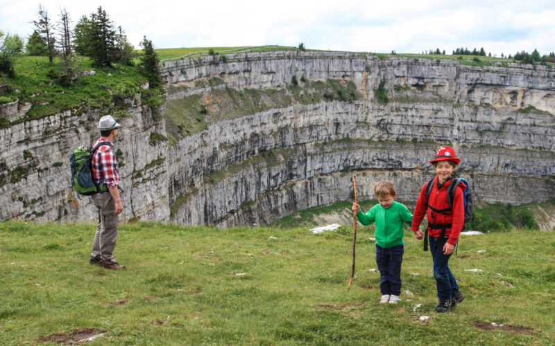
There are plenty of photo ops that don’t require getting super close to the edge. In this photo, our kids were at least 20 or so meters from the edge.
Exploring away from the cliffs
On the non-cliff side, there are also interesting rock formations on which our kids loved to climb.

After leaving the cliffs, the trail continues into the forest. Although there were no official “Feuerstelle” there were lots of make-shift grill pits along the trail. We found it a little difficult to find dry wood, but we managed a big enough fire for a few cervelat and marshmallows.

When you’ve had your fill, retrace your steps back to the restaurant. We didn’t eat there but the place was hopping, most people with just drinks, not food. The menu was limited with mostly fondue and cold plates.

Nearby: Areuse Gorge, a long but easy hike through a beautiful river gorge.


2 responses
Thanks for the write up! Which date did you do this hike? It looks very flowery and green 🙂
I think the pic with the flowers was in late July. But I’ve been there in early June and it was also very nice.