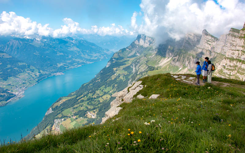
I’ve always wanted to stand at the top of those spiky Churfirsten peaks that loom over the Walensee and it was even better than I had hoped. A funicular and cable car whisk you to the top at 2262m, where you get amazing views in every direction. From here, you can wander on the short and easy panorama loop around the high, wide plateau at the top.
The trail is not difficult, but there are cliffs on all sides and no barriers so you need to keep a close eye on children. There are tons of wildflowers on the path and signboards describing them, with interesting facts. It’s an impressive outing, a good choice for visitors.
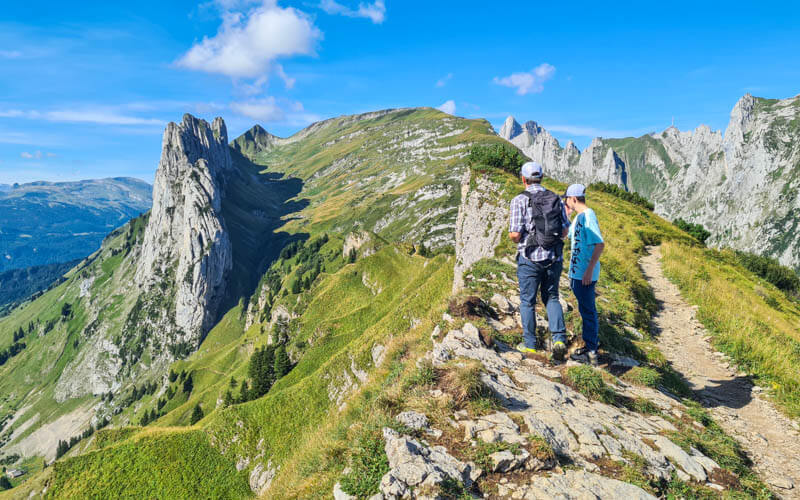
If you want a longer hike, we recommend adding on the hike down from Chäserrugg to Gämseralp, a really beautiful hike and not very difficult. Or ride back down to the middle station in Iltios and join the Toggenburg Tone Trail, with 20+ interactive musical stations along the trail.
Contents
| Location: | Eastern Switzerland, Toggenburg |
| Address: | Unterwasser-Iltios funicular: Früeweidstrasse 1950, 9657 Alt St. Johann |
| Car: | Parking at Unterwasser: Früeweidstrasse 1950, 9657 Alt St. Johann (47°11’42.1″N 9°18’33.1″E) 1hr20 from Zürich |
| Train: | Bus stop: Unterwasser, Post 2hr from Zürich |
| Trail: | 3 km loop, about 1 hr |
| Elevation: | highest point 2262m, total climb 80m, total descent 80m |
| Condition: | lumpy dirt path, not suitable for strollers |
| Skill: | easy |
| Open: | mid June to October |
| Cost 2023: | Funicular + Cable car return: Adult CHF 62, Child CHF 29 SBB GA, Half-fare and Junior cards accepted |
| More info: | www.chaeserrugg.ch • webcam • forecast |
Gallery


Location
This trail is located in eastern Switzerland in the Toggenburg area (see on Google Maps). The trail is reached by funicular and cable car.

Here is the summer hiking map for the Chäserrugg area. To reach this panorama trail, you catch the funicular train in Unterwasser/Alt St Johann. At the middle station Iltios, you switch to a cable car that takes you to the top at Chäserrugg. The trail starts and ends here.

The satellite map gives a little more perspective of where you are in relation to the cliffs.

Hiking map
The trail is a 3 km loop on a wide, high plateau with cliffs on either side. The path is set back from the cliff edge but there are no barriers. The path itself is a narrow dirt path, with rocks and lumps to navigate, but not particularly difficult. It’s not suitable for strollers. You don’t need hiking sticks.

See this trail on Komoot • SchweizMobil • OutdoorActive
Longer option: Instead of riding down the cable car, hike down and across to Gämseralp, the mountain next door. At the end of the hike, you ride down a chair lift, then a bus back to your car at Unterwasser. See trail info.
With kids: You can ride back down to the middle station in Iltios and join the Toggenburg Tone Trail, with interactive musical stations along the trail.
How to get there
By car: Drive to Alt St. Johann and follow signs to the Iltios funicular (Früeweidstrasse 1950, 9657 Alt St. Johann). There is free parking next to the base station. The road to Alt St Johann is a regular two lane country road, easy to access.
By public transport: Take a train to Wattwil, then bus 770 to Nesslau, then bus 790 to Unterwasser, Post. Alternatively, take a train to Buchs, then bus 790 to Unterwasser, Post. The funicular station is a short walk from the bus station, as shown below.

Planning your day
Ticket prices
You need a return ticket from Unterwasser to Chäserrugg, which includes the funicular train from Unterwasser to Iltios and the cable car from Iltios to Chäserrugg.
In 2023, this ticket costs CHF 62/adult and CHF 31/child 6-15, under 6 free. Discount of 50% for Swiss Travel Pass, SBB Half-fare, GA, SBB Day Pass. SBB Junior card rides free. Check website for current prices.
Opening times
The mountain transport is open from the end of May through mid-October, daily 8:30 to 17:00 running every 30 mins. Check the website for current timetable and schedule (click the “Opening Hours” link on the pink bar at the bottom of the page).
Photo story of the trail
1. Riding up to Chäserrugg
Getting on the funicular train at Unterwasser.

Going up the cable car from Iltios

The cable car station at the top.
View from the top of Chäserrugg down to Walenstadt.

2. Starting with the flower garden
Starting the path down from the Chäserrugg cable car station and restaurant complex at the top.

On the the panorama path looping around the plateau below.
So many flowers on the path.

One of the many flower signsboards.

A beautifully rocky landscape.


There are several benches along the path. Nice place for a picnic.

Looping around the plateau
We usually hike clockwise, but it doesn’t really matter.
Pretty easy walking on this footpath.
Views east from the panorama path.

Views toward Liechtenstein.
View at the end of the loop. You can walk farther down to that pillar rock, but we just continued the loop back.

Finishing up the loop, heading back to the cable car station.

This is our favorite place for pics, with both the lake and cliffs in view.
Walking back up to the cable car station.
3. Add-on trails
If you want to keep walking, you can hike down from Chäserrugg to the middle station at Iltios or to the Gämseralp lift to the east, which is what we did. Details here.

You could also ride down to the middle station at Iltios and join up with the Toggenburg Tone Trail, with 20+ interactive musical stations along the way.


2 responses
Hello, thank you so much for providing all the trails information. We used your website extensively for our family hiking trips, and found it really helpful, really appreciate your efforts.
BTW, I found an error in this page, the parking location (GPS coordinates) is incorrect, it points to Stoosbahn.
Best Regards
Lin
Thanks so much for pointing out this error! I’ve fixed it now. Glad you have found the blog useful. Wishing you many more fun hiking adventures.