During our weekend in Bellinzona, we hiked in the hills above the castles, which made for a more dramatic arrival. This hike starts in the old town and does a loop through the vineyards and forests above Bellinzona before eventually reaching Sasso Corboro, the castle highest up on the hills. After touring this castle, you can continue the hike back down the village, stopping at the Montebello castle on your way and finish the day at the third castle in right in Bellizona.
Contents
If you want to skip the hike and just visit the castles, you can take a shuttle. See my post: How to visit the Bellinzona Castles.
Note: We visited the Bellinzona as part of a press trip sponsored by Ticino Tourism, with partner Rapelli. All opinions stated here are our own.
| Location: | Ticino, southern Switzerland |
| Trail head: | Bellinzona old town or train station |
| Car: | Parking: Piazza del Sole 7, 6500 Bellinzona From Locarno or Lugano 28 mins, from Zürich 2hrs |
| Train: | Train station: Bellinzona, Stazione From Lugano 21 mins, from Locarno 28 mins, from Zürich 1hr41 |
| Trail: | 8.5 km loop, about 2.5 hrs with kids |
| Elevation: | highest point 622m, total climb/descent 420m |
| Condition: | regular hiking trail, mostly dirt path with some stairs, no strollers |
| Skill: | moderate |
| Open: | April through early November |
| Cost 2022: | hike free, optional entrance fee to castles get Ticino Ticket from your hotel for free for discounts |
| More info: | www.ticino.ch – webcam |
Overview of Bellinzona Castle Trail
This trail starts in the center Bellinzona (you could start the train station), wanders through quiet neighborhoods to the forest, climbs up the hill, loops around through a forest, then descends back toward Bellinzona, passing Sasso Corbaro and Montebello castles on the way. You finish the hike in the old town of Bellinzona, where you can get gelato and optionally visit the third castle, Castelgrande.
If you want a shorter hike, you can skip the hills behind the castles and do a 5.5 km loop to the three castles as shown below, about 1hr30 walking time. For details, see this loop trail between the castles.

Visiting the castles
If you want to enter each castle, consider getting the Bellinzona pass, which covers entrance fees for all three castles and their museums: CHF 30 for a family. You get a discount with the Ticino ticket, which is available for free from your hotel, hostel or campsite and covers public transportation through the Ticino region during your stay.
If you want to skip the hike and just visit the castles, you can take a shuttle. See my post: How to visit the Bellinzona Castles.
Trail Conditions
This is a mountain trail, mostly with a narrow dirt path, lots of stairs. So no strollers. I found the downhill parts a bit slippery, so best to bring your hiking sticks. There are no cliffs or drop-offs. It is small for small children.
The path was well maintained and clearly marked, but make sure you are following the correct signs, first to Prada (the half-way point), then towards Artore but heading off to Sasso Corbaro (the highest castle), then following signs down to Montebello and finally to Bellinzona.
The trail is official rated easy, but I would rate it moderate with kids. The full loop is about 8.5 km. The difficult part is the elevation gain, which is about 420m up over the first half, then back down on the second half.
Photo story of the trail
We started the hike at the Bellinzona train station. We walked through the old town, visiting the Saturday market and picking up supplies for lunch. Here we are leaving town, on the trail.

The trail begins by walking through some quiet neighborhoods.

You also pass some really old buildings.

Then you see a trail sign pointing up the hill. Follow signs to Prada, which is the halfway point.

The forest section starts with lots of stairs.

And views of the valley.

We passed lots of vineyards.

Follow the path across the road.

Follow trail signs along the next road for a bit.

There were a couple fountains with drinking water on the path. The trail was mostly well marked with the red/white striped markers.

We passed one picnic area about an hour into the hike. There were fire pits but also signs saying fires are prohibited because it’s too dry.

The forest gets a little denser and you cross a couple streams.

More stairs up and down.

Arriving at Prada, the half-way point, where you’ll find a little church and some ruins.

From Prada, follow signs to Artore. Before you get to Atore, turn left following signs to Sasso Corbaro castle. We took a wrong turn following signs to Ravecchia Ospedale. We eventually made it to the castle but had to walk back up the castle hill on a street, not recommended.

Arriving at Sasso Corbaro castle
The trail joins a road leading to Sasso Corbaro, the highest castle on the hill. You pay an entrance fee to visit the small museum and walk on the ramparts. If you plan to enter all three castles, make sure to get the Bellinzona pass, which covers entrance fees for all three castles and their museums: CHF 30 for a family. You get a discount with the Ticino ticket.

We spent about 20 mins walking around the castle walls, admiring the view.

Then we settled in for a picnic outside the castle walls. We had a yummy spread of Rapelli salami (a popular Ticino salami maker), local cheese from the market, fruit and bread, a classic Ticino meal. I loved using this cool hiking cutting board from Rappeli that has a little slot to hold the knife. We’ll be using that all hiking season for sure.

Hiking down to Montebello
The path continues through the forest below the Sasso Corbaro castle toward the Artore village. Then you connect to the road and follow the white castle signs shown below.

The trail leaves the road, following this green arrow painted on the ground. We missed it the first time and had to back track a bit.

Then a small footpath between some houses.

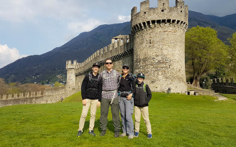
Arriving by trail means you get this beautiful view of the Montebello from above, the prettiest of them all, we think.

Great place for a family pic. We spent another 30 mins or so exploring this castle and museum.

They have some nice picnic tables in front of the castle with a great view.

Finishing the hike in Bellinzona
From Montebello, walk down along the castle wall into Bellinzona. There are lots of stairs.

The trail leads you to the old town center. We got gelato at Gelateria Veneta (everyone says this is the best!) and hung out on the plaza.

Continue to Castelgrande
If you want to visit castle 3: Castelgrande, continue walking through town until you reach this plaza. Piazza del Sole. Follow signs to the lift, which is through the tunnel shown below.

The lift takes you up to the castle grounds, some of which you can explore for free. You can pay a small fee to visit the castle museum and more of the castle.

Getting to Bellinzona
You can start this trail from anywhere in the old town of Bellinzona or train station.
By train: It’s best to take the train to Bellinzona because a) it’s an easy fast connection from Zürich or Luzern and b) you don’t risk getting stuck in Gotthard tunnel traffic, which is notoriously bad on weekends and holidays. The old town and main castle are an easy 600m walk from the train station.
From Zürich, a direct train runs twice an hour, taking only about 1hr45 mins. A round trip ticket with a SBB Half-fare card costs CHF 59.90. They regularly offer Sparbillet discounts on this route if you book early.
By car: Drive to Bellinzona, taking the exit 45 off the A2 freeway and following signs to town.

There are several parking areas in town and street parking in the neighborhood surrounding the old town center. The closest parking to the castle is Autosilo Piazza del Sole (Piazza del Sole 7, 6500 Bellinzona). One website says it charges about CHF 12 for 5 hours. This parking is accessible by lift and so is the castle. Another option is P+Rail Bellinzona at the train station (currently 80 places, open 24/7, CHF 12/day).

See also other hikes in the Ticino region and our other Bellinzona posts.
Pin this for later


2 responses
Was this hike 2.5 hours to the castles or roundtrip?
The full loop hike we did took about 2.5 hrs. If you want to just hike up to the castles, that would be shorter. I show that shorter variation on the website, about 5.44 km and 1hr30 walking time. You can visit the castle in Bellizona old town without any hike at all. And you can take a shuttle to the other two castles. Hope that helps.