This trail loops around the alps above the Näfels Obersee lake, passing through pretty meadows and shady forests, surrounded by tall mountains.
It was so much nicer than I expected! I worried that too much of the trail would be in the forest. But the trail dips and in out of the trees frequently, so you can enjoy both the views and cool shade from the hot sun.
We love that this trail is totally free – no cable car and so far the parking is free too. But unfortunately, no bus service to this lake. So if you are coming by public transport, you would have hike up from the valley or invite a friend with a car.
Have fun out there!
Contents
| Region: | Glarnerland, southeast of Zurich |
| By car: | parking at Näfels Obersee lake From Lucerne 35 mins, Zürich 1h10 |
| By public transport: | No bus service |
| Trail: | 11 km loop • see trail map |
| Time: | 3h30 walking time |
| Difficulty: | moderate • 560m up & down |
| Condition: | dirt footpath |
| Elevation: | highest point 1440m |
| Open: | late May thru October |
| Cost: | free |
| Extras: | restaurants at start and middle of trail |
| More info: | trail 823 info • webcam • weather |
Gallery


Trail map
The map below shows the loop trail, starting at the Näfels Obersee lake. We prefer hiking clockwise, but it would be nice in either direction.
See trail map on Komoot • SchweizMobil • OutdoorActive
The trail is well-built and not dangerous. It has lots of uneven terrain, so best with sturdy hiking shoes and sticks if possible.
For a shorter hike, just walk around the Näfels Obersee lake, about 35 mins.
How to get there
This trail starts at the parking next to the Näfels Obersee lake – see on map.

To reach this lake, you must drive about 15 mins on a one-lane winding mountain road with turnouts. Unfortunately, no bus service here.
Planning your day
Opening Times
This trail is relatively low elevation and usually free of snow from late May to late October.
Where to eat
The Berghotel Obersee restaurant is next to the parking. The restaurant is open Wed – Sun. It has a playground.
Otherwise, no services along the trail.
Photo story of trail
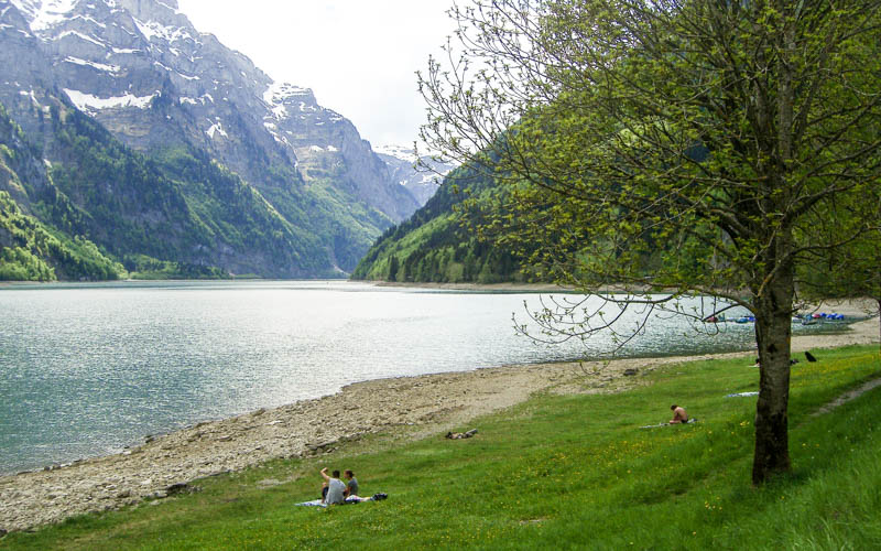
1. Starting at the lake
The parking area is near the Obersee lake and the Berghotel Obersee. Near the parking, there is a water fountain and portable toilets.

Hopefully you’ll get this pretty reflection when you start your hike.
The official 823 trail goes along the east side of the lake in the forest. But it’s much prettier to walk around the west side of the lake.

You’ll wrap around the far side of the lake, enjoying this meadow.

Looking back on the lake.

2. Walking along river
The path around the lake leads to a river. Turn left at this sign and follow the river. You will follow the green 823 Ahornenweg signs for the rest of the hike.


Walking parallel to the river through this meadow.
Then past this cute dairy hut.


You’ll pass this second smaller lake.
Just after the lake, turn left into the forest, following the trail signs.

3. Up through the forest
Now a short bit in the forest with lots of flowers. Make sure to follow the 823 trail signs if the trail forks.


Now the uphill climb for about an hour.

As you climb, you’ll get a bird’s eye view of the Obersee lake below.
Gets a little steep in the forest with some switchbacks.

Also some sections through meadows, passing some dairy huts and holiday chalets.

This water fountain is drinkable and for public use (see location on map). You can turn the tap to have a stronger water flow for your water bottle. The sign says to conserve water and don’t let it free-flow. Also dogs are allowed to drink, but not bathe in the fountain.

At Allenboden 1221m, you fork right and continue up through the forest.

The trail alternates in and out of the forest, giving you some breaks from the sun.

This sign is warning you that for the next 800m there is danger of rockfall. I’ve included a pic showing the peaks above the trail that may crumble on you.


Looking back on the trail through this rock fall section.

4. Back valley
Now entering the little cluster of chalets at the end of the valley – Vorderahornen 1323m.


Some tall mountains back here and cute chalets. No restaurants, water, toilets or other services. Just keep walking.
At this sign, fork right, following the 823 sign, direction Obersee.


Leaving this beautiful, peaceful valley behind.
5. Across and back down
Now a traverse through alpine meadows and shady forests.

Very happy to have more shade in the forest.


Looking back on the trail.
Passing by a few chalets.
Now some steep switchbacks in the forest for few minutes. Glad to have my hiking sticks for this part.

More grassy meadows.

Back to semi-civilization. At this sign, you join a private paved road that services this alp. Walk on the road for a bit, then back into the meadows.


Looking back on the trail.

Now last descent through the forest, back to the lake.


Hope you enjoy this one!